Refine your search
Sale Section
Estimate
Category
- Books & Periodicals (868)
- Prints (89)
- Maps (82)
- Collectables (81)
- Sporting Memorabilia & Equipment (40)
- Stamps (34)
- Models, Toys, Dolls & Games (26)
- Arms, Armour & Militaria (21)
- Photographs (17)
- Ceramics (5)
- Classic Cars, Motorcycles & Automobilia (5)
- Musical Instruments & Memorabilia (5)
- Drawings & Pastels (4)
- Entertainment Memorabilia (4)
- Jewellery (4)
- Sculpture (4)
- Fine Art & Antiques (3)
- Scientific Instruments (3)
- Taxidermy & Natural History (3)
- Watercolours (2)
- Cameras & Camera Equipment (1)
- Carpets & Rugs (1)
- Chinese Works of Art (1)
- Ethnographica & Tribal Art (1)
- Kitchenalia (1)
- Russian Works of Art (1)
- Silver & Silver-plated items (1)
- Textiles (1)
Filtered by:
- Item Type
- List
- Grid
This auctioneer has chosen to not publish their results. Please contact them directly for any enquiries.

One box: assorted postcards and cigarette cards
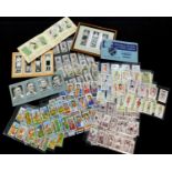
Box: assorted soccer cigarette and trade cards including WILLS: ASSOCIATION FOOTBALLERS, 1939,
Box: assorted soccer cigarette and trade cards including WILLS: ASSOCIATION FOOTBALLERS, 1939, complete set; JOHN PLAYER: FOOTBALLERS 1928-9 2ND S...

Old cigarette card album, and one smaller album, mainly part sets including Carreras 1924: HIGHWAYMEN, 20/25; 1924; FIGURES OF FICTION, 16/25 etc
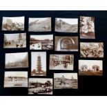
Packet containing 15 circa late 19th century real photographic postcards of China, of which 8
Packet containing 15 circa late 19th century real photographic postcards of China, of which 8 first Sino-Japanese War interest of Port Arthur (now...
Packet: large quantity GB QVId lilacs mainly on paper
Hoard of mainly GB G6th off paper stamps housed in box file
Box large quantity stamps in albums, on leaves etc
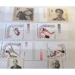
Album containing good quantity commemorative football stamps including World Cup 1966 first day
Album containing good quantity commemorative football stamps including World Cup 1966 first day covers, various worldwide stamps commemorating Wor...
Album GB collection from full set of Edward VII, QV overprints etc
Album cricket tour match first day covers from 1989 Ashes to 2001 (46)
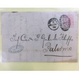
GB 1875 2pence halfpenny rosy mauve plates 1-16, all on covers to Italy including 3 entire letters (16)
Packet Liverpool & District postcards Edward VII-George V includes postmark and cachet interest (22)
Packet Liverpool & District postcards Edward VII-George V includes postmark and cachet interest (22)
Postal history including 1800 Scottish Bishop mark, a paid "tombstone" 1842 to Kings Lynn and 4 free
Postal history including 1800 Scottish Bishop mark, a paid "tombstone" 1842 to Kings Lynn and 4 free fronts with Sunday marks including 3 "scallop...
Stock card GB Mint controls George V-George VI (29)
Collection WWI and WWII Forces mail including several POW items and French patriotic
1838 entire letter from Dedham to Norwich and bearing a fine Colchester/penny post in red
Collection of early Cuba, Greece and Yugoslavia on stock cards
QVId red imperforates all with Maltese Cross cancellations and 3 with numbers in mix (21)
Australia, huge quantity of George V heads
Hungarian/German entire letter, 1862
Hungarian/German entire letter, 1862
Box: collection World stamps + GB first day covers
Four framed "Gold" 1981 fishing set first days covers (4)
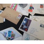
Collection mainly mid-20th century and later stamps in 2 albums, (World) + a few presentation packs,
Collection mainly mid-20th century and later stamps in 2 albums, (World) + a few presentation packs, first day covers etc
World collection mint and used stamps in 8 stock books + quantity loose
Box: containing large quantity stamp collections, museum cards, PHQs
World Mint and used collection in 4 albums and a cover album, GB with QEII 1952-90 + a few presentation packs
Two boxes World stamps, mainly GB, QEII, including unmounted mint commemoratives and presentation
Two boxes World stamps, mainly GB, QEII, including unmounted mint commemoratives and presentation packs etc, + some Jersey presentation packs
Extensive World stamp mounted mint and used collection in 13 Worldex albums, mainly post-war issues,
Extensive World stamp mounted mint and used collection in 13 Worldex albums, mainly post-war issues, + a box of assorted loose stamps in packets, ...
Four boxes: accumulation modern GB mint commemoratives etc + various mint and used World stamps in
Four boxes: accumulation modern GB mint commemoratives etc + various mint and used World stamps in various albums together with good quantity GB f...
World mint and used collection in albums, loose, sorted into packets + some covers etc, + a few
World mint and used collection in albums, loose, sorted into packets + some covers etc, + a few better stamps noted including West Germany 1956 He...
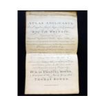
EMANUEL AND THOMAS BOWEN: ATLAS ANGLICANUS OR A COMPLETE SETT OF MAPS OF THE COUNTIES OF SOUTH
EMANUEL AND THOMAS BOWEN: ATLAS ANGLICANUS OR A COMPLETE SETT OF MAPS OF THE COUNTIES OF SOUTH BRITAIN DIVIDED INTO THEIR RESPECTIVE HUNDREDS, WAP...
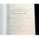
JOHN CARY: CARY'S NEW AND CORRECT ENGLISH ATLAS, BEING A NEW SET OF COUNTY MAPS FROM ACTUAL
JOHN CARY: CARY'S NEW AND CORRECT ENGLISH ATLAS, BEING A NEW SET OF COUNTY MAPS FROM ACTUAL SURVEYS..., London for John Cary, 1793, engraved title...
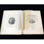
ROBERT LAURIE & JAMES WHITTLE: LAURIE AND WHITTLE'S NEW AND ELEGANT GENERAL ATLAS..., London,
ROBERT LAURIE & JAMES WHITTLE: LAURIE AND WHITTLE'S NEW AND ELEGANT GENERAL ATLAS..., London, 1808, 5th edition, added engraved vignette title dat...
GEORGE INGNAZ VON METZBURG: POSTE CHARTE DER KAISERL KONIGL ERLABANDEN... GESTOCHEN VON MANSFELD, [
GEORGE INGNAZ VON METZBURG: POSTE CHARTE DER KAISERL KONIGL ERLABANDEN... GESTOCHEN VON MANSFELD, [Vienna?], 1782, engraved folding outline colour...
L'ABBE DE GOURNE: ATLAS ABREGE ET PORTATIF..., Paris, 1763,engraved double page title, 5 double page
L'ABBE DE GOURNE: ATLAS ABREGE ET PORTATIF..., Paris, 1763,engraved double page title, 5 double page engraved hand coloured maps as called for, 4t...
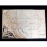
JOHN CARY: CARY'S NEW MAP OF ENGLAND AND WALES WITH PART OF SCOTLAND, London, 1794, engraved title
JOHN CARY: CARY'S NEW MAP OF ENGLAND AND WALES WITH PART OF SCOTLAND, London, 1794, engraved title page end dedication leaf, engraved hand coloure...
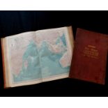
THE TIMES SURVEY ATLAS OF THE WORLD, 1920, folio, original cloth very worn and soiled, lower board
THE TIMES SURVEY ATLAS OF THE WORLD, 1920, folio, original cloth very worn and soiled, lower board detached, together with accompanying gazetteer ...

G W BACON (EDITED): COMMERCIAL AND LIBRARY ATLAS OF THE BRITISH ISLES FROM THE ORDNANCE SURVEY
G W BACON (EDITED): COMMERCIAL AND LIBRARY ATLAS OF THE BRITISH ISLES FROM THE ORDNANCE SURVEY WITH INDEX GAZETTEER, PLANS OF TOWNS..., London, G ...
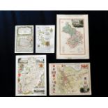
FOLDER OF ASSORTED MAPS including JOHN SPEED PLAN OF LEICESTER circa 1610, approx 145 x 145mm +
FOLDER OF ASSORTED MAPS including JOHN SPEED PLAN OF LEICESTER circa 1610, approx 145 x 145mm + OWEN/BOWEN: THE ROAD FROM KINGS LYN TO NORWICH...,...
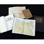
THE TIMES ATLAS, 1896, folio, original half calf worn + THE TIMES COMPREHENSIVE ATLAS OF THE
THE TIMES ATLAS, 1896, folio, original half calf worn + THE TIMES COMPREHENSIVE ATLAS OF THE WORLD, 2003, 11th edition, folio, original half leath...
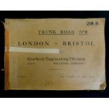
TRUNK ROAD NO 9 LONDON-BRISTOL SOUTHERN ENGINEERING DIVISION PART II WILTSHIRE, SOMERSET, circa
TRUNK ROAD NO 9 LONDON-BRISTOL SOUTHERN ENGINEERING DIVISION PART II WILTSHIRE, SOMERSET, circa 1933, 38 part coloured maps, oblong, folio, origin...
EMANUEL BOWEN: AN ACCURATE MAP OF THE COUNTY OF ESSEX..., engraved hand coloured map circa 1760,
EMANUEL BOWEN: AN ACCURATE MAP OF THE COUNTY OF ESSEX..., engraved hand coloured map circa 1760, approx 520 x 710mm, framed and glazed
![JOHN SPEED: NORFOLKE..., engraved hand coloured map [1676], approx 350 x 490mm, framed and glazed](https://portal-images.azureedge.net/auctions-2018/srkey10211/images/a89230c8-76af-4d99-c4d9-9a5a5496bb8a.jpg?w=155&h=155)
JOHN SPEED: NORFOLKE..., engraved hand coloured map [1676], approx 350 x 490mm, framed and glazed
JOHN SPEED: NORFOLKE..., engraved hand coloured map [1676], approx 350 x 490mm, framed and glazed
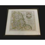
EMANUEL BOWEN: AN ACCURATE MAP OF NOTTINGHAMSHIRE DESCRIBING WAPONTAKES AND DIVISIONS..., engraved
EMANUEL BOWEN: AN ACCURATE MAP OF NOTTINGHAMSHIRE DESCRIBING WAPONTAKES AND DIVISIONS..., engraved hand coloured map circa 1780, approx 695 x 535m...
JOHN CARY?: AN ACCURATE MAP OF ENGLAND, SCOTLAND, AND WALES, DRAWN FROM THE LATEST AND BEST SURVEYS,
JOHN CARY?: AN ACCURATE MAP OF ENGLAND, SCOTLAND, AND WALES, DRAWN FROM THE LATEST AND BEST SURVEYS, engraved hand coloured map circa 1810, approx...
JOANNES BLAEU: NORTFOLCIA, NORFOLKE, engraved hand coloured map circa 1646, approx 375 x 495mm,
JOANNES BLAEU: NORTFOLCIA, NORFOLKE, engraved hand coloured map circa 1646, approx 375 x 495mm, framed and glazed
EMANUEL BOWEN: AN ACCURATE MAP OF THE COUNTIES OF LEICESTER AND RUTLAND, DIVIDED INTO THEIR
EMANUEL BOWEN: AN ACCURATE MAP OF THE COUNTIES OF LEICESTER AND RUTLAND, DIVIDED INTO THEIR RESPECTIVE HUNDREDS..., engraved hand coloured map cir...
STANFORD'S GEOGRAPHICAL ESTABLISHMENT (PUBLISHED): MAP OF THE PYTCHLEY HUNT SHEWING FOX COVERS AND
STANFORD'S GEOGRAPHICAL ESTABLISHMENT (PUBLISHED): MAP OF THE PYTCHLEY HUNT SHEWING FOX COVERS AND SPINNEYS, litho map, 1911, approx 595 x 650mm, ...
JOHN CARY: A MAP OF NORTHAMPTONSHIRE FROM THE BEST AUTHORITIES, engraved hand coloured map 1805,
JOHN CARY: A MAP OF NORTHAMPTONSHIRE FROM THE BEST AUTHORITIES, engraved hand coloured map 1805, approx 425 x 475mm, framed and glazed
![CHRISTOPHER SAXTON/WILLIAM KIP: NORTHAMPTONIAE, engraved hand coloured map [1607], approx 280 x](https://portal-images.azureedge.net/auctions-2018/srkey10211/images/65b4a4f7-033a-4c29-9860-6d4b7894455c.jpg?w=155&h=155)
CHRISTOPHER SAXTON/WILLIAM KIP: NORTHAMPTONIAE, engraved hand coloured map [1607], approx 280 x
CHRISTOPHER SAXTON/WILLIAM KIP: NORTHAMPTONIAE, engraved hand coloured map [1607], approx 280 x 350mm, framed and glazed
RICHARD BLOME: A MAPP OF THE COUNTY OF LEICESTER WITH ITS HUNDREDS, engraved hand coloured map circa
RICHARD BLOME: A MAPP OF THE COUNTY OF LEICESTER WITH ITS HUNDREDS, engraved hand coloured map circa 1673, approx 242 x 307mm, framed and glazed
THOMAS KITCHIN: A NEW AND ACCURATE MAP OF THAT DISTRICT OF GREAT BRITAIN CALLED ENGLAND AND WALES,
THOMAS KITCHIN: A NEW AND ACCURATE MAP OF THAT DISTRICT OF GREAT BRITAIN CALLED ENGLAND AND WALES, engraved hand coloured map circa 1784, approx 3...
SAMUEL JOHN NEELE: HINDOOSTAN, engraved hand coloured map published Longman & Co 1808, approx 390
SAMUEL JOHN NEELE: HINDOOSTAN, engraved hand coloured map published Longman & Co 1808, approx 390 x 335mm, framed and glazed
![ROBERT MORDEN: NOTTINGHAMSHIRE, engraved map [1695], approx 335 x 400mm, framed and glazed](https://portal-images.azureedge.net/auctions-2018/srkey10211/images/b719d843-c2a5-44b1-bcef-0a4a6455be03.jpg?w=155&h=155)
ROBERT MORDEN: NOTTINGHAMSHIRE, engraved map [1695], approx 335 x 400mm, framed and glazed
JOHN CARY: HUNTINGDONSHIRE, engraved part hand coloured map, 1787, approx 260 x 210mm, framed and
JOHN CARY: HUNTINGDONSHIRE, engraved part hand coloured map, 1787, approx 260 x 210mm, framed and glazed
GERARD MERCATOR: EBORACUM LINCOLNIA, DERBIA, STAFFORDIA, NOTINGHAMIA, LECESTRIA, RUTLANDIA, ET
GERARD MERCATOR: EBORACUM LINCOLNIA, DERBIA, STAFFORDIA, NOTINGHAMIA, LECESTRIA, RUTLANDIA, ET NORFOLCIA, engraved hand coloured map [1595], appro...
ROBERT MORDEN: HERTFORDSHIRE, engraved part hand coloured map [1695], approx 360 x 450mm, framed and
ROBERT MORDEN: HERTFORDSHIRE, engraved part hand coloured map [1695], approx 360 x 450mm, framed and glazed
![JOHN SPEED: THE BISHOPRICK AND CITIE OF DURHAM, engraved hand coloured map [1611], inset town plan](https://portal-images.azureedge.net/auctions-2018/srkey10211/images/f0688714-3d05-4305-b11a-aa3bebf0ca53.jpg?w=155&h=155)
JOHN SPEED: THE BISHOPRICK AND CITIE OF DURHAM, engraved hand coloured map [1611], inset town plan
JOHN SPEED: THE BISHOPRICK AND CITIE OF DURHAM, engraved hand coloured map [1611], inset town plan of Durham, approx 380 x 505mm, double glazed fr...
J STRATFORD (PUBLISHED): SCOTLAND, engraved hand coloured map, 1804, inset map of Shetland Isles,
J STRATFORD (PUBLISHED): SCOTLAND, engraved hand coloured map, 1804, inset map of Shetland Isles, approx 445 x 375mm, framed and glazed