Refine your search
Sale Section
Estimate
Category
- Books & Periodicals (868)
- Prints (89)
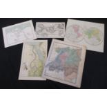
- Maps (82)
- Collectables (81)
- Sporting Memorabilia & Equipment (40)
- Stamps (34)
- Models, Toys, Dolls & Games (26)
- Arms, Armour & Militaria (21)
- Photographs (17)
- Ceramics (5)
- Classic Cars, Motorcycles & Automobilia (5)
- Musical Instruments & Memorabilia (5)
- Drawings & Pastels (4)
- Entertainment Memorabilia (4)
- Jewellery (4)
- Sculpture (4)
- Fine Art & Antiques (3)
- Scientific Instruments (3)
- Taxidermy & Natural History (3)
- Watercolours (2)
- Cameras & Camera Equipment (1)
- Carpets & Rugs (1)
- Chinese Works of Art (1)
- Ethnographica & Tribal Art (1)
- Kitchenalia (1)
- Russian Works of Art (1)
- Silver & Silver-plated items (1)
- Textiles (1)
Filtered by:
- Creator / Brand
- List
- Grid
This auctioneer has chosen to not publish their results. Please contact them directly for any enquiries.
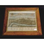

WILLIAM MAITLAND (PUBLISHED): A VIEW OF LONDON ABOUT THE YEAR 1560, engraved hand coloured view [
WILLIAM MAITLAND (PUBLISHED): A VIEW OF LONDON ABOUT THE YEAR 1560, engraved hand coloured view [1739], approx 310 x 470mm, bird's eye maple glaze...
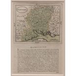
JOHN SELLER: HAMPSHIRE, engraved hand coloured map circa 1787, approx 120 x 140mm, text below and
JOHN SELLER: HAMPSHIRE, engraved hand coloured map circa 1787, approx 120 x 140mm, text below and verso, double glazed frame
THOMAS MOULE: CAMBRIDGESHIRE, engraved hand coloured map circa 1850, approx 260 x 200mm, framed
THOMAS MOULE: CAMBRIDGESHIRE, engraved hand coloured map circa 1850, approx 260 x 200mm, framed and glazed + 4 other hand coloured and engraved Mo...
T CLERK: PLAN OF THE CITY OF WASHINGTON, engraved hand coloured plan circa 1800, approx 210 x 260mm
T CLERK: PLAN OF THE CITY OF WASHINGTON, engraved hand coloured plan circa 1800, approx 210 x 260mm
PIETER VAN DEN KEERE: CORNWALLIA, engraved hand coloured map circa 1627, approx 80 x 120mm, framed
PIETER VAN DEN KEERE: CORNWALLIA, engraved hand coloured map circa 1627, approx 80 x 120mm, framed and glazed
AUSTRALASIA AND POLYNESIA - AFRICA, two hand coloured engraved maps in one frame, ex-Ewing's General
AUSTRALASIA AND POLYNESIA - AFRICA, two hand coloured engraved maps in one frame, ex-Ewing's General Atlas circa 1825, each approx 180 x 215mm, fr...
J RUSSELL: IRELAND DIVIDED INTO PROVINCES AND COUNTIES FROM THE BEST AUTHORITIES, engraved hand
J RUSSELL: IRELAND DIVIDED INTO PROVINCES AND COUNTIES FROM THE BEST AUTHORITIES, engraved hand coloured map, 1802, approx 400 x 315mm, framed and...
JOHN AND CHARLES WALKER: NORFOLK, engraved part hand coloured map circa 1862, approximately 320 x
JOHN AND CHARLES WALKER: NORFOLK, engraved part hand coloured map circa 1862, approximately 320 x 380mm, framed and glazed + F B BECKER: ENGLAND A...
THOMAS BOWEN: A NEW AND ACCURATE MAP OF ENGLAND, engraved hand coloured map circa 1770, approx 320 x
THOMAS BOWEN: A NEW AND ACCURATE MAP OF ENGLAND, engraved hand coloured map circa 1770, approx 320 x 220mm, framed and glazed
CHRISTOPHER CELLARIUS: GALLIA BELGICA, engraved hand coloured map circa 1744, approx 205 x 300mm
CHRISTOPHER CELLARIUS: GALLIA BELGICA, engraved hand coloured map circa 1744, approx 205 x 300mm
JOANNES BLAEU: LIONNOIS, FOREST, ET BEAUIOLOIS, engraved hand coloured map circa 1633, approx 370
JOANNES BLAEU: LIONNOIS, FOREST, ET BEAUIOLOIS, engraved hand coloured map circa 1633, approx 370 x 495mm, framed and glazed
HENRICUS HONDIUS: DOMINIUM VENETUM IN ITALIA, engraved hand coloured map circa 1627, approx 370 x
HENRICUS HONDIUS: DOMINIUM VENETUM IN ITALIA, engraved hand coloured map circa 1627, approx 370 x 500mm, framed and glazed
CHRISTOPHER CELLARIUS: AEGYPTUS ET CYRENAICA - AEGYPTI DELTA ET NILI OSTIA, 2 engraved hand coloured
CHRISTOPHER CELLARIUS: AEGYPTUS ET CYRENAICA - AEGYPTI DELTA ET NILI OSTIA, 2 engraved hand coloured maps circa 1729, each approx 200 x 300mm (2)
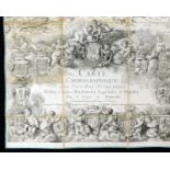
LOUIS-ANDRE DEPUIS: CARTE CHOROGRAPHE DES PAYS-BAS AUTRICHIENS..., 1777, large scale engraved
LOUIS-ANDRE DEPUIS: CARTE CHOROGRAPHE DES PAYS-BAS AUTRICHIENS..., 1777, large scale engraved dissected map, folding backed onto linen, 8 sections...
ORDNANCE SURVEY: NORFOLK (SOUTHERN DIVISION), L11,9,circa 1882, Wroxham, Rackheath etc, part hand
ORDNANCE SURVEY: NORFOLK (SOUTHERN DIVISION), L11,9,circa 1882, Wroxham, Rackheath etc, part hand coloured map, approx 660 x 960mm
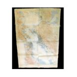
US GEOLOGICAL SURVEY: SAN FRANCISCO AND VICINITY, CALIFORNIA, large scale coloured map, 1915, backed
US GEOLOGICAL SURVEY: SAN FRANCISCO AND VICINITY, CALIFORNIA, large scale coloured map, 1915, backed onto linen, approx 1180 x 860mm
SET OF TWELVE MANUSCRIPT PEN, INK AND WATERCOLOUR MAPS by the cartographer RENE MIOT (b1895), maps
SET OF TWELVE MANUSCRIPT PEN, INK AND WATERCOLOUR MAPS by the cartographer RENE MIOT (b1895), maps mainly France including geological, textile ind...
THOMAS DUGDALE: SURREY, engraved map circa 1848, approx 180 x 230mm + SAMUEL NEELE: NORFOLK,
THOMAS DUGDALE: SURREY, engraved map circa 1848, approx 180 x 230mm + SAMUEL NEELE: NORFOLK, engraved hand coloured map circa 1819, approx 175 x 2...
C SMITH: A NEW MAP OF THE COUNTY OF LEICESTER, engraved hand coloured map, 1818, approx 435 x 490mm
C SMITH: A NEW MAP OF THE COUNTY OF LEICESTER, engraved hand coloured map, 1818, approx 435 x 490mm
![JOHN CARY: A MAP OF HARTFORDSHIRE [HERTFORDSHIRE] FROM THE BEST AUTHORITIES, engraved hand](https://portal-images.azureedge.net/auctions-2018/srkey10211/images/6f87d934-3c3d-4ad4-98bc-02ed69efa163.jpg?w=155&h=155)
JOHN CARY: A MAP OF HARTFORDSHIRE [HERTFORDSHIRE] FROM THE BEST AUTHORITIES, engraved hand coloured map, circa 1806, approx size 375 x 480mm
J D'ANVILLE: 2 hand coloured engraved maps, published R Laurie, 1821, GERMANY, FRANCE, ITALY, SPAIN,
J D'ANVILLE: 2 hand coloured engraved maps, published R Laurie, 1821, GERMANY, FRANCE, ITALY, SPAIN, BRITISH ISLES IN AN INTERMEDIATE CENTURY BETW...
Packet: five Suffolk hand coloured engraved maps comprising PIGOT, [1840], approx size 220 x
Packet: five Suffolk hand coloured engraved maps comprising PIGOT, [1840], approx size 220 x 350mm, R CREIGHTON, [1831], approx size 225 x 300mm; ...
PACKET: assorted mid to late 18th and 19th century topographical engraved prints, mainly Essex and
PACKET: assorted mid to late 18th and 19th century topographical engraved prints, mainly Essex and East Anglia interest
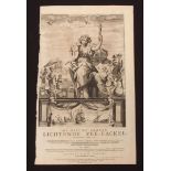
C J VOOGHT: DE NIEUWE GROOTE LICHTENDE ZEE-FACKEL..., engraved title page for atlas, 1687, printed
C J VOOGHT: DE NIEUWE GROOTE LICHTENDE ZEE-FACKEL..., engraved title page for atlas, 1687, printed area approx 490 x 290mm
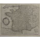
EMANUEL BOWEN: A NEW AND ACCURATE MAP OF FRANCE WITH ITS ACQUISITIONS COMPOSED FROM THE LATEST
EMANUEL BOWEN: A NEW AND ACCURATE MAP OF FRANCE WITH ITS ACQUISITIONS COMPOSED FROM THE LATEST SURVEYS, engraved map circa 1752, inset Harbour of ...
GALLIAE REGNUM IN OMNIS SUAS PROVINCIAS ACCURATE DIVISUM, engraved hand coloured map circa 1700
GALLIAE REGNUM IN OMNIS SUAS PROVINCIAS ACCURATE DIVISUM, engraved hand coloured map circa 1700 depicting Southern England from Lincolnshire coast...
J JANSSON: COMITATIS CANTABRIGIENSIS VERNACULE CAMBRIDGESHIRE, engraved map circa 1650, approx 400 x
J JANSSON: COMITATIS CANTABRIGIENSIS VERNACULE CAMBRIDGESHIRE, engraved map circa 1650, approx 400 x 505mm
NICHOLAS SANSON: ANCIENS ROYAUMES DE KENT, D'ESSEX, ET DE SUSSEX ON SONT AUJOURDHUI LES COMPTES DE
NICHOLAS SANSON: ANCIENS ROYAUMES DE KENT, D'ESSEX, ET DE SUSSEX ON SONT AUJOURDHUI LES COMPTES DE KENT, D'ESSEX, MIDDLESSEX, ET HARTFORD DE SUSSE...
THE BRITISH GAZETTEER: SUFFOLK, engraved map published H G Collins, circa 1852, approx 325 x 395mm +
THE BRITISH GAZETTEER: SUFFOLK, engraved map published H G Collins, circa 1852, approx 325 x 395mm + 2 Great Eastern Railway engraved maps circa 1...
PACKET: 19 Ordnance Survey East Anglia engraved maps, late 19th century, some hand coloured, various
PACKET: 19 Ordnance Survey East Anglia engraved maps, late 19th century, some hand coloured, various sheets including Norwich sheet 161, Great Yar...
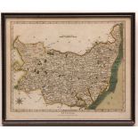
JOHN CARY: SUFFOLK, engraved part hand coloured map, 1805, approx 390 x 500mm
CHRISTOPHER SAXTON/WILLIAM KIP: SUFFOLCIE COMITATUS..., engraved hand coloured map circa 1610,
CHRISTOPHER SAXTON/WILLIAM KIP: SUFFOLCIE COMITATUS..., engraved hand coloured map circa 1610, approx 275 x 380mm, laid down on card + J JANSSON: ...
ROBERT MORDEN: 4 engraved maps, Buckinghamshire, Bedfordshire, Gloucestershire, Northumberland,
ROBERT MORDEN: 4 engraved maps, Buckinghamshire, Bedfordshire, Gloucestershire, Northumberland, all [1695], some faults (4)
ROBERT MORDEN: LEICESTERSHIRE, engraved map [1695], approx 355 x 420mm
J HARRISON (PUBLISHED): A NEW AND CORRECT MAP OF LEICESTER AND RUTLAND ENGRAVED FROM AN ACTUAL
J HARRISON (PUBLISHED): A NEW AND CORRECT MAP OF LEICESTER AND RUTLAND ENGRAVED FROM AN ACTUAL SURVEY WITH OTHER IMPROVEMENTS, engraved map, 1787,...
RICHARD BLOME: A MAPP OF THE COUNTY OF NORTHAMPTON WITH ITS HUNDREDS, engraved map circa 1673,
RICHARD BLOME: A MAPP OF THE COUNTY OF NORTHAMPTON WITH ITS HUNDREDS, engraved map circa 1673, approx 255 x 310mm + ROBERT DAWSON: NORTHAMPTONSHIR...
CHRISTOPHER SAXTON/WILLIAM KIP: HUNTINGDON COMITATUS..., engraved hand coloured map [1607], approx
CHRISTOPHER SAXTON/WILLIAM KIP: HUNTINGDON COMITATUS..., engraved hand coloured map [1607], approx 275 x 335mm
ROBERT MORDEN: NORTHAMPTONSHIRE, engraved map, [1695], approx 355 x 410mm
![JOHN SPEED: LEICESTER..., engraved map [1611], approx 375 x 500mm, some faults](https://portal-images.azureedge.net/auctions-2018/srkey10211/images/2b1502d7-100c-4280-9aae-85ed9ad098a9.jpg?w=155&h=155)
JOHN SPEED: LEICESTER..., engraved map [1611], approx 375 x 500mm, some faults
ROBERT MORDEN: BEDFORDSHIRE, engraved hand coloured map [1695], approx 315 x 395mm + JOHN CARY: A
ROBERT MORDEN: BEDFORDSHIRE, engraved hand coloured map [1695], approx 315 x 395mm + JOHN CARY: A MAP OF NORTHAMPTONSHIRE FROM THE BEST AUTHORITIE...
R MORDEN: LINCOLNSHIRE, engraved hand coloured map, circa 1738, approx 360 x 420mm
JOHN STOCKDALE (PUBLISHED): A MAP OF THE ROADS OF SPAIN/INDEX TO MENTELLE'S NINE SHEET MAP, engraved
JOHN STOCKDALE (PUBLISHED): A MAP OF THE ROADS OF SPAIN/INDEX TO MENTELLE'S NINE SHEET MAP, engraved hand coloured map, 1808, approx 395 x 465mm
JOANNES BLAEU: LEICESTRENSIS COMITATUS, engraved hand coloured map, circa 1662, approx 370 x
JOANNES BLAEU: LEICESTRENSIS COMITATUS, engraved hand coloured map, circa 1662, approx 370 x 485mm, German text verso
ROBERT MORDEN: LEICESTERSHIRE, engraved map [1695], approx 360 x 415mm + CHARLES SMITH: A NEW MAP OF
ROBERT MORDEN: LEICESTERSHIRE, engraved map [1695], approx 360 x 415mm + CHARLES SMITH: A NEW MAP OF THE COUNTY OF NORTHAMPTON DIVIDED INTO HUNDRE...
JOANNES BLAEU: LEICESTRENSIS COMITATUS, engraved hand coloured map, circa 1662, approx 380 x
JOANNES BLAEU: LEICESTRENSIS COMITATUS, engraved hand coloured map, circa 1662, approx 380 x 490mm, some browning, marginal repair, French text ve...
A HUGE LARGE-SCALE LATE VICTORIAN ORDNANCE SURVEY MAP - STRATTON STRAWLESS AREA, varnished, faults
A HUGE LARGE-SCALE LATE VICTORIAN ORDNANCE SURVEY MAP - STRATTON STRAWLESS AREA, varnished, faults
BOX: good quantity, mainly WWII period Ordnance Survey maps
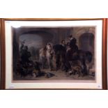
JAMES SCOTT AFTER FREDERICK TAYLER: SPORTSMEN HALTING AT A HIGHLAND BOTHIE, hand coloured steel
JAMES SCOTT AFTER FREDERICK TAYLER: SPORTSMEN HALTING AT A HIGHLAND BOTHIE, hand coloured steel engraving, published 1856, approx 515 x 830mm, fra...
SAMUEL COUSINS AFTER SIR EDWIN LANDSEER: RETURN FROM HAWKING, hand coloured mezzotint, circa 1840,
SAMUEL COUSINS AFTER SIR EDWIN LANDSEER: RETURN FROM HAWKING, hand coloured mezzotint, circa 1840, approx 560 x 860mm, framed and glazed
JEAN-BAPTISTE MICHEL & WILLIAM LENEY AFTER WILLIAM MILLER: SHAKESPEARE, THIRD PART OF KING HENRY THE
JEAN-BAPTISTE MICHEL & WILLIAM LENEY AFTER WILLIAM MILLER: SHAKESPEARE, THIRD PART OF KING HENRY THE SIXTH, ACT IV SCENE V, hand coloured engravin...
![C HUNT AFTER G B CAMPION: AD MONTEM [ETON COLLEGE TRIENNIAL CEREMONY], hand coloured aquatint](https://portal-images.azureedge.net/auctions-2018/srkey10211/images/ee092534-99ed-4745-b5bb-14272db0947a.jpg?w=155&h=155)
C HUNT AFTER G B CAMPION: AD MONTEM [ETON COLLEGE TRIENNIAL CEREMONY], hand coloured aquatint
C HUNT AFTER G B CAMPION: AD MONTEM [ETON COLLEGE TRIENNIAL CEREMONY], hand coloured aquatint published Ackermann 1838, approx 390 x 560mm, framed...
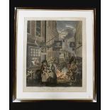
WILLIAM HOGARTH: FOUR TIMES OF THE DAY, MORNING, NOON, EVENING, NIGHT, set of four hand coloured
WILLIAM HOGARTH: FOUR TIMES OF THE DAY, MORNING, NOON, EVENING, NIGHT, set of four hand coloured engraved prints, Evening engraved by Bernard Bart...
WILLIAM WALCOT, original etching, Cathedral? Interior, signed in pencil, early 20th century,
WILLIAM WALCOT: THE BATHS OF CARACALLA - THE CALDARIUM, 1915, original etching, signed in pencil, approx 440 x 380mm, framed and glazed ...[more]
F P SOIRON & T GAUGAIN AFTER EDWARD DAYES: THE PROMENADE IN ST JAMES PARK - AN AIRING IN HYDE
F P SOIRON & T GAUGAIN AFTER EDWARD DAYES: THE PROMENADE IN ST JAMES PARK - AN AIRING IN HYDE PARK, 2 coloured engravings, re-strikes, approx 360 ...
J MAJOR AFTER ANTONIO JOLI: 3 coloured engraved prints: A GENERAL VIEW OF THE RUINED CITY OF PASTUM,
J MAJOR AFTER ANTONIO JOLI: 3 coloured engraved prints: A GENERAL VIEW OF THE RUINED CITY OF PASTUM, approx 260 x 390mm; A VIEW OF THREE TEMPLES T...
J BASIRE AFTER P CROCKER: VIEW OF STONEHENGE/CAMP NEAR AMESBURY, engraved view and plan on one
J BASIRE AFTER P CROCKER: VIEW OF STONEHENGE/CAMP NEAR AMESBURY, engraved view and plan on one sheet, published W Miller, 1811, approx 455 x 295mm...
AFTER J WALTER: SS GREAT BRITAIN OF BRISTOL BEING WARPED OUT OF AVON DOCK 24.1.1845, coloured print,
AFTER J WALTER: SS GREAT BRITAIN OF BRISTOL BEING WARPED OUT OF AVON DOCK 24.1.1845, coloured print, published Ariel Press, 20th century, approx 3...
ANTIQUE hand coloured engraved ornithological print CRESTED QUETZAL?, late 18th/early 19th century, approx 225 x 165mm, framed and glazed
SPINNING, hand coloured mezzotint circa 1820, approx 450 x 350mm, old glazed frame
LOUIS HAGHE AFTER DAVID ROBERTS: RUINS OF LUXOR FROM THE SOUTH WEST, coloured litho, circa 1849,
LOUIS HAGHE AFTER DAVID ROBERTS: RUINS OF LUXOR FROM THE SOUTH WEST, coloured litho, circa 1849, approx 245 x 345mm, framed and glazed + 2 other c...