Filtered by:
- Category,
- Item Type
- List
- Grid
A subscription to the Price Guide is required to view results for auctions ten days or older. Click here for more information
![[MAPS] LIZARS (W.) engraver: Map of the Firth of Clyde and Western Highlands of Scotland...for the](https://portal-images.azureedge.net/auctions-2019/srjo10251/images/faadac6d-a629-4b0b-95ca-ab0900f33ba8.jpg?w=155&h=155)

[MAPS] LIZARS (W.) engraver: Map of the Firth of Clyde and Western Highlands of Scotland...for the
[MAPS] LIZARS (W.) engraver: Map of the Firth of Clyde and Western Highlands of Scotland...for the Strangers Guide or Steamboat Companion..., [etc...
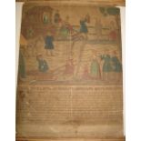
RUSSIAN BROADSIDE, h-col'd wood engraved agricultural scene above printed text, 18th /19th c.,
RUSSIAN BROADSIDE, h-col'd wood engraved agricultural scene above printed text, 18th /19th c., laid on card, damage, 17 x 12 inches.
![[MAPS] q. of large scale maps of INDIAN OCEAN ISLANDS, incl. Cocos or Keeling Islands, Chagos](https://portal-images.azureedge.net/auctions-2019/srjo10251/images/e1f16549-4f6d-4454-b65e-ab0900f35c89.jpg?w=155&h=155)
[MAPS] q. of large scale maps of INDIAN OCEAN ISLANDS, incl. Cocos or Keeling Islands, Chagos
[MAPS] q. of large scale maps of INDIAN OCEAN ISLANDS, incl. Cocos or Keeling Islands, Chagos Archipelago, Solomon Islands etc; & a few U. K. coas...
BOSSILI (C.) The War in Italy, 4to, pictorial title & 39 of 40 col. plates, 2 maps, loose in binding, L., 1859 (as a collection of plates). ...[m...
![[TOPOGRAPHY] LEWIS (F. C.) a disbound collection of topographical plates, incl. Devon rivers (Q).](https://portal-images.azureedge.net/auctions-2019/srjo10251/images/61c81863-2551-4977-bc00-ab0900f36100.jpg?w=155&h=155)
[TOPOGRAPHY] LEWIS (F. C.) a disbound collection of topographical plates, incl. Devon rivers (Q).
[TOPOGRAPHY] LEWIS (F. C.) a disbound collection of topographical plates, incl. Devon rivers (Q).
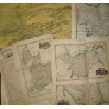
![[MAPS / RIGHTS of WAY] coll'n of HAMPSHIRE maps relating to public rights of way as per the 1949 Act](https://portal-images.azureedge.net/auctions-2019/srjo10251/images/5b7675cc-6e5a-4da9-ae36-ab0900f36691.jpg?w=155&h=155)
[MAPS / RIGHTS of WAY] coll'n of HAMPSHIRE maps relating to public rights of way as per the 1949 Act
[MAPS / RIGHTS of WAY] coll'n of HAMPSHIRE maps relating to public rights of way as per the 1949 Act of Parliament, 1930's-1960's (Q).
![[MAP] JANSON (J.) [Warwickshire] Wigorniensis..., h-col'd engr. map, 19 x 23 inches [S] central](https://portal-images.azureedge.net/auctions-2019/srjo10251/images/0bcb2d4d-cf9f-43f9-81d2-ab0900f36cb0.jpg?w=155&h=155)
[MAP] JANSON (J.) [Warwickshire] Wigorniensis..., h-col'd engr. map, 19 x 23 inches [S] central
[MAP] JANSON (J.) [Warwickshire] Wigorniensis..., h-col'd engr. map, 19 x 23 inches [S] central fold, f. & g., text showing verso, Amsterdam, 17th...
![[MAPS] misc. maps, 17th - 19th c., of Moscow, Boston, Natal, Cape Colony, u/f or mounted (6).](https://portal-images.azureedge.net/auctions-2019/srjo10251/images/ed315cbc-c3b3-4f87-8104-ab0900f36db7.jpg?w=155&h=155)
[MAPS] misc. maps, 17th - 19th c., of Moscow, Boston, Natal, Cape Colony, u/f or mounted (6).
[MAPS] misc. maps, 17th - 19th c., of Moscow, Boston, Natal, Cape Colony, u/f or mounted (6).
![[MAPS] STANFORD'S Chart of the Thames Estuary, col. folding map, linen backed, cloth covers with](https://portal-images.azureedge.net/auctions-2019/srjo10251/images/3d3a9e8c-105a-469c-b101-ab0900f36e7a.jpg?w=155&h=155)
[MAPS] STANFORD'S Chart of the Thames Estuary, col. folding map, linen backed, cloth covers with
[MAPS] STANFORD'S Chart of the Thames Estuary, col. folding map, linen backed, cloth covers with separate line map of the Thames folding into clot...
MAPS, small coll'n misc., 19th c. (Q).
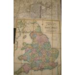
MAPS, Pigot & Co folding map of England & Wales, 1840, cloth covers; Bacon's map of Birmingham,
MAPS, Pigot & Co folding map of England & Wales, 1840, cloth covers; Bacon's map of Birmingham, printed on linen (2). ...[more]
BARROW (John) Travels into the Interior of Southern Africa, 2 vols, 4to, 8 hand-col'd aquatint
BARROW (John) Travels into the Interior of Southern Africa, 2 vols, 4to, 8 hand-col'd aquatint plates, 9 folding maps (some large, hand-col'd), cl...
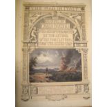
![[LONDON ATLAS, etc.] The Authentic Map Directory of London and Suburbs. Fourth Edition, 4to, col.](https://portal-images.azureedge.net/auctions-2019/srjo10251/images/f7c491c3-3253-43e2-be42-ab0900f39e99.jpg?w=155&h=155)
[LONDON ATLAS, etc.] The Authentic Map Directory of London and Suburbs. Fourth Edition, 4to, col.
[LONDON ATLAS, etc.] The Authentic Map Directory of London and Suburbs. Fourth Edition, 4to, col. maps, clo., L., "Geographic" Ltd, n.d.; & 2 book...
![[TOPOGRAPHY etc.] A Guide to the Watering and Sea Bathing Places..., 12mo, folding frontis of](https://portal-images.azureedge.net/auctions-2019/srjo10251/images/e9d49bee-68a3-46be-be0e-ab0900f39fd6.jpg?w=155&h=155)
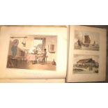
[TOPOGRAPHY etc.] A Guide to the Watering and Sea Bathing Places..., 12mo, folding frontis of
[TOPOGRAPHY etc.] A Guide to the Watering and Sea Bathing Places..., 12mo, folding frontis of Brighton Pavilion, engr. pict. t.p., 23 plates (with...
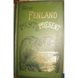
MILLER & SKERTCHLY, The Fenland Past and Present, lge 8vo, plates & maps, cloth gilt, Wisbech,
MILLER & SKERTCHLY, The Fenland Past and Present, lge 8vo, plates & maps, cloth gilt, Wisbech, 1878. ...[more]
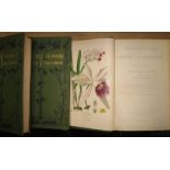
STEPP (E.) Favourite Flowers, 4 vols, 8vo, 316 col. plates, cloth gilt, L., 1897 (4).
DORSET Natural History & Antiquarian Field Club Proceedings, 32 vols, 8vo, plates, maps, cloth,
DORSET Natural History & Antiquarian Field Club Proceedings, 32 vols, 8vo, plates, maps, cloth, Dorchester, 1891, 1895, 1898-1927 (32). ...[more]
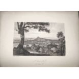
HAKEWILL (J.) Series of Views of the Neighbourhood of WINDSOR, 4to, plates, half morocco, L., 1820.
HAKEWILL (J.) Series of Views of the Neighbourhood of WINDSOR, 4to, plates, half morocco, L., 1820.

ERASMUS, Moriae Encomium, 12mo, contemp. calf (rebacked), Oxoniae, Typis. W. Hall, 1668.
![[MAPS] BROOKES (R.) The General Gazetteer..., 8vo, double hemisphere folding frontis., & 7 folding](https://portal-images.azureedge.net/auctions-2019/srjo10251/images/73448f33-3eec-4483-b655-ab0900f3d3e6.jpg?w=155&h=155)
[MAPS] BROOKES (R.) The General Gazetteer..., 8vo, double hemisphere folding frontis., & 7 folding
[MAPS] BROOKES (R.) The General Gazetteer..., 8vo, double hemisphere folding frontis., & 7 folding maps, calf (worn), 13th edition, L., 1807; & 2 ...
TOPOGRAPHY & MAPS, q. of repro maps incl. ROCQUE'S 1746 Survey of London, with introduction by
TOPOGRAPHY & MAPS, q. of repro maps incl. ROCQUE'S 1746 Survey of London, with introduction by Howgego, 1971; Methode...pour apprendre La Geograph...
GORDON (P.) Geography Anatomiz'd...Thirteenth Edition, 8vo 15 folding maps (incl. N. America showing
GORDON (P.) Geography Anatomiz'd...Thirteenth Edition, 8vo 15 folding maps (incl. N. America showing California as an Island), calf (upr. cvr. off...
![[IRELAND] [BUSH (J.)] Hibernia Curiosa, 8vo, 6 folding maps, plates and plans, calf, bookplate of](https://portal-images.azureedge.net/auctions-2019/srjo10251/images/8f4cb303-0036-4502-b7bf-ab0900f40e71.jpg?w=155&h=155)
[IRELAND] [BUSH (J.)] Hibernia Curiosa, 8vo, 6 folding maps, plates and plans, calf, bookplate of
[IRELAND] [BUSH (J.)] Hibernia Curiosa, 8vo, 6 folding maps, plates and plans, calf, bookplate of the Earl of Chichester, L., 1769.
![[AFRICA] HERTSLET (Sir E.) The Map of Africa by Treaty...with numerous Maps, 2 vols., 8vo,](https://portal-images.azureedge.net/auctions-2019/srjo10251/images/91eed575-c1d7-4326-87b7-ab0900f411bb.jpg?w=155&h=155)
[AFRICA] HERTSLET (Sir E.) The Map of Africa by Treaty...with numerous Maps, 2 vols., 8vo, folding, double-up & other maps as called for, cloth, L...