Filtered by:
- Category,
- Creator / Brand
- List
- Grid
This auctioneer has chosen to not publish their results. Please contact them directly for any enquiries.
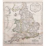

Robert de Vaugondy (1688-1766) French. "L'Angleterre", Map, 9.5" x 8.75".
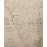
After Major James Rennell (1742-1830) British. "The Peninsula of India", Map, Unframed, 19" x 17",
After Major James Rennell (1742-1830) British. "The Peninsula of India", Map, Unframed, 19" x 17", and Ten other various Maps of the World by othe...
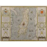
John Speed (1552-1629) British. "The Isle of Man, 1610", Map, Described by Tho Durham Ano 1595,
John Speed (1552-1629) British. "The Isle of Man, 1610", Map, Described by Tho Durham Ano 1595, Double Glazed showing both sides of Map, 15" x 19....
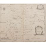
19th Century English School. "Comitatus Rotelandiae, Tabula Nova & Aucta", Map, Unframed, 11.25" x
19th Century English School. "Comitatus Rotelandiae, Tabula Nova & Aucta", Map, Unframed, 11.25" x 14.25", and Six other various Maps of the UK, S...
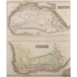
19th Century English School. "North Africa/ South Africa", Map, Drawn and Engraved for Thomson's New
19th Century English School. "North Africa/ South Africa", Map, Drawn and Engraved for Thomson's New General Atlas 1815, Unframed, 23" x 20.25", a...
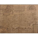
John Speed (1552-1629) British after John Norden (c.1546/48-c.1626) British. "Sussex", Map, 15.25" x
John Speed (1552-1629) British after John Norden (c.1546/48-c.1626) British. "Sussex", Map, 15.25" x 20.25".