
Filtered by:
- Category
- List
- Grid
A subscription to the Price Guide is required to view results for auctions ten days or older. Click here for more information
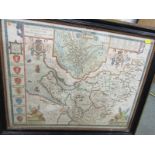

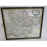
JOHN SPEED, 17th Century hand coloured engraved map "The Countye Palatine of Chester", double
JOHN SPEED, 17th Century hand coloured engraved map "The Countye Palatine of Chester", double glazed, 41cm x 51cm
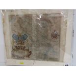
Early 17th Century hand coloured map of the county of Derbyshire, by or after, Saxton, unframed,
Early 17th Century hand coloured map of the county of Derbyshire, by or after, Saxton, unframed, 29cm x 32cm
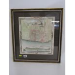
Antique hand coloured street map, published 1779, of Brighthelmstone original name of Brighton 34
Antique hand coloured street map, published 1779, of Brighthelmstone original name of Brighton 34 x 30cm
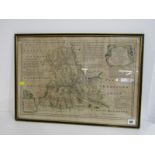
Hand coloured antique map of Brecknockshire by Thomas Kitchin, late 17th/early 18th Century , 39 x
Hand coloured antique map of Brecknockshire by Thomas Kitchin, late 17th/early 18th Century , 39 x 55 cm
17th Century hand coloured antique map of Essex by Robert Morden, published 1695 with good colouring
17th Century hand coloured antique map of Essex by Robert Morden, published 1695 with good colouring and almost as new condition, 35cm x 42 cm
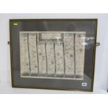
Hand coloured antique road map of the route from Carlisle to Berwick-upon-Tweed by John Ogilby
Hand coloured antique road map of the route from Carlisle toBerwick-upon-Tweed by John Ogilby published c1675, 33cm x 45 cm
* Thank you for you Valued Custom * END OF SALE