Filtered by:
- Category,
- Item Type
- List
- Grid
A subscription to the Price Guide is required to view results for auctions ten days or older. Click here for more information
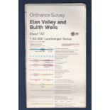

Elan Valley and Builth Wells Ordnance Survey: Sheet 147 1:50 000 Landranger Series
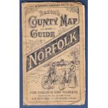
Map - Bacons Norfolk County Map and Guide for Cyclists and Tourists, in waterproof cover. Well
Map - Bacons Norfolk County Map and Guide for Cyclists and Tourists, in waterproof cover. Well used.
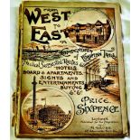
From West to East a Compendium of European Travel, published by H. Grube 1895 - 96. Some wear and
From West to East a Compendium of European Travel, published by H. Grube 1895 - 96. Some wear and tear to the cover, all maps and pages intact. Sc...
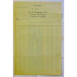
New York USA A. J. Pagani Inc engraved heading Blank Statement Form
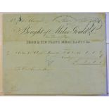
London 1859 Miles Gould & Co engraved heading Iron & Tinplate Merchants
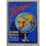
Libby's Modern World Atlas-New Edition-Lovely period piece with advertising for Libby's products.
Libby's Modern World Atlas-New Edition-Lovely period piece with advertising for Libby's products.
Antique Maps - 1828 Map from 'Encyclopaedia Londinensis' with many misspellings e.g. Hawkstead/
Antique Maps - 1828 Map from 'Encyclopaedia Londinensis' with many misspellings e.g. Hawkstead/Harkstead, Nedham/Needham, Eastrohoel/East Bergholt...
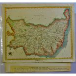
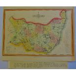
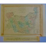
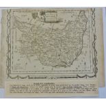
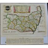
Suffolk 1787-A map of Suffolk by John Cary, from the 'New and Correct Atlas' (26cmx22cm) very fine.
Suffolk 1787-A map of Suffolk by John Cary, from the 'New and Correct Atlas' (26cmx22cm) very fine.
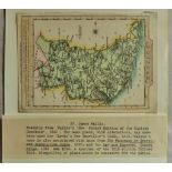
Antique Maps - 1787 Map from English Atlas or Concise View of England and Wales, 13cmx12cm, very
Antique Maps - 1787 Map from English Atlas or Concise View of England and Wales, 13cmx12cm, very fine(page 37)

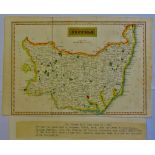
Antique Maps - 1807 Map from 'Universal Magazine' the Laurie and Whittles New and Improved Atlas
Antique Maps - 1807 Map from 'Universal Magazine' the Laurie and Whittles New and Improved Atlas 24cmx18cm very fine, some edge paper toned.
Antique Maps - 1810 Map from Wallis 'New Edition of the English Counties' miniature, 12cmx14cm,
Antique Maps - 1810 Map from Wallis 'New Edition of the English Counties' miniature, 12cmx14cm,very fine, with excessive misspelling for the perio...
Antique Maps - 1812 map from 'New and Improved County Atlas, 26x18mm, very fine, hundreds listed
Antique Maps - 1812 map from 'New and Improved County Atlas, 26x18mm, very fine, hundreds listed inset.
Antique Maps - 1818 Map from 'Excursions through Suffolk' very fine, folding crease.
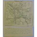
Antique Maps - 1817 Map Ipswich Town, from Excursions in Suffolk' folding crease, very fine.
Antique Maps - 1817 Map Ipswich Town, from Excursions in Suffolk' folding crease, very fine.
Antique Maps - 1834 Map from the 'New British Atlas' very fine. 24cmx19cm.
Antique Maps - 1846 Map from 'parliamentary Gazetteer of England and Wales'24cmx19cm, very fine,
Antique Maps - 1846 Map from 'parliamentary Gazetteer of England and Wales'24cmx19cm, very fine, some toning.
Antique Maps - 1830 Small maps from S.Leighs 'New Atlas of England and Wales,12cmx19cm.
Antique Maps - 1759 Miniature map from 'New and Accurate Maps of Countries of England and Wales',
Antique Maps - 1759 Miniature map from 'New and Accurate Maps of Countries of England and Wales',12cmx8cm,very fine, scarce.
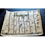
Antique Map - Yorkshire John Ogilby - the road from York to Lancaster, evenly toned, edges worn at
Antique Map - Yorkshire John Ogilby - the road from York to Lancaster, evenly toned, edges worn at right but intact for framing. Approx 19" x 14...
Antique Map - Yorkshire - West Riding 1610 John Speede. The West Ridinge of Yorkshire with the
Antique Map - Yorkshire - West Riding 1610 John Speede. The West Ridinge of Yorkshire with the most famous and fayre Citie Yorke described 1610....
Chart of the World on Mercator's projection
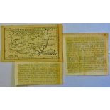
A Map of Northamptonshire Engraved from an actual survey with improvements
Second Map of Northamptonshire Engraved from an actual survey with improvements
A Map of Isola Dimcelta Early 1800's-very detailed - ny Apud John. It-Cornel Blasu on Vellum
A Map of Isola Dimcelta Early 1800's-very detailed - ny Apud John. It-Cornel Blasu on Vellum
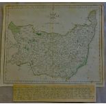
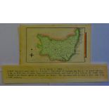
A Map of East Anglia-Mill aria Angelica Magna-Sumptibus Henrici Hondy-Written in Latin - on vellum
A Map of East Anglia-Mill aria Angelica Magna-Sumptibus Henrici Hondy-Written in Latin - on vellum and water coloured 1800 early
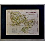
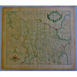
Antique Map-Denbighshire drawn & engraved by J Archer -Pentonville London
Map-Surrey Circa 1834 by Archibald Fullertan Glasgow

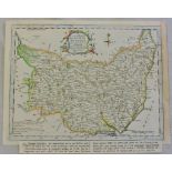
Antique Maps - England, Hermannides,1661 Map and Cartouches 'Britannia Saxonica' from Britannia
Antique Maps - England, Hermannides,1661 Map and Cartouches 'Britannia Saxonica' from Britannia Magna(Amsterdam) engraved by M Burghers. A rare co...
Antique Maps - 1769 map from New British Traveller(1784)embellished surrounds, published by Alexander Hogg, 21cmx16cm, very fine, some page edge t...
Antique Maps - 1966 Map from Elliss English Atlas(copied from Kitchins map of 1764)25cmx19cm, very
Antique Maps - 1966 Map from Elliss English Atlas(copied from Kitchins map of 1764)25cmx19cm, very fine.
Antique Maps - 1769 map from 'England Displayed'(Previously small British Atlas)20cmx16cm, very
Antique Maps - 1769 map from 'England Displayed'(Previously small British Atlas)20cmx16cm, very fine.
Antique Maps - 1764 map from 'England Illustrated'26mm x 19mm, very fine.
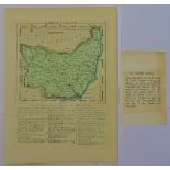
Antique Maps - 1759 Map from 'General magazines of Arts and Science/The Natural History of England, Hundreds inset, Borough Towns, Market Towns an...
Antique Maps - 1719 Road Map - Kings Lynn to Harwich from 'Principle Roads of England and Wales'
Antique Maps - 1719 Road Map - Kings Lynn to Harwich from 'Principle Roads of England and Wales' reduced from Ogiby, 22cm x 15cm uncoloured, edge ...

Antique Maps - 1719 Road Map - Kings Lynn to Harwich from 'Principle Roads of England and Wales'
Antique Maps - 1719 Road Map - Kings Lynn to Harwich from 'Principle Roads of England and Wales' reduced from Ogiby, 22cm x 15cm uncoloured, edge ...
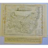
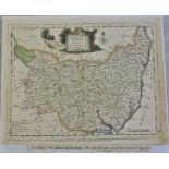
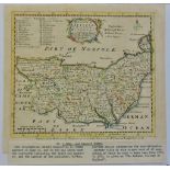
Antique Maps - Suffolk,Taylor-Blome,1715 map from 'England Exactly Described' decorative with Lord
Antique Maps - Suffolk,Taylor-Blome,1715 map from 'England Exactly Described' decorative with Lord Cornwallis Arms and Hundreds in Suffolk inset.2...
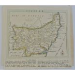
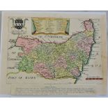
Antique Maps - Suffolk Blome, R1693 Map from ' Cosmography' decorative, dedicated to Charles, Lord
Antique Maps - Suffolk Blome, R1693 Map from ' Cosmography' decorative, dedicated to Charles, Lord Cornwallis, Baron of Eyr (Arm Inset) Hundred of...
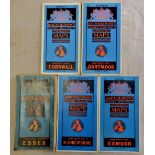
Cornwall-Dartmoor -Exmoor-North Shropshire-Essex-Bartholomew's revised half-inch maps all cloth
Cornwall-Dartmoor -Exmoor-North Shropshire-Essex-Bartholomew's revised half-inch maps all cloth other than Cornwall(paper)

Great Britain-ordnance survey - large quantity mainly covering England and Wales in 2 books
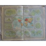
Mapping of the World Plate 1 The Times Survey Atlas of the World prepared by Edinburgh Geographical Institute under direction of John Bartholomew...
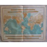
World Bathy Orographical Plate 2 The Times Survey Atlas of the World prepared by Edinburgh Geographical Institute under direction of John Barthol...
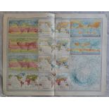
World Climate Plate 3 The Times Survey Atlas of the World prepared by Edinburgh Geographical
World Climate Plate 3 The Times Survey Atlas of the World prepared by Edinburgh Geographical Institute under direction of John Bartholomew 1920 2...
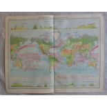
World Vegetation and Ocean Currents Plate 4 The Times Survey Atlas of the World prepared by Edinburgh Geographical Institute under direction of J...
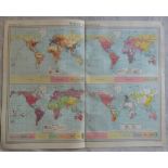
World Population Races Religions and Languages Plate 5 The Times Survey Atlas of the World prepared by Edinburgh Geographical Institute under dir...
World Commercial Development Occupations and Means of Traffic Plate 6 The Times Survey Atlas of
World Commercial Development Occupations and Means of Traffic Plate 6 The Times Survey Atlas of the World prepared by Edinburgh Geographical Inst...
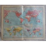
World Political Plate 7 The Times Survey Atlas of the World prepared by Edinburgh Geographical
World Political Plate 7 The Times Survey Atlas of the World prepared by Edinburgh Geographical Institute under direction of John Bartholomew 1920...
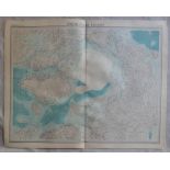
North Polar Regions Plate 8 The Times Survey Atlas of the World prepared by Edinburgh Geographical
North Polar Regions Plate 8 The Times Survey Atlas of the World prepared by Edinburgh Geographical Institute under direction of John Bartholomew ...
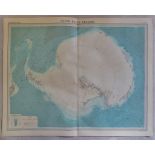
South Polar Regions Plate 9 The Times Survey Atlas of the World prepared by Edinburgh Geographical
South Polar Regions Plate 9 The Times Survey Atlas of the World prepared by Edinburgh Geographical Institute under direction of John Bartholomew ...
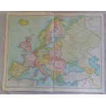
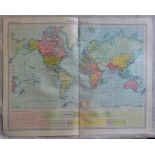
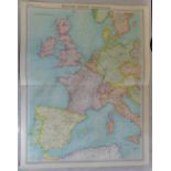
Europe Political Plate 10 The Times Survey Atlas of the World prepared by Edinburgh Geographical
Europe Political Plate 10 The Times Survey Atlas of the World prepared by Edinburgh Geographical Institute under direction of John Bartholomew 19...
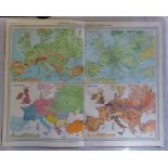
Europe Orography Vegetation Population Races Plate 11 The Times Survey Atlas of the World prepared
Europe Orography Vegetation Population Races Plate 11 The Times Survey Atlas of the World prepared by Edinburgh Geographical Institute under dire...
Western Europe Communications Plate 12 The Times Survey Atlas of the World prepared by Edinburgh
Western Europe Communications Plate 12 The Times Survey Atlas of the World prepared by Edinburgh Geographical Institute under direction of John B...
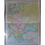
Eastern Europe Communications Plate 13 The Times Survey Atlas of the World prepared by Edinburgh
Eastern Europe Communications Plate 13 The Times Survey Atlas of the World prepared by Edinburgh Geographical Institute under direction of John B...
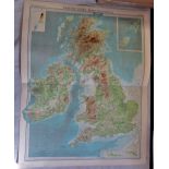
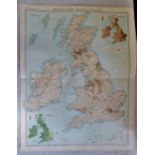
British Isles Bathy Orographical Plate 14 The Times Survey Atlas of the World prepared by Edinburgh Geographical Institute under direction of Joh...
British Isles Vegetation and Climate Plate 15 The Times Survey Atlas of the World prepared by
British Isles Vegetation and Climate Plate 15 The Times Survey Atlas of the World prepared by Edinburgh Geographical Institute under direction of...
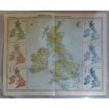
British Isles Railways and Industries Plate 16 The Times Survey Atlas of the World prepared by
British Isles Railways and Industries Plate 16 The Times Survey Atlas of the World prepared by Edinburgh Geographical Institute under direction o...
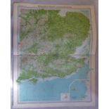
England and Wales SE Section Plate 18 The Times Survey Atlas of the World prepared by Edinburgh
England and Wales SE Section Plate 18 The Times Survey Atlas of the World prepared by Edinburgh Geographical Institute under direction of John Ba...
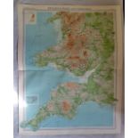
England and Wales SW Section Plate 19 The Times Survey Atlas of the World prepared by Edinburgh
England and Wales SW Section Plate 19 The Times Survey Atlas of the World prepared by Edinburgh Geographical Institute under direction of John Ba...
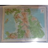
England and Wales N Section Plate 20 The Times Survey Atlas of the World prepared by Edinburgh
England and Wales N Section Plate 20 The Times Survey Atlas of the World prepared by Edinburgh Geographical Institute under direction of John Bar...
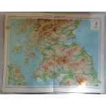
Scotland Southern Section Plate 21 The Times Survey Atlas of the World prepared by Edinburgh
Scotland Southern Section Plate 21 The Times Survey Atlas of the World prepared by Edinburgh Geographical Institute under direction of John Barth...
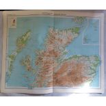
Scotland Northern Section Plate 22 The Times Survey Atlas of the World prepared by Edinburgh
Scotland Northern Section Plate 22 The Times Survey Atlas of the World prepared by Edinburgh Geographical Institute under direction of John Barth...