Filtered by:
- Category,
- Item Type
4 items
- List
- Grid
A subscription to the Price Guide is required to view results for auctions ten days or older. Click here for more information
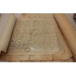

Lot 523
Ordnance Survey of Great Britain, Second War Revision 1941 sheet twelve, England, South East and
Ordnance Survey of Great Britain, Second War Revision 1941 sheet twelve, England, South East and London, Military Edition 76 x 100cm, together wit...
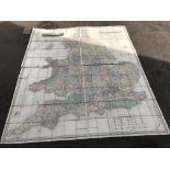
Lot 527
A map of England and Wales divided into counties, parliamentary divisions and dioceses, drawn by R
A map of England and Wales divided into counties, parliamentary divisions and dioceses, drawn by R Creighton, engraved by J Dower, published by S ...
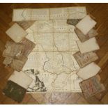
Lot 528
A New Map of the County of Essex, printed for C Smith, London, 1804, 48 x 53cm, cloth backed,
A New Map of the County of Essex, printed for C Smith, London, 1804, 48 x 53cm, cloth backed, together with an accurate map of the County Palatine...

Lot 892
A 20th century reconstituted garden figure of Atlas holding the world upon his shoulders, raised
A 20th century reconstituted garden figure of Atlas holding the world upon his shoulders, raised on square base, 90cm high