Filtered by:
- Sale Section,
- Creator / Brand
- List
- Grid
A subscription to the Price Guide is required to view results for auctions ten days or older. Click here for more information
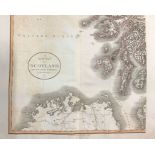

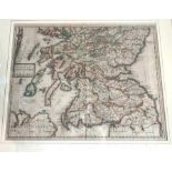
British Isles. Collection of hand-coloured, copper-engraved maps, comprising: Scotland, on four
British Isles. Collection of hand-coloured, copper-engraved maps, comprising: Scotland, on four separate folding sheets, John Cary, 1801, well-pre...
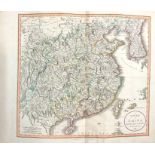
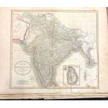
Collection of nine hand-coloured, copper-engraved, folding maps, comprising: China, John Cary, 1801;
Collection of nine hand-coloured, copper-engraved, folding maps, comprising: China, John Cary, 1801; America, John Thomson, n.d.; Hindoostan, John...
Cary, John. Collection of 25 hand-coloured, copper-engraved, folding maps, comprising: A New Chart
Cary, John. Collection of 25 hand-coloured, copper-engraved, folding maps, comprising: A New Chart of the World, 1801; A New Map of Europe, 1804; ...
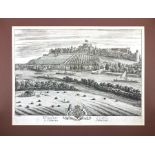
Kip & Knyff. An early-18th century bird's-eye prospect of Windsor Castle, uncoloured copper-
Kip & Knyff. An early-18th century bird's-eye prospect of Windsor Castle, uncoloured copper-engraving on laid/chain-lined paper, mounted/unframed,...
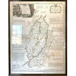
Nottinghamshire. Two hand-coloured, copper-engraved county maps on laid/chain-lined paper: Emanuel
Nottinghamshire. Two hand-coloured, copper-engraved county maps on laid/chain-lined paper: Emanuel Bowen, undated [18th-century], 74cm by 56cm; Ro...
![Morden, Robert. Collection of 20 maps, [1695 or later], ten mounted in printseller's wrappers: North](https://portal-images.azureedge.net/auctions-2022/hanson10442/images/d62b6246-6f77-45ee-bf6f-aec500e5a068.jpg?w=155&h=155)
Morden, Robert. Collection of 20 maps, [1695 or later], ten mounted in printseller's wrappers: North
Morden, Robert. Collection of 20 maps, [1695 or later], ten mounted in printseller's wrappers: North Wales; Derbyshire; Buckinghamshire; North Rid...
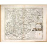
Miscellaneous collection of maps to include Essex, hand-coloured copper engraving by John Gibson &
Miscellaneous collection of maps to include Essex, hand-coloured copper engraving by John Gibson & Emanuel Bowen, London: John Bowles, 1778; Cambr...
Miscellaneous collection of maps by John Cary, Samuel Lewis, Thomas Kitchin, A. M. Perrot (x 5),
Miscellaneous collection of maps by John Cary, Samuel Lewis, Thomas Kitchin, A. M. Perrot (x 5), J. Roper, Pigot, Brightly & Kinnersley, Van den K...
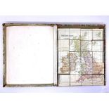
Late-Victorian/Edwardian map block puzzle, comprising 20 wooden cubes with pasted maps on all sides,
Late-Victorian/Edwardian map block puzzle, comprising 20 wooden cubes with pasted maps on all sides, forming alternative jigsaws, London: G. W. Ba...
Collection of five framed & glazed maps and prints, comprising: a 17th-century map of Huntingdonshire, by Joan Blaeu, uncoloured engraving on laid...

Münster, Sebastian. Woodcut map of England, Wales, and parts of Scotland and Ireland, [1540 or
Münster, Sebastian. Woodcut map of England, Wales, and parts of Scotland and Ireland, [1540 or later], on laid paper. The first separately printed...
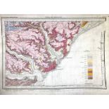
Collection of approximately 40 colour maps from the Geological Survey of Great Britain (England &
Collection of approximately 40 colour maps from the Geological Survey of Great Britain (England & Wales), Southampton: Ordnance Survey, Crown Copy...
Siegfried Atlas. Switzerland. Mountaineering Interest. Cased set of nine maps, Bern: Landestopographie, 1910-1923. Sectional & linen-backed with t...
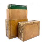
Ordnance Survey. Mudge, William. Cased set of four Ordnance Survey maps in book-box, including
Ordnance Survey. Mudge, William. Cased set of four Ordnance Survey maps in book-box, including Isle of Wight & Part of Hampshire: No. IX, n.d.; No...
Map of the County of Northampton, London: A. Bryant, 1 June 1827. Hand-coloured engraving with inset
Map of the County of Northampton, London: A. Bryant, 1 June 1827. Hand-coloured engraving with inset view of Peterborough Cathedral, on two sheets...
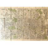
Map of London, engraved for the Post Office Directory, 1906, showing underground railways & tramway routes, sectional, linen-backed, 76cm by 107cm...
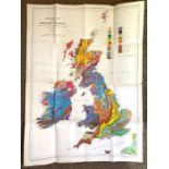
Geological Map of the British Islands, E. B. Bailey, third edition, 1939, Ordnance Survey, Colonel
Geological Map of the British Islands, E. B. Bailey, third edition, 1939, Ordnance Survey, Colonel Duncan A. Johnston, approx. 87cm by 63cm, folde...

London Map. Ellis, J. The London Guide, or A Pocket Plan of the Cities of London & Westminster, &
London Map. Ellis, J. The London Guide, or A Pocket Plan of the Cities of London & Westminster, & Borough & Southwark, with the New Buildings &c. ...