Filtered by:
- Sale Section
- List
- Grid
A subscription to the Price Guide is required to view results for auctions ten days or older. Click here for more information
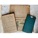

Collection of 19th- & 20th-century OS maps and similar, approximately 50, to include a map of
Collection of 19th- & 20th-century OS maps and similar, approximately 50, to include a map of Birmingham, 1876, with tramways marked and a manuscr...
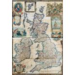
British Isles. Willdey, George. Map of Great Britain and Ireland, 1715. Hand-coloured copper
British Isles. Willdey, George. Map of Great Britain and Ireland, 1715. Hand-coloured copper engraving on laid/chain-lined paper, featuring inset ...
![Moll, Herman. Atlas Minor, London: Thomas & John Bowles, [1736 or later]. Quarto, 58 [of 62] hand-](https://portal-images.azureedge.net/auctions-2021/hanson10391/images/45ed7433-c59c-4ae7-b435-adff00e64338.jpg?w=155&h=155)
Moll, Herman. Atlas Minor, London: Thomas & John Bowles, [1736 or later]. Quarto, 58 [of 62] hand-
Moll, Herman. Atlas Minor, London: Thomas & John Bowles, [1736 or later]. Quarto, 58 [of 62] hand-coloured, copper-engraved maps on laid/chain-lin...
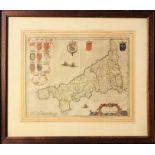
Joan Blaeu (1596-1673). Map of Cornwall, c.1645, hand-coloured copper engraving on laid/chain-
Joan Blaeu (1596-1673). Map of Cornwall, c.1645, hand-coloured copper engraving on laid/chain-lined paper, featuring armorial shields and ships. 4...
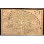
Robert Morden (1650-1703). Map of Norfolk, hand-coloured copper engraving on laid/chain-lined paper,
Robert Morden (1650-1703). Map of Norfolk, hand-coloured copper engraving on laid/chain-lined paper, 38cm by 62cm, framed & glazed. Appears well-p...
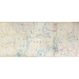
London & Middlesex. Sectional map, linen-backed, hand-coloured outline, Letts & Son, based on
London & Middlesex. Sectional map, linen-backed, hand-coloured outline, Letts & Son, based on Ordnance Survey by Colonel Colby, 12 July 1844. 56" ...
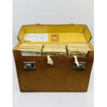
Great Britain. Cased set of 23 sectional, linen-backed road maps, 1933, with RAC route itinerary
Great Britain. Cased set of 23 sectional, linen-backed road maps, 1933, with RAC route itinerary of a journey from Walsall to Dover with street ma...
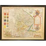
John Speed (1552-1629). Map of Lincolnshire, c.1676, hand-coloured copper engraving on laid/chain-
John Speed (1552-1629). Map of Lincolnshire, c.1676, hand-coloured copper engraving on laid/chain-lined paper, featuring armorial shields, sea mon...
Schenk & Valk. Map of Leicestershire, c.1715, hand-coloured copper engraving on laid/chain-lined
Schenk & Valk. Map of Leicestershire, c.1715, hand-coloured copper engraving on laid/chain-lined paper, featuring armorial shields and figures, 53...
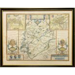
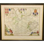
John Speed (1552-1629). Map of Rutland, c.1676, hand-coloured copper engraving on laid/chain-lined
John Speed (1552-1629). Map of Rutland, c.1676, hand-coloured copper engraving on laid/chain-lined paper, featuring inset views of Oakham and Stam...
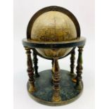
A 16th-century terrestrial globe by, or a derivative of, Francois Demongenet (active 1550-60). 12
A 16th-century terrestrial globe by, or a derivative of, Francois Demongenet (active 1550-60). 12 engraved gores; stippled effect to the seas with...