Refine your search
Sale Section
Remove filter- Library Auction Maps (17)
Estimate
Category
Filtered by:
- Lots with images only,
- Sale Section
- List
- Grid
A subscription to the Price Guide is required to view results for auctions ten days or older. Click here for more information


London Underground. Stingemore, F H. Pocket map of the London Underground, London: Waterlow & Sons
London Underground. Stingemore, F H. Pocket map of the London Underground, London: Waterlow & Sons Limited, June 1927. Printed in colours. 12.6cm ...

London. The Oarsman's and Angler's Map of the River Thames from its Source to London Bridge, London:
London. The Oarsman's and Angler's Map of the River Thames from its Source to London Bridge, London: James Reynolds & Sons, 1891. Folding, hand-co...
![The "District Railway" Map of London, London: Sampson Low, Marston and Company Limited, [c.1898].](https://portal-images.azureedge.net/auctions-2021/hanson10330/images/8b661704-9bef-4230-94db-ad3d01549965.jpg?w=155&h=155)
The "District Railway" Map of London, London: Sampson Low, Marston and Company Limited, [c.1898].
The "District Railway" Map of London, London: Sampson Low, Marston and Company Limited, [c.1898]. Sectional, linen-backed, colour lithographic map...

Map of Canals and Navigable Rivers of England and Wales, by Lionel B. Wells, Manchester & London: G.
Map of Canals and Navigable Rivers of England and Wales, by Lionel B. Wells, Manchester & London: G. Falkner & Sons, [c.1895]. Sectional, linen-ba...
![Hole, William. Map of Scotland, [1610 or later], hand-coloured copper engraving on laid paper, 29.](https://portal-images.azureedge.net/auctions-2021/hanson10330/images/ae304f4a-3c25-4240-be4c-ad3d0154a91b.jpg?w=155&h=155)
Hole, William. Map of Scotland, [1610 or later], hand-coloured copper engraving on laid paper, 29.
Hole, William. Map of Scotland, [1610 or later], hand-coloured copper engraving on laid paper, 29.5cm by 40cm, toned, framed & glazed. Together wi...
![Saxton & Hole. Map of Derbyshire, [c.1637], hand-coloured copper engraving on laid/chain-lined](https://portal-images.azureedge.net/auctions-2021/hanson10330/images/2e1c850d-b289-49c7-b57c-ad3d0154ae61.jpg?w=155&h=155)
Saxton & Hole. Map of Derbyshire, [c.1637], hand-coloured copper engraving on laid/chain-lined
Saxton & Hole. Map of Derbyshire, [c.1637], hand-coloured copper engraving on laid/chain-lined paper, 32cm by 36cm, framed & glazed. Well-preserve...

Speed, John. 17th-century map of British Isles, hand-coloured copper engraving on laid/chain-lined
Speed, John. 17th-century map of British Isles, hand-coloured copper engraving on laid/chain-lined paper featuring heraldic shields and vignettes ...

Speed, John. 17th-century map of Derbyshire, hand-coloured copper engraving on laid/chain-lined
Speed, John. 17th-century map of Derbyshire, hand-coloured copper engraving on laid/chain-lined paper featuring heraldic shields and inset plan of...

Scarce map of London. A New and Accurate Plan of London, Westminster and the Borough of Southwark...to the Year 1782, with a Table of References a...

Staffordshire. Dix, Thomas. A New Map of Stafford, Divided into Hundreds, London: William Darton,
Staffordshire. Dix, Thomas. A New Map of Stafford, Divided into Hundreds, London: William Darton, 6 March 1818. Hand-coloured copper engraving, se...

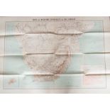
Scarce map showing Catholic Missions in China, 1890. Carte des Missions Catholiques en Chine, by
Scarce map showing Catholic Missions in China, 1890. Carte des Missions Catholiques en Chine, by Adrien Launay, Paris: R.Hausermann, Lemercier & C...
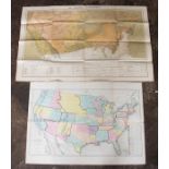
Scarce map showing Catholic Missions in United States, 1877. Les Missions Catholiques, Paris:
Scarce map showing Catholic Missions in United States, 1877. Les Missions Catholiques, Paris: Dufrenoy, L. Wuhrer, 1877. Hand-coloured lithograph,...
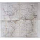
Three maps showing Catholic Missions in Africa, Missions Catholiques: Carte Ecclesiastique de l'
Three maps showing Catholic Missions in Africa, Missions Catholiques: Carte Ecclesiastique de l'Afrique, by R. P. Meillorat, Paris: Lemercier, Hau...
Three maps showing Catholic Missions: Carte Ecclesiastique de l'Empire Ottoman, Paris: Lemercier,
Three maps showing Catholic Missions: Carte Ecclesiastique de l'Empire Ottoman, Paris: Lemercier, Hausermann, 1893, 78.5cm by 99.5cm; Carte des Mi...

Collection of maps, to include A Map of England and Wales for the Complete History of England, by T.
Collection of maps, to include A Map of England and Wales for the Complete History of England, by T. Kitchin, n.d., 49cm by 41cm, linen-backed, cr...
![Blome, Richard. Map of Worcestershire, [1673], hand-coloured copper engraving on laid/chain-lined](https://portal-images.azureedge.net/auctions-2021/hanson10330/images/93c51b94-6d35-4063-b849-ad3d0154f495.jpg?w=155&h=155)
Blome, Richard. Map of Worcestershire, [1673], hand-coloured copper engraving on laid/chain-lined
Blome, Richard. Map of Worcestershire, [1673], hand-coloured copper engraving on laid/chain-lined paper, 29cm by 34.5cm, maple veneer frame, glaze...
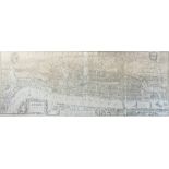
Agas, Ralph (after). 19th-century map, 'London in the reign of Queen Elizabeth', panoramic view/
Agas, Ralph (after). 19th-century map, 'London in the reign of Queen Elizabeth', panoramic view/plan, London: Cassell, Peter & Galpin, 48cm by 125...