Filtered by:
- Category,
- Item Type
- List
- Grid
A subscription to the Price Guide is required to view results for auctions ten days or older. Click here for more information
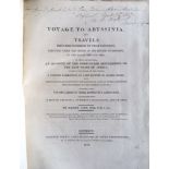

Salt, Henry. A Voyage to Abyssinia, first edition, London: F. C. and J. Rivington, 1814. 36 [of
Salt, Henry. A Voyage to Abyssinia, first edition, London: F. C. and J. Rivington, 1814. 36 [of 37] plates/maps/vignettes, including five folding ...
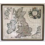
Carel Allard (1648-1709), late-17th century map of British Isles, hand-coloured copper engraving
Carel Allard (1648-1709), late-17th century map of British Isles, hand-coloured copper engraving on laid/chain-lined paper, framed & glazed, Boyde...
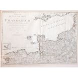
Three large late-18th century maps of Channel Islands, Isle of Man and Scilly Isles (the Channel
Three large late-18th century maps of Channel Islands, Isle of Man and Scilly Isles (the Channel Islands map dated 1790, "Frankreich" by Engelman)...
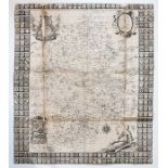
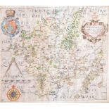
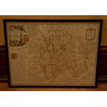
Robert Plot map of Staffordshire, 17th Century, copper engraving on laid paper, linen backed,
Robert Plot map of Staffordshire, 17th Century, copper engraving on laid paper, linen backed, folded, some wear on fold lines, 63 by 53cm, unframe...
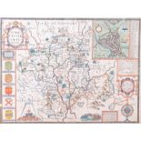
Speed, John (1552-1629). 17th-century map of Staffordshire, hand-coloured copper engraving on laid/
Speed, John (1552-1629). 17th-century map of Staffordshire, hand-coloured copper engraving on laid/chain-lined paper, featuring inset views of Lic...
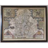
Speed, John (1552-1629). 17th-century map of Worcestershire, hand-coloured copper engraving on
Speed, John (1552-1629). 17th-century map of Worcestershire, hand-coloured copper engraving on laid/chain-lined paper, featuring inset view of Wor...
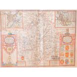
Speed, John (1552-1629). 17th-century map of Warwickshire, hand-coloured copper engraving on laid/
Speed, John (1552-1629). 17th-century map of Warwickshire, hand-coloured copper engraving on laid/chain-lined paper, featuring inset views of Cove...
Saxton & Hole 17th-century map of Worcestershire, hand-coloured copper engraving on laid/chain-lined
Saxton & Hole 17th-century map of Worcestershire, hand-coloured copper engraving on laid/chain-lined paper, framed & glazed, 30cm by 33cm. Togethe...
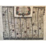
Collection of four framed antique maps, comprising: John Ogilby road map, London to Shrewsbury,
Collection of four framed antique maps, comprising: John Ogilby road map, London to Shrewsbury, hand-coloured copper engraving on laid/chain-lined...
18th-century map of Worcestershire, by Emanuel Bowen, hand-coloured copper engraving on laid/chain-
18th-century map of Worcestershire, by Emanuel Bowen, hand-coloured copper engraving on laid/chain-lined paper, published in London by R. Sayer & ...