Filtered by:
- Show only bulk lots,
- Sale Section
- List
- Grid
A subscription to the Price Guide is required to view results for auctions ten days or older. Click here for more information

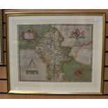
Richard Blome 17th-century map of Rutland, hand-coloured copper engraving on laid/chain-lined paper.
Richard Blome 17th-century map of Rutland, hand-coloured copper engraving on laid/chain-lined paper. Together with an 18th century engraved prospe...
Saxton, Christopher (1540-1610).
Saxton, Christopher (1540-1610). 16th-century map of Staffordshire, hand-coloured copper engraving on laid/chain-lined paper. Framed & glazed. 39....

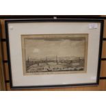
A Plan of the Grand Canal from the Trent to the Mersey, July 1771, hand-coloured copper engraving,
A Plan of the Grand Canal from the Trent to the Mersey, July 1771, hand-coloured copper engraving, 20cm by 38cm, framed

19th-century manuscript map of England & Wales by Master J. Fisher, the title and scale border is engraved (printed) but the map itself is ink & w...
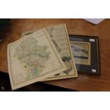
Collection of five 18th & 19th Century copper-engraved hand-coloured maps of Staffordshire (including Emanuel Bowen, Teesdale, J. Ellis) together ...
![Anonymous [William Smith] 17th-century map of Staffordshire,](https://portal-images.azureedge.net/auctions-2018/hanson10164/images/55006fb5-5ee9-42f2-b03d-a9970117c00d.jpg?w=155&h=155)
Anonymous [William Smith] 17th-century map of Staffordshire, hand-coloured copper engraving on laid/chain-lined paper, scarce, Stent & Overton, c....
An 1870s map of Spain & Portugal, linen-backed, original Stanford buckram case. Together with an Edwardian map of England & Wales, colour lithogra...
Speed, John (1552-1629).
Speed, John (1552-1629). 17th-century map of The North & East Riding of Yorkshire, copper engraving on laid/chain-lined paper bearing manufacturer...
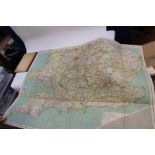
A collection of maps,
A collection of maps, vintage UK maps etc (one bag)