Filtered by:
- Sale Section
- List
- Grid
A subscription to the Price Guide is required to view results for auctions ten days or older. Click here for more information


Sea chart / map of Ireland, 'Achill Head to Slyne Head', featuring a table of tidal information,
Sea chart / map of Ireland, 'Achill Head to Slyne Head', featuring a table of tidal information, originally published at the Admiralty, 19th Decem...
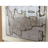
Morden, Robert (c.1650-1703).
Morden, Robert (c.1650-1703). Collection of three antique maps: two examples of 'Britannia Saxonica' (variations in colouring), and England & Wale...

A collection of three framed, Thomas Moule 19th Century maps, hand tinted, steel engraved, Derbyshire, Rutland and Cumberland, together with a 192...

Collection of nine framed engraved maps, late 18th and 19th Century, including examples by J.
Collection of nine framed engraved maps, late 18th and 19th Century, including examples by J. Cary (9)

Derby Interest and Natural History folder of maps and pictures

'Cary's New Map of England and Wales', London J. Cary 1794, numerous plates, disbound, not collated a/f, together with further loose plates/maps b...


A box of Ordenance Survey maps etc, some hessian backed, including some miniature