Filtered by:
- Category,
- Creator / Brand
2 items
- List
- Grid
This auctioneer has chosen to not publish their results. Please contact them directly for any enquiries.
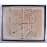

Lot 446
A 17TH CENTURY CHARLES II MAP OF THE WEST ROAD C1676 London to Bristol. Image 49 cm x 38 cm.
A 17TH CENTURY CHARLES II MAP OF THE WEST ROAD C1676 London to Bristol. Image 49 cm x 38 cm.
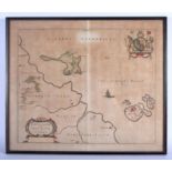
Lot 448
A 17TH CENTURY CONTINENTAL MAP OF THE HOLY ISLAND by J Blaeu C1646, Farne, Northumberland. Image 54
A 17TH CENTURY CONTINENTAL MAP OF THE HOLY ISLAND by J Blaeu C1646, Farne, Northumberland. Image 54 cm x 54 cm.