Refine your search
Filtered by:
- Sale Section,
- Category,
- Item Type
- List
- Grid
A subscription to the Price Guide is required to view results for auctions ten days or older. Click here for more information
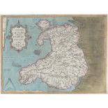

Llwyd (Humphrey) Map of Wales, 1574, text on reverse, engraving, 37.5 x 50cm
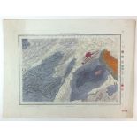
Colby (Lt-Col) RE A collection of five geological survey maps of Shropshire and suronding areas,
Colby (Lt-Col) REA collection of five geological survey maps of Shropshire and suronding areas, published at the ordance map office, Tower of Lond...
Cary (John)A New Map of the Principality of Wales Divided into Counties, 1811, engraving, unframed, 54 x 63.5cm (2)
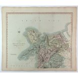
Morden (Robert) A New and Correct map of North Wales, engraving, unframed,37 x 44cm (PL)
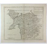
C and I Greenwood Map of the County of Middlesex from an actual survey made in the years 1819 and
C and I Greenwood Map of the County of Middlesex from an actual survey made in the years 1819 and 1820, engraving, unframed, 57 x 71cm (SH)
Dix (T) after Darton (W) A New Map of North Wales Divided into Six Counties or Shires, engraving,
Dix (T) after Darton (W) A New Map of North Wales Divided into Six Counties or Shires, engraving, unframed, 58 x 81cm (SH)
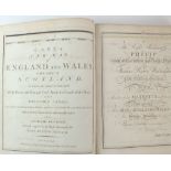
Cary (John)Cary's New Map of England and Wales with Part of Scotland 1794, a bound volume of 77maps covering Engalnd and Wales.
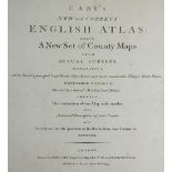
Cary (John) Cary's New and Correct English Atlas being a New Set of County Maps from Actual Surveys
Cary (John)Cary's New and Correct English Atlas being a New Set of County Maps from Actual Surveys 1793, Forty six county maps each with a descrip...