Filtered by:
- Category,
- Item Type
- List
- Grid
A subscription to the Price Guide is required to view results for auctions ten days or older. Click here for more information
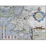

Speed (John) Map of Pembrokeshire, published by John Sudbury and George Humbell, 1610, engraving,
Speed (John) Map of Pembrokeshire, published by John Sudbury and George Humbell, 1610, engraving, text verso, 39 x 51cm (I)
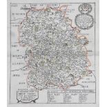
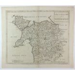
Speed (John) Map of Montgomeryshire, published by John Sudbury and George Humbell 1610, engraving, text verso, 39 x 52cm (PL)
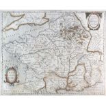
Jansson (Jan)Map of France 1657, engraving, text on verso, 40 x 49.5cm (PL) together with a Map of North East France by Dankerts (2)
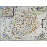
Speed (John) Map of Anglesey, published by John Sudbury and George Humbell in 1612, engraving,
Speed (John) Map of Anglesey, published by John Sudbury and George Humbell in 1612, engraving, with text verso, 38.5 x 50.5cm (I)
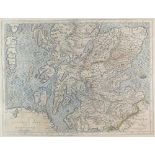
Hole (William) Scotia Regnum 1610, engraving, 27 x 31cm (PL)together with a late 16th century map of 'Scotia' after Gerard Mercator (2)
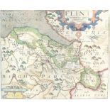
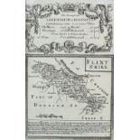
Saxton (Christopher) and Kip (William) Flint Comitatus, engraving, text verso, 26.5 x 32cm (PL)together with a map 'Caernarvo Comitatus' by Saxton...
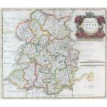
Morden (Robert) Map of Shrophsire, 17th century, engraving, unframed, 37 x 42.5cm (PL)
A collection of four English 17th century maps: The road from London to Aberistwith and Welshpool
A collection of four English 17th century maps: The road from London to Aberistwith and Welshpool to Carnarvan by Owen Bowen, together with two fu...
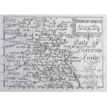
Blome (Richard) A General Mapp of Shropshire, 1673, engraving, 32 x 27cm (PL) together with another 17th century map of Shropshire by Richard Blom...
Rocque (John) Map of Shropshire, a plate from the Small British Atlas, 1753, reissued 1769, engraving, 20 x 16.5cm (SH)together with two maps of S...
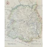
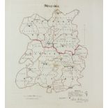
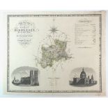
Greenwood and Co Map of the County of Salop from an actual survey made in the years 1826 and 1827,
Greenwood and Co Map of the County of Salop from an actual survey made in the years 1826 and 1827, published by Greenwood and co, London, Feb 24th...
A collection of unframed engraved maps of Shropshire: H.Moll, Shropshire 1724, T.Hutchison, A Correct Map of Shropshire 1748, J.Cary, Shropshire 1...
Dawson (Lt.R.
Dawson (Lt.R.K)A collection of four maps of Oswestry, Shropshire, Bridgnorth and Shrewsbury, unframed, various sizes, and a map of Ludlow after R....
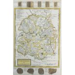
Bill (J) Shropshire, 1626,
Bill (J)Shropshire, 1626, a rare map from an atlas printed only once and the earliest map of the county to show latitude and longitude, engraving,...
Bowen and Owen Shrewsbury to Holwell, small road strip map with Flintshire on the reverse, engraving, unframed, 19.5 x 13cm (SH), together with a ...
A Collection of unframed engraved Shropshire maps: Shropshire 1803/6 by J Luffman, Shropshire 1808 by G.Cole, Sjropshire 1816 by G.Cole, langley's...
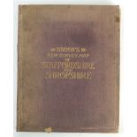
Bacon's New Survey Map of Staffordshire and Shropshire, laid on linen, 114 x 90cm (SH)
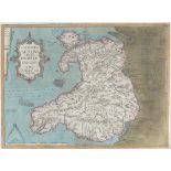
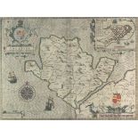
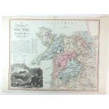
Llwyd (Humphrey) Map of Wales, 1574, text on reverse, engraving, 37.5 x 50cm
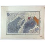
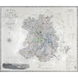
Colby (Lt-Col) RE A collection of five geological survey maps of Shropshire and suronding areas,
Colby (Lt-Col) REA collection of five geological survey maps of Shropshire and suronding areas, published at the ordance map office, Tower of Lond...
Cary (John)A New Map of the Principality of Wales Divided into Counties, 1811, engraving, unframed, 54 x 63.5cm (2)
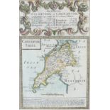
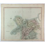
Morden (Robert) A New and Correct map of North Wales, engraving, unframed,37 x 44cm (PL)
C and I Greenwood Map of the County of Middlesex from an actual survey made in the years 1819 and
C and I Greenwood Map of the County of Middlesex from an actual survey made in the years 1819 and 1820, engraving, unframed, 57 x 71cm (SH)
Dix (T) after Darton (W) A New Map of North Wales Divided into Six Counties or Shires, engraving,
Dix (T) after Darton (W) A New Map of North Wales Divided into Six Counties or Shires, engraving, unframed, 58 x 81cm (SH)
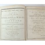
Cary (John)Cary's New Map of England and Wales with Part of Scotland 1794, a bound volume of 77maps covering Engalnd and Wales.
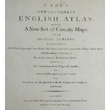
Cary (John) Cary's New and Correct English Atlas being a New Set of County Maps from Actual Surveys
Cary (John)Cary's New and Correct English Atlas being a New Set of County Maps from Actual Surveys 1793, Forty six county maps each with a descrip...