Refine your search
Filtered by:
- Sale Section,
- Item Type
- List
- Grid
A subscription to the Price Guide is required to view results for auctions ten days or older. Click here for more information
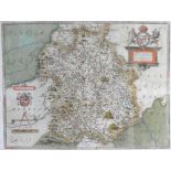

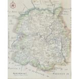
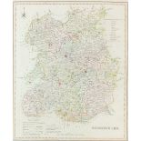
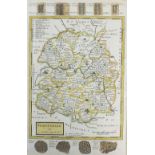
Saxton (Christopher) Salopiae Comitatus, One of thirty five maps of An Atlas of England and Wales,
Saxton (Christopher) Salopiae Comitatus, One of thirty five maps of An Atlas of England and Wales, first edition (Christopher Saxton, 1579), engra...
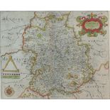
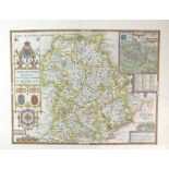
Speed (John) Map of Shropshire, 1676, Engraving, English text verso, 39 x 51cm (PL)
Hole (William) after Saxton (Christopher), early 17th century, Map of Shropshire, engraving,
Hole (William) after Saxton (Christopher), early 17th century, Map of Shropshire, engraving, 27 x 33cm (PL)
Blome (Richard) A General Mapp of Shropshire, 1673, engraving, 32 x 27cm (PL) together with another 17th century map of Shropshire by Richard Blom...
Rocque (John) Map of Shropshire, a plate from the Small British Atlas, 1753, reissued 1769, engraving, 20 x 16.5cm (SH)together with two maps of S...
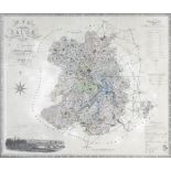
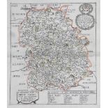
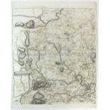
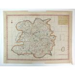
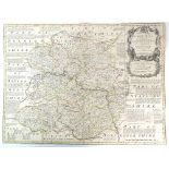
Greenwood and Co Map of the County of Salop from an actual survey made in the years 1826 and 1827,
Greenwood and Co Map of the County of Salop from an actual survey made in the years 1826 and 1827, published by Greenwood and co, London, Feb 24th...
Hole (William) Salopie 1610, Engraving, 27.5 x 34cm, together with 'A General Mapp of Shropshire' by Richard Blome, engraving, both unframed (2)
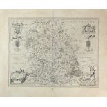
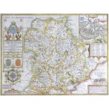
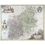
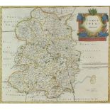
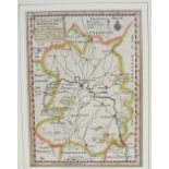
Blaeu (J) Comitatus Salopiensis Anglice Shropshire 1645, text from Camdens Britannia on reverse,
Blaeu (J)Comitatus Salopiensis Anglice Shropshire 1645, text from Camdens Britannia on reverse, engraving, unframed, 38.5 x 50cm (PL)
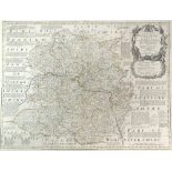
Jansson J/ Schenk and Valk Salopiensis Comitatus cum Staffordiensi, engraving, unframed, 41.
Jansson J/ Schenk and ValkSalopiensis Comitatus cum Staffordiensi, engraving, unframed, 41.5 x 51cm (PL)
Bowen (Emmanuel) An accurate map of Shropshire divided into hundreds, circa 1765, reprint of first edition of 'Large English Atlas' 1751, engravin...
Bowen (Thomas) London to Shrewsbury and Welshpool in Montgomery, road map, published in the Gentleman's Magazine 1765-1775, engraving, unframed, 1...
Cary (John) A map of Shropshire from the West Authorities, 1805, engraving, unframed, 50 x 43cm (PL)together with 'A New Map of Shropshire, Divide...
Rowe (R) Shropshire, engraving, 46 x 36cm (SH) together with a map of Shropshire bu S.Hall, a plan of the Ellesmere Canal by I Muslow, a map of Sh...
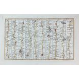
Rocque (John) Map of Salop, printed in 4 sheets, 1752, inscribed: 'To his Royal Highness George Prince of Wales & c. This Actual Survey of the Cou...
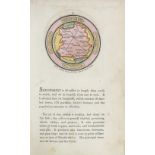
Drayton (Michael) The Parte of Shropshyre on the West of the Severne (song 8) and Parte of Shropshyre on the East of the Severne (song 12), 1612, ...
Morden (Robert) Map of Shropshire, 1722, engraving, unframed, 39.5 x 45cm (PL), together with an unframed 1708 map of Shropshire by Robert Morden ...
A collection of unframed engraved maps of Shropshire: H.Moll, Shropshire 1724, T.Hutchison, A Correct Map of Shropshire 1748, J.Cary, Shropshire 1...
Haywood A Map of Shropshire Engraved From an Actual Survey with Improvements, 1788/92, engraving,
HaywoodA Map of Shropshire Engraved From an Actual Survey with Improvements, 1788/92, engraving, unframed, 34 x 48cm (PL)together with 'A Map of t...
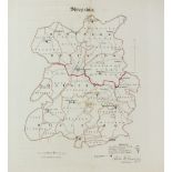
Dawson (Lt.R.
Dawson (Lt.R.K)A collection of four maps of Oswestry, Shropshire, Bridgnorth and Shrewsbury, unframed, various sizes, and a map of Ludlow after R....
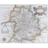
Bill (J) Shropshire, 1626,
Bill (J)Shropshire, 1626, a rare map from an atlas printed only once and the earliest map of the county to show latitude and longitude, engraving,...
Seller (John)Map of Shropshire 1695, engraving, unframed, 12.5 x 15cm (PL), together with another unframed map of Shropshire 1695/1703 by John Sel...
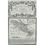
Bowen and Owen Shrewsbury to Holwell, small road strip map with Flintshire on the reverse, engraving, unframed, 19.5 x 13cm (SH), together with a ...
A Collection of unframed engraved Shropshire maps: Shropshire 1803/6 by J Luffman, Shropshire 1808 by G.Cole, Sjropshire 1816 by G.Cole, langley's...
Bowen (Eman) An Accurate Map of Shropshire Divided into its Hundreds 1760, engraving laid in linen,
Bowen (Eman) An Accurate Map of Shropshire Divided into its Hundreds 1760, engraving laid in linen, unframed in slip case, 54 x 72cm (SH)
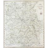
Baugh (Robert) Map of Shropshire 1808, with an engraved view and dedication to 'The Right Honourable Edward Earl of Powys, Lord Lieutenant and Cus...
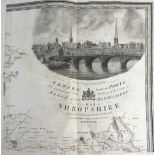
Overton (Henry) after Speed (John) Shropshire Described The Situation of Shrowsbury Shewed with
Overton (Henry) after Speed (John) Shropshire Described The Situation of Shrowsbury Shewed with the Armes of thos Earles, and other Memorable thin...
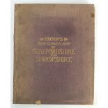
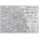
Bacon's New Survey Map of Staffordshire and Shropshire, laid on linen, 114 x 90cm (SH)