Refine your search
Filtered by:
- Category,
- Creator / Brand
- List
- Grid
A subscription to the Price Guide is required to view results for auctions ten days or older. Click here for more information
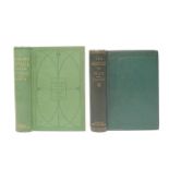

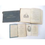
Charles Darwin, two titles: 'The Descent of Man, and Selection in Relation to Sex', London, Murray,
Charles Darwin, two titles: 'The Descent of Man, and Selection in Relation to Sex', London, Murray, 1882, 2nd edition revised and augmented, 15th ...
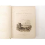
James Stark & John Warden Robberds: 'Scenery of the Rivers of Norfolk, Comprising The Yare,
James Stark & John Warden Robberds: 'Scenery of the Rivers of Norfolk, Comprising The Yare, The Waveney and The Bure', Norwich and London, John St...
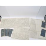
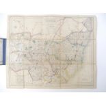
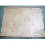
Ordnance Survey map of Norfolk, circa 1836-1838, eight separate engraved folding map sheets,
Ordnance Survey map of Norfolk, circa 1836-1838, eight separate engraved folding map sheets, each dissected and backed onto linen, each scale one ...
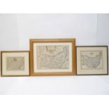
William Kip after Christopher Saxton: 'Suffolciae Comitatus', hand coloured engraved map of Suffolk,
William Kip after Christopher Saxton: 'Suffolciae Comitatus', hand coloured engraved map of Suffolk, circa 1610, framed and glazed, together with ...
J & C Walker: 'Suffolk', engraved folding hand coloured map, published London, Longman, Rees & Co,
J & C Walker: 'Suffolk', engraved folding hand coloured map, published London, Longman, Rees & Co, circa 1881, approx 32 x 39cm, backed onto linen...
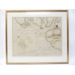
Capt. Greenville Collins: 'Harwich Woodbridge and Handfordwater with the Sands from the Nazeland to
Capt. Greenville Collins: 'Harwich Woodbridge and Handfordwater with the Sands from the Nazeland to Hosely Bay, Yarmouth and the Sands about it', ...
A circa 1720 engraved map/print showing views of the East coast of England and Scotland, from Dunwich & Walberswick through to Aberdeen, including...
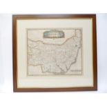
Robert Morden: 'Suffolk', engraved hand coloured map, circa 1695, approx 36 x 42cm, framed and glazed, the whole approx. 60cm x 64cm
Thomas Martin, of Palgrave, Suffolk: 'The History of the Town of Thetford', London, 1779, portrait frontis + 9 plates as called for (but plate I '...
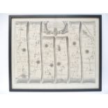
John Ogilby: 'The Road from King's Lynn to Norwich, Continued to Yarmouth in Norfolk', engraved road strip map, circa 1675, framed and glazed, who...
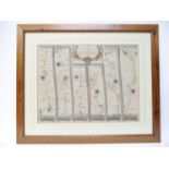
John Ogilby: 'The Road from London to Yarmouth', engraved hand coloured road strip map, approx.
John Ogilby: 'The Road from London to Yarmouth', engraved hand coloured road strip map, approx. 33 x 44cm, framed and glazed, whole approx 53cm x ...
![John Ogilby: 'The Road from Welshpool Com Montgomery to Carnarvon [Caernarfon] in North Wales',](https://portal-images.azureedge.net/auctions-2021/srtw10293/images/162e1da6-0169-4661-9f03-ada6010d85e8.jpg?w=155&h=155)
John Ogilby: 'The Road from Welshpool Com Montgomery to Carnarvon [Caernarfon] in North Wales',
John Ogilby: 'The Road from Welshpool Com Montgomery to Carnarvon [Caernarfon] in North Wales', engraved hand coloured road strip map, circa 1695,...
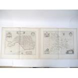
Johannes Blaeu, Glamorganshire & Brecknockshire, two engraved county maps, circa 1648, French text verso, each approx. 38.5 x 51cm, good margins, ...
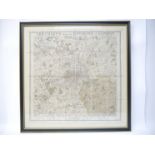
G.F. Cruchley: 'Cruchley's Improved Environs of London', engraved hand coloured sectional map
G.F. Cruchley: 'Cruchley's Improved Environs of London', engraved hand coloured sectional map, backed onto linen, circa 1830, map of London showin...
John Rocque: 'An exact survey of the city's of London, Westminster, ye borough of Southwark...
John Rocque: 'An exact survey of the city's of London, Westminster, ye borough of Southwark...', 1741, but later edition published Edward Stanford...
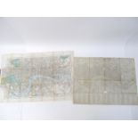
John Cary: 'London, Westminster & Southwark', engraved folding map, dissected and backed onto linen, 1787, a/f, some part losses/wear, approx siz...
John Betts: 'New Itinerant & Commercial Map of England & Wales on which the various Lines of
John Betts: 'New Itinerant & Commercial Map of England & Wales on which the various Lines of Railroad, the Turnpike & Principal Cross Roads, with ...
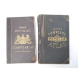
Letts, Son & Co: 'Letts's Popular Atlas', 1884, "complete edition", 154 (of 156) double page maps (lacks no 37 & 44), gutta percha perished, leave...
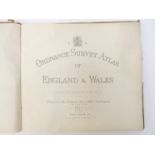
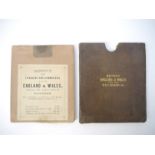
'Ordnance Survey Atlas of England & Wales', O.S. Office for Edward Stanford Ltd., 1922, 24 linen backed double page coloured maps as called for, l...

Tomas Lopez: 'Mapa de España y Portugal Al Ex. S. Marques de la Romana Vincente Beneyto Valencia del Cid. 1809', engraved hand coloured folding ma...
John Arrowsmith: 'An Atlas of Ancient Geography Compiled From original Authorities for the Use of
John Arrowsmith: 'An Atlas of Ancient Geography Compiled From original Authorities for the Use of Schools', London, J. Arrowsmith, 1844, 26 double...