Filtered by:
- Category
- List
- Grid
A subscription to the Price Guide is required to view results for auctions ten days or older. Click here for more information
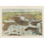

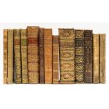
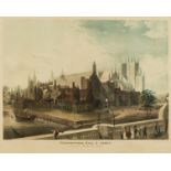
America.- Illustrated London News (The) Bird's-Eye View of Boston, United States, wood-engraving after T. Sulman, with full hand-colouring, image ...
Africa.- Livingstone (David) Missionary Travels and Researches in South Africa, first edition, 1857.
NO RESERVE Africa.- Livingstone (David) Missionary Travels and Researches in South Africa, first edition, folding wood engraved frontispiece and 2...
China.- Alexander (William) and Sir George Staunton. Three plates from 'An Authentic Account of An …
China.- Alexander (William) and Sir George Staunton. Three plates, from: 'An Authentic Account of An Embassy from the King of Great Britain to the...
Crimea.- Lièvre (Édouard) Retour de Crimée, Paris, c.1850; and another on the Crimean War (3)
Crimea.- Lièvre (Édouard) Retour de Crimée, hand-coloured lithograph title and 15 hand-coloured lithograph plates, scattered spotting, faint margi...
Europe.- Ireland (Samuel) A Picturesque Tour through Holland, Brabant, and part of France, 2 vol., …
Europe.- Ireland (Samuel) A Picturesque Tour through Holland, Brabant, and part of France, 2 vol., second edition, aquatint vignette titles, 46 aq...
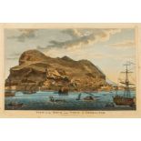
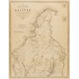
Gibraltar.- Laurie (Richard Holmes, publisher) View of the Rock and Town of Gibraltar, engraving with hand-colouring, numbered '28' in the upper r...
India.- Collection of 10 aquatint plates with hand-colouring on scenes in India, [early 19th …
India.- A Collection of 10 plates of scenes in India, ?from Giulio Ferrario's 'Il Costume Antico e Moderno... l'America', aquatint with hand-colou...

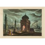
Italy.- Reinhardt (Johann Christian) In Villa Mecenate a Tivoli, etching, an excellent impression on laid paper with watermark of two concentric c...
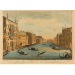
Italy.- Vues d'optique.- Six views of Venice and Florence, after Canaletto and Zocchi, engravings with hand-colouring, on various wove and laid pa...
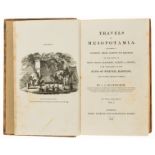
Middle East.- Buckingham (James Silk) Travels in Mesopotamia, 2 vol., 27 wood engraved plates, 2 double-page lithographs, double-page folding map,...
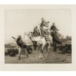
Middle East.- Vernet (Emile-Jean-Horace, 1789-1863), After. Voyage au Désert, mixed-method engraving and etching, by Rollet, a good impression on ...
Polar.- Antarctic.- Snow (W. Parker) A Two Years' Cruise off Tierra del Fuego, the Falkland …
Polar.- Antarctic.- Snow (W. Parker) A Two Years' Cruise off Tierra del Fuego, the Falkland Islands, Patagonia and in the River Plate, 2 vol., fir...
East Anglia.- Badeslade (Thomas) The History of the Ancient and Present State of the Navigation of …
East Anglia.- Badeslade (Thomas) The History of the Ancient and Present State of the Navigation of the Port of King's-Lyn, and of Cambridge ..., f...
London.- Ackermann (Rudolph) Eight views from the series 'Views of London, from a series that included 18 views in total produced over a decade, i...
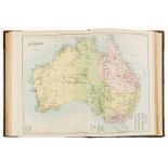
Atlases.- Black (Adam and Charles) Black's General Atlas of The World, New and Revised Edition, …
Atlases.- Black (Adam and Charles) Black's General Atlas of The World, New and Revised Edition, frontispiece with flags of nations, title, and com...
Atlases.- Pinkerton (John) 22 double-page sheets from 'A Modern Atlas, from the latest and best …
NO RESERVE Atlases.- Pinkerton (John) 22 double-page sheets from 'A Modern Atlas, from the latest and best authorities', including Arabia, 'Spanis...
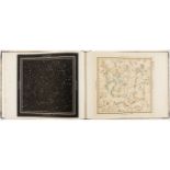
Celestial Atlas.- Middleton (James) A Celestial Atlas containing Maps of all the Constellations …
Celestial Atlas.- Middleton (James) A Celestial Atlas containing Maps of all the Constellations visible in Great Britain..., calligraphic title, f...
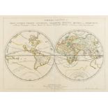
World.- Sanson (Nicolas) and Pierre Mariette. Orbis Vetus, et Orbis Veteris Utraque Continens, …
World.- Sanson (Nicolas) and Pierre Mariette. Orbis Vetus, et Orbis Veteris Utraque Continens, Terrarumque Tractus Arcticus, et Antarcticus ex Pla...
![World.- Morden (Robert) A New Map of ye World, [c.1680].](https://portal-images.azureedge.net/auctions-2021/forum-10286/images/1feeaca0-2338-4723-8fee-adb700c6e684.jpg?w=155&h=155)
World.- Morden (Robert) A New Map of ye World, double-hemisphere world map, engraving with hand-colouring on laid paper without watermark, platema...

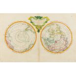
World.- Moll (Herman) A New Map of the Whole World with the Trade Winds According to ye Latest and …
World.- Moll (Herman) A New Map of the Whole World with the Trade Winds According to ye Latest and Most Exact Observations, double-hemisphere worl...
![World.- Jefferys (Thomas) The World, agreable to the latest discoveries, [c.1760].](https://portal-images.azureedge.net/auctions-2021/forum-10286/images/c28d05fe-66da-4dca-a620-adb700c6c328.jpg?w=155&h=155)
World.- Jefferys (Thomas) The World, agreable to the latest discoveries, double-hemisphere world map with vignette illustrations to each segment, ...
World.- Polar.- Moithey (Maurille Antoine) Le Globe Terrestre Vu en Convexe par les Deux Poles, …
World.- Polar.- Moithey (Maurille Antoine) Le Globe Terrestre Vu en Convexe par les Deux Poles, l'Equateur Servant d'Horison, two hemispheres on C...
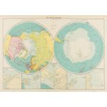
Polar.- Collection of 32 maps of the polar regions, engravings and lithographs, mainly 19th …
Polar.- Collection of 32 maps of the polar regions, including maps by or published by Johnston, George Philip & Son, Edward Weller, S.D.U.K., J. &...
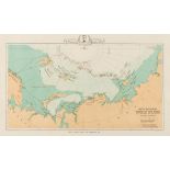
Polar.- Royal Geographical Society.- Sketch Map Showing Route of the 'Fram' and Nansen's and …
Polar.- Royal Geographical Society.- Sketch Map Showing Route of the 'Fram' and Nansen's and Johansen's Sledge Journey, leaflet map printed for th...
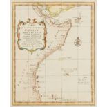
NO RESERVE Africa.- Collection of 45 maps of Africa, including maps by Jacques Nicolas Bellin, Fullarton, Blackwood & Sons, Edward Weller, and oth...
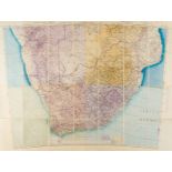
Africa.- War Office (Geographical Section) South West Africa. Transvaal. Third Edition. Army/Air …
Africa.- War Office (Geographical Section) South West Africa. Transvaal. Third Edition. Army/Air Style, map extending from Cape Town to Rhodesia, ...

Americas.- Homann (Johann Baptist) Totius Americae Septentrionalis et Meridionalis Novissima …
Americas.- Homann (Johann Baptist) Totius Americae Septentrionalis et Meridionalis Novissima Repraesentatio quam ex Singulis Recentium Geographoru...
![Americas.- Gilbert (James) Mexico & Texas, [c. 1845].](https://portal-images.azureedge.net/auctions-2021/forum-10286/images/bf433285-7f10-4d8f-a58c-adb700c7a0be.jpg?w=155&h=155)
*** Please note, the description of this lot has changed.Americas.- Gilbert (James) Mexico & Texas, Mexico and the southwest of present United Sta...
![Americas .- Wyld (James) Republic of Mexico, [c. 1845].](https://portal-images.azureedge.net/auctions-2021/forum-10286/images/ede7c6ba-368b-406b-9324-adb700c803e7.jpg?w=155&h=155)
Americas .- Wyld (James) Republic of Mexico, a close variant to Wyld's 'Republic of Mexico and Texas', showing Texas as separate from the United S...
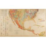
America.- Stone (George W.) Geologic Map of North America, 1946; and two others similar, 1949-1952 …
America.- Stone (George W.) Geologic Map of North America, lithograph printed in colours, 980 x 1380 mm (38 1/2 x 54 1/4 in), minor nicks and tear...
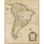
South America.- Seale (Richard William) A Map of South America with All the European Settlements & …
South America.- Seale (Richard William) A Map of South America with All the European Settlements & Whatever Else Is Remarkable from the Latest & B...

South America.- Collection of nine maps of South American countries and regions, 18th and 19th …
South America.- Collection of nine maps of South American countries, including four maps of Peru and Ecuador by Bellin, focussing on Lima and Uppe...
South America.- Columbia.- Paz (Manuel Maria) Four maps from 'Atlas geográfico e histórico de la …
South America.- Columbia.- Paz (Manuel Maria) Four maps from 'Atlas geográfico e histórico de la República de Colombia', including 'Carta Corograf...
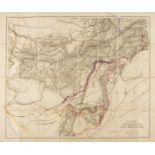
Central Asia.- Stanford (Edward) Stanford's Large Scale Map of Afghanistan showing the Present …
Central Asia.- Stanford (Edward) Stanford's Large Scale Map of Afghanistan showing the Present British Frontiers, lithograph with some hand-colour...
![Asia.- National Geograpic (Soc.) Southwest Asia, India, Pakistan, And Northeast Africa, [c. 1952]; …](https://portal-images.azureedge.net/auctions-2021/forum-10286/images/18378631-597c-4381-aa41-adb700c83edf.jpg?w=155&h=155)
Asia.- National Geograpic (Soc.) Southwest Asia, India, Pakistan, And Northeast Africa, [c. 1952]; …
Asia.- National Geographic (Soc.) Southwest Asia, India, Pakistan, And Northeast Africa, large map of Asia and the Middle-East, lithograph printed...
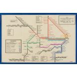
Australia.- Harry Beck London Underground variant.- Commissioner for Railways (New South Wales) …
Australia.- Harry Beck London Underground variant.- Commissioner for Railways (New South Wales) Railway Map, Sydney Suburban and City Underground ...
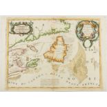
Canada.- Coronelli (Vincenzo Maria) Canada Orientale nell' America Settentrionale Descritta..., …
Canada.- Coronelli (Vincenzo Maria) Canada Orientale nell' America Settentrionale Descritta..., focused on Newfoundland and the mouth of the St. L...
![Central Europe.- Lotter (Tobias Conrad) Tabula Hungaria, [c. 1760]; together with 'Mappa …](https://portal-images.azureedge.net/auctions-2021/forum-10286/images/bd8f8b65-fc9b-43a4-8672-adb700c7d5ef.jpg?w=155&h=155)
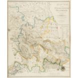
Central Europe.- Lotter (Tobias Conrad) Tabula Hungaria, engraving with original hand-colouring, platemark 470 x 650 mm (18 1/2 x 25 1/2 in), wide...
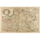
Central & Eastern Europe.- Mortier (Pierre) Estats De Pologne Subdivises suivant l'estendue des …
Central & Eastern Europe.- Mortier (Pierre) Estats De Pologne Subdivises suivant l'estendue des Palatinats Parle Sr. Sanson, large map of Poland, ...
![China and Japan.- Covens & Mortier (Publishers) Imperii Sinarum Nova Descriptio, [circa 1695].](https://portal-images.azureedge.net/auctions-2021/forum-10286/images/347357d4-9adb-45ae-8d30-adb700c7c6cd.jpg?w=155&h=155)
China and Japan.- Covens & Mortier (Publishers) Imperii Sinarum Nova Descriptio, [circa 1695].
China and Japan.- Covens & Mortier (Publishers) Imperii Sinarum Nova Descriptio, the Chinese Empire based on the compilation of the Jesuit Father ...
![Europe.- Hadol (Paul) A New Map Designed for 1870 [or] Carte Drolatique D'Europe Pour 1870 Dressee …](https://portal-images.azureedge.net/auctions-2021/forum-10286/images/ea1df1ad-a1e9-48bf-aedd-adb700c78cf7.jpg?w=155&h=155)
Europe.- Hadol (Paul) A New Map Designed for 1870 [or] Carte Drolatique D'Europe Pour 1870 Dressee …
Europe.- Hadol (Paul) A New Map Designed for 1870 [or] Carte Drolatique D'Europe Pour 1870 Dressee Par Hadol, serio-comic map of Europe on the cus...

France.- Paris.- Collection of 20 plans of Paris and its environs, 18th and 19th century (20)
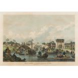
NO RESERVE France.- Paris.- Collection of 20 plans of Paris and its environs, including a large panorama 'Paris 1867' by The London Illustrated Ne...
Germany.- Wilckens (C.) Special Karte von dem Fürstenthum Hildesheim und den angrenzenden Landern, …
NO RESERVE Germany.- Wilckens (C.) Special Karte von dem Fürstenthum Hildesheim und den angrenzenden Landern, rare map of the Hildesheim principal...
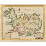
Iceland.- Bellin (Jacques Nicolas) Carte de l'Islande, pour Servir a la Continuation de l'Histoire …
Iceland.- Bellin (Jacques Nicolas) Carte de l'Islande, pour Servir a la Continuation de l'Histoire Generale des Voyages, map of Iceland, engraving...

India.- Faden (William) An Epitome Geographical and Political of Hindoostan, 1788; and two others …
NO RESERVE India.- Faden (William) An Epitome Geographical and Political of Hindoostan, engraving with hand-colouring, on Whatman wove paper, plat...
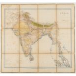
India.- Great Trigonometrical Survey of India.- Surveyor General's Office (Calcutta, India) India, …
India.- Great Trigonometrical Survey of India.- Surveyor General's Office (Calcutta, India) India, sixth edition, detailed map of India and Ceylon...

Ireland.- Heffernan (Daniel Edward) Heffernan's Illustrated Plan of Wicklow &c., tourist's map showing from Dublin in the upper right corner to Co...

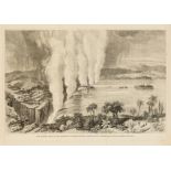
Italy.- Jefferys (Thomas) A South View of the City of Genoa, birds-eye-view showing the port and city, reference key below, from The Gentleman's M...
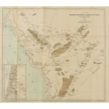
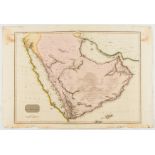
Middle East.- Doughty (Charles M.) A Map of North Western Arabia and Negd, with inset of Western Jordan, the map showing the routes of Doughty, li...
Middle East.- Cheesman (Major Robert Ernest) Arabia. Routes between 'Oqair and Jabrin Oasis in …
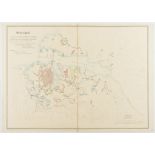
Middle East.- Cheesman (Major Robert Ernest) Arabia. Routes between 'Oqair and Jabrin Oasis in Eastern Nejd, map of an ornithological expedition i...
![Middle East.- Saudi Aramco (publisher) El Hasa, [c. 1950]; and another similar [c. 1942] (2)](https://portal-images.azureedge.net/auctions-2021/forum-10286/images/b9bf6840-3bf4-4824-a40d-adb700c81426.jpg?w=155&h=155)
Middle East.- Saudi Aramco (publisher) El Hasa, [c. 1950]; and another similar [c. 1942] (2)
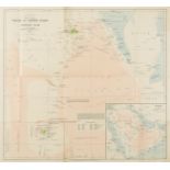
Middle East.- Saudi Aramco (publisher) El Hasa, large detailed wall map focussed on the Persian Gulf, one sheet from a larger set, lithograph on t...
Middle East.- Escape map on silk.- War Office (Geographical Section) Tabriz (verso); Tbilisi …
Middle East.- Escape map on silk.- War Office (Geographical Section) Tabriz (verso); Tbilisi (recto), "restricted" military intelligence escape ma...
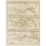
Russia.- The Crimean War.- War Department (Topographical & Statistical D.) Collection of seven …
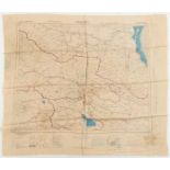
Russia.- The Crimean War.- War Department (Topographical & Statistical Depót) Collection of seven confidential maps and plans relating to The Crim...
![Spain.- Blaeu (Willem Jansz.) Catalonia, [c.1635]](https://portal-images.azureedge.net/auctions-2021/forum-10286/images/4dcc5eb1-1c30-41ed-b1f9-adb700c818c4.jpg?w=155&h=155)
NO RESERVE Spain.- Blaeu (Willem Jansz.) Catalonia, engraving on laid paper without watermark, with early hand-colouring, platemark 390 x 505 mm (...
West Indies.- Collection of 29 West Indian views and maps, including maps of Jamaica, Martinique, Dominica, Grenada, Barbados, and general maps of...
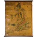
British Isles.- Geological map.- Loader (T.B.) T. B. Loader's Scientific and Commercial Map of …
NO RESERVE British Isles.- Geological map.- Loader (T.B.) T. B. Loader's Scientific and Commercial Map of England and Wales in which are delineate...
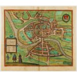
Bristol.- Braun (Georg) and Franz Hogenberg. Brightstowe vulgo quondam venta flore tissimum …
Bristol.- Braun (Georg) and Franz Hogenberg. Brightstowe vulgo quondam venta flore tissimum Angliae Emporium, engraving with original hand-colouri...
![Bristol.- Collins (Capt. Greenville) [The Severn or Channell of Bristoll], [c. 1690s].](https://portal-images.azureedge.net/auctions-2021/forum-10286/images/de5769d0-0bf3-4ca9-a9ce-adb700c7ab51.jpg?w=155&h=155)
Bristol.- Collins (Capt. Greenville) [The Severn or Channell of Bristoll], the Bristol Channel, with the city of Bristol located at the right of t...
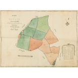
Estate Plans.- Downing (Isaac) Plan of an Estate situate at Red Hill in the Parish of Hales Owen …
Estate Plans.- Downing (Isaac) Plan of an Estate situate at Red Hill in the Parish of Hales Owen in the property of Mr. Joseph Downing occupied by...
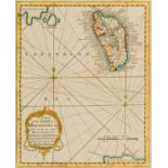
![Isle of Wight.- Speed (John) Wight Island, [c. 1676].](https://portal-images.azureedge.net/auctions-2021/forum-10286/images/159d18c5-d355-4fa5-8fb6-adb700c80fd4.jpg?w=155&h=155)
Isle of Wight.- Speed (John) Wight Island, with inset town plans of Newport and Southampton, engraving with hand-colouring, on laid paper with ind...