Filtered by:
- Category,
- Item Type
- List
- Grid
A subscription to the Price Guide is required to view results for auctions ten days or older. Click here for more information
![Board of Ordnance.- Bridges (William, politician) Certificate, Thomas Jenkins Ma[ste]r of ye …](https://portal-images.azureedge.net/auctions-2020/forum-10222/images/68debb6f-7075-4bd2-91f9-abd00126d491.jpg?w=155&h=155)

Board of Ordnance.- Bridges (William, politician) Certificate, Thomas Jenkins Ma[ste]r of ye …
NO RESERVE Board of Ordnance.- Bridges (William, politician, a member of the Board of Ordnance, d. 1714) Certificate, Thomas jenkins Ma[ste]r of ...
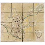
Bath.- Taylor (A.) & W. Meyler. A New and Accurate Plan of the City of Bath to the present Year, …
NO RESERVE Bath.- Taylor (A.) & W. Meyler. A New and Accurate Plan of the City of Bath to the present Year, 1801, showing the boundary of the Old ...
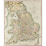
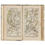
NO RESERVE Britain.- Cary (John) Cary's Reduction of His Large Map of England and Wales, with Part of Scotland, detailed map of the counties, mark...
Coach Roads.- Coltman (Nathaniel) A New Map of all the Coach Roads...of England & Wales..., …
NO RESERVE Coach Roads.- Coltman (Nathaniel) A New Map of all the Coach Roads...of England & Wales..., folding hand-coloured engraved map, c.810 x...
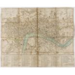
London.- Harris (John) Harris's Plan of London, Westminster and the Borough of Southwark, with all …
NO RESERVE London.- Harris (John) Harris's Plan of London, Westminster and the Borough of Southwark, with all the additional Streets, Squares &c.,...
Post Roads.- Cary (John, publisher) Cary's Actual Survey of the Great Post Roads between London and Falmouth...ascertained by A.Arrowsmith Land Su...
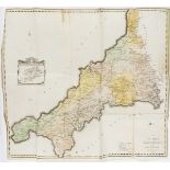
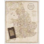
South West England.- Tunnicliff (William) A Topographical Survey of the Counties of Hants, Wilts, …
South West England.- Tunnicliff (William) A Topographical Survey of the Counties of Hants, Wilts, Dorset, Somerset, Devon, and Cornwall, first edi...
![Americas.- Weld (Isaac) Plan of the City of Washington, [c. 1798]; and 8 others (9)](https://portal-images.azureedge.net/auctions-2020/forum-10222/images/0287643d-ebdc-4dbe-acef-abd001262c4c.jpg?w=155&h=155)
NO RESERVE Americas.- [Weld (Isaac)] Plan of the City of Washington, Carl Jattnig's reduced version of the 1792 L'Enfant-Ellicott plan of the city...
![Atlantic.- [Bowen (Emanuel)] A New Map or Chart of the Western or Atlantic Ocean, with Part of …](https://portal-images.azureedge.net/auctions-2020/forum-10222/images/b2c1868a-92a2-4454-a4da-abd00126adf2.jpg?w=155&h=155)
Atlantic.- [Bowen (Emanuel)] A New Map or Chart of the Western or Atlantic Ocean, with Part of …
NO RESERVE Atlantic.- [Bowen (Emanuel)] A New Map or Chart of the Western or Atlantic Ocean, with Part of Europe Africa & America: Shewing the Cou...
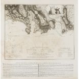
Caribbean.- Battle of St. Lucia.- Faden (William) Sketch of Part of the Island of Ste. Lucie, …
NO RESERVE Caribbean.- Battle of St. Lucia.- Faden (William) Sketch of Part of the Island of Ste. Lucie, map by Lt. G.V. Hart, assistant engineer ...

NO RESERVE Botany.- Urquhart (Beryl Leslie) The Camellia, colour plates after Raymond Boothe and Paul Jones, original half cloth, bump to fore-edg...
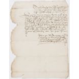
Scotland.- Campbell (Colin, sixth Earl of Argyll) Document relating to the Earl of Argyll, …
Scotland.- Campbell (Colin, sixth Earl of Argyll, magnate, c. 1542-1584) Document relating to the Earl of Argyll, manuscript in Scots English and ...
![Holland (Henry) Herōologia Anglica hoc est clarissimorum et doctissimorum. aliqout [sic] Anglorum, …](https://portal-images.azureedge.net/auctions-2020/forum-10222/images/b8789427-3a6a-4971-bcba-abd001261d1c.jpg?w=155&h=155)
Holland (Henry) Herōologia Anglica hoc est clarissimorum et doctissimorum. aliqout [sic] Anglorum, …
Holland (Henry) Herwologia Anglica hoc est clarissimorum et doctissimorum. aliqout [sic] Anglorum, 2 vol. in 1, engraved pictorial title, incorpor...
![Australia.- Tallis (John) & John Rapkin. Seven maps of Australia, [1851] (7)](https://portal-images.azureedge.net/auctions-2020/forum-10222/images/606af997-e1ca-46f7-898f-abd00125a1d1.jpg?w=155&h=155)
Australia.- Tallis (John) & John Rapkin. Seven maps of Australia, including a general map of Australia, the others of New South Wales, Victoria or...