Refine your search
Filtered by:
- Category,
- Creator / Brand
- List
- Grid
A subscription to the Price Guide is required to view results for auctions ten days or older. Click here for more information
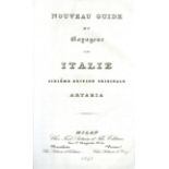

Italian Travel: Artaria (F. & Sons) Nouveau Guide du Voyageur en Italia, 8vo Milan 1841. Sixth, hf.
Italian Travel: Artaria (F. & Sons) Nouveau Guide du Voyageur en Italia, 8vo Milan 1841. Sixth, hf. title, 2 lg. folding map (1 hd. cold. in outli...
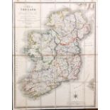
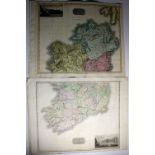
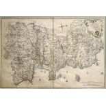
Irish Maps: Duncan (Wm.) Ireland Showing the Several Counties, Large Rivers, Canals etc., engd. hd.
Irish Maps: Duncan (Wm.) Ireland Showing the Several Counties, Large Rivers, Canals etc., engd. hd. cold. map, linen backed Dublin Castle 1848, a...
Irish Maps: Cary (John) New Map of Ireland, fold. linen backed map, hd. cold. in outline, approx.
Irish Maps: Cary (John) New Map of Ireland, fold. linen backed map, hd. cold. in outline, approx. 30" x 25", in orig. boards folder, ptd. label; a...
Irish Maps: Curry (Wm.
Irish Maps: Curry (Wm.) publisher, County of Wicklow, engraved by Sidney Hall from the Original Survey For Baldwin & Craddock D. 1834. Engd. fold....
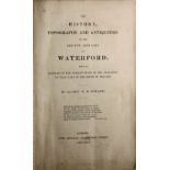
Ryland (Rev. R.H.
Ryland (Rev. R.H.) The History, Topography and Antiquities of the County and City of Waterford, 8vo L. 1824. First Edn., lg. fold. hd. cold. map, ...
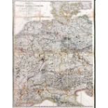
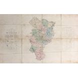
Map: Germany: Wyld (James) Map of the Central States of Europe, situate between France and Russia,
Map: Germany: Wyld (James) Map of the Central States of Europe, situate between France and Russia, describing their new Limits conforming with the...
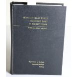
Geological Thesis Archer (Barbara Jean) Ordovician Trough Margin Sedimentary Rocks in Western
Geological ThesisArcher (Barbara Jean) Ordovician Trough Margin Sedimentary Rocks in Western Ireland, folio Galway 1975. Maps, plans & original ph...
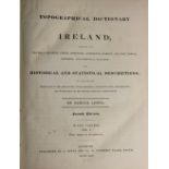
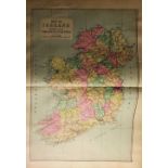
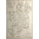
Lewis (Samuel) A Topographical Dictionary of Ireland, 2 vols. 4to L. 1849 Second Edn., plus lg.
Lewis (Samuel) A Topographical Dictionary of Ireland, 2 vols. 4to L. 1849 Second Edn., plus lg. Atlas of the Counties of Ireland, lg. 4to L. 1837....
River Barrow DrainageCo. Carlow: Manning (Rob.) Report to the Commissioners of Public Works, Ireland, on the Drainage of the Lands along the River...
![[Co. Cork] Townsend (Rev. Horatio) Statistical Survey of the County of Cork, thick 4to, D.](https://portal-images.azureedge.net/auctions-2018/srfons10034/images/5bda028d-90f3-456c-b38c-a99d00b9636a.jpg?w=155&h=155)
[Co. Cork] Townsend (Rev. Horatio) Statistical Survey of the County of Cork, thick 4to, D. (Graisberry & Campbell) 1810, First, fold. map, uncut, ...
Co. Kilkenny: Tighe (Wm.
Co. Kilkenny: Tighe (Wm.) Statistical Observations Relative to the County of Kilkenny, under the Direction of the Royal Dublin Society. 8vo D. 180...
Fraser (Robert) General View of the Agriculture and Mineralogy, Present State and Circumstances of the County of Wicklow, with Observations... for...
Kane (Elisha Kent) The U.S. Grinnell Expedition in Search of Sir John Franklin, 8vo L. 1854.
Kane (Elisha Kent) The U.S. Grinnell Expedition in Search of Sir John Franklin, 8vo L. 1854., frontis, fold. map, 13 plts. 2 single page maps, num...
Co. Kildare: Ordnance Survey - Index to the Townland Survey of the County of Kildare, lg. hd. cold.
Co. Kildare: Ordnance Survey - Index to the Townland Survey of the County of Kildare, lg. hd. cold. fold. linen backed map, D. August 1840, also S...

Co. Waterford interest: Two 18th Century engd. & hd. cold. Maps of Co. Waterford, from Scale, Taylor & Skinner & 1 other; one 19th Century Waterf...
Map: A curious antique map, The Ancient City of Syracuse in Sicily, printed on papyrus, entitled Pianta dell 'antica siracusa, marking sites of an...

Engravings & Maps: A collection of approx. 23, 18th Century engraved dbl. page City, Town & Battle Plans, mostly Continental, from Tindal's Contin...
Maps: Scull (N.) & Heap (G.) A Map of Philadelphia and Parts Adjacent, c. 1777; A Particular Map of Baffin and Hudson's Bay, c. 1760, approx. 9 1/...
Maps & Plans of Dublin: Larcom (Thos. A.) Dublin, and The County of the City of Dublin, two attractive fold. hand cold. plans from Municipal Corpo...
Northern Ireland interest: Two 18th Century Sea Charts, A Chart of the Seacoasts of Ireland form Dublin to London-Derry, and A Chart of the North-...
Limerick & Cork interest: Larcom (Thos. A.) Limerick, fold. hd. cold. map from Municipal Corporation Boundaries (Ireland), c. 1830; and three smal...
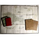
Dublin Maps: A very good collection of Maps & Plans of Dublin, mostly from Wilson's Dublin Directory, and from The Picture of Dublin, c. 1791 - 18...
Maps, Plans, Portraits etc: A portfolio, include., Boydell (John) Plan of the Town and Harbour of Mahon, St. Philip's Castle, and its Fortificatio...
Map: Thompson (James) - Ireland, Northern & Southern Parts, Plates No 10, A & B from New General Atlas, 1817. Lg. engraved fully hand coloured ma...
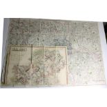
Maps: Portfolio of varied Ordnance & other Survey Maps & Plans of Dublin City & County, some from Thom's Directories, some large scale coloured ex...
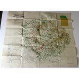
Pre-Boundary Commission Map Irish Map: Population Map of The North of Ireland, Lg. fold. cold.
Pre-Boundary Commission MapIrish Map: Population Map of The North of Ireland, Lg. fold. cold. map, approx. 74cms 88cms (29" x 34 1/2"). Published ...
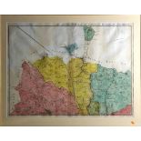
Grand Jury Map of Co. DonegalCo. Donegal: Mc Crea (Wm.) A Map of the County of Donegal, Drawn from Actual Survey .. A.D. 1801. First Edition. In f...
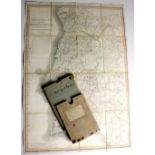
Co. Kilkenny - Estate Map for Toler-Alyward Estate Shankill, Co. Kilkenny, Lg. fold. wall map, with extensive manuscript legend listing No. of far...
Atlas: Richards & Company, Memorial Atlas of Ireland, Showing Provinces, Counties, Baronies,
Atlas: Richards & Company, Memorial Atlas of Ireland, Showing Provinces, Counties, Baronies, Parishes, Etc. Lg. atlas folio Philadelphia 1901. Dec...
Maps: Sayer & Bennett - County of Kerry, engd. map, printed Lond. 1776, hd. cold. in outline, approx. 21cms x 15cms, framed; also framed collage o...
Very Rare Dublin MapRocque (John) A Map of the County of Dublin, Divided in Barony's Reduced from An Actual Survey in four Sheets. Published in Lo...
Map: Rocque (John) An Actual Survey of the County of Dublin, by John Rocque .. Printed for Robt.
Map: Rocque (John) An Actual Survey of the County of Dublin, by John Rocque .. Printed for Robt. Laurie & Jas. Whittle, No. 53 in Fleet Street, No...
Post Office Communication with IrelandMap: House of Commons - A New Map of Ireland, Showing the Post Towns and Mail conveyances throughout togethe...
Map: Co. Cork - Port et Ville de Kingsaill en Irlande, Paris c. 1730, hd. coloured in outline, approx. 24cms x 19.5cms (91/2" x 111/2"), in hogar...
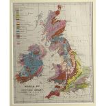
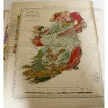
Map: Geological Map of The British Isles, fully coloured, c. 1870, approx. 25cms x 20cms (8" x 10"), framed. (1)
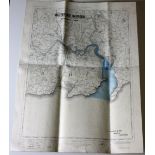
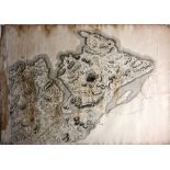
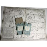
![Map: Down Survey - Co. Limerick [Petty (Sir Wm.)] The County of Limerick, c.](https://portal-images.azureedge.net/auctions-2018/srfons10034/images/fdf667d0-d0b8-4774-96d4-a99d00bacfd4.jpg?w=155&h=155)
Map: Down Survey - Co. Limerick [Petty (Sir Wm.)] The County of Limerick, c. 1700, with engraved cartouche approx. 41cms x 51cms (16 1/4" x 20"), ...
![Map: Down Survey - Co. Westmeath: [Petty (Sir Wm.)] The County of West Meath, c.](https://portal-images.azureedge.net/auctions-2018/srfons10034/images/5df0de05-c8c4-45f0-8072-a99d00bad0b4.jpg?w=155&h=155)
Map: Down Survey - Co. Westmeath: [Petty (Sir Wm.)] The County of West Meath, c. 1700, with engraved cartouche, approx. 41cms x 51cms (16 1/4" x 2...
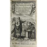
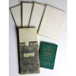
With Engraved Folding MapsElzevir Press: Cluverius (Philip) Introductionis in Universam Geographiam.. Tabulis aereis illustrata.... P. Bertii 16mo...
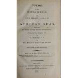
Travel: St. Vincent (J.B. G.M.
Travel: St. Vincent (J.B. G.M. Bory de) Voyage to, and Travels Through the Four Principal Islands of the African Seas, Performed by Order of the F...
Map: Langlois (Hyacinthe)publ.
Map: Langlois (Hyacinthe)publ. Atlas Portatif et Itineraire de L'Europe, pour servir d'intelligence au guide des voyageurs dans partie du Monde. R...
Map: Faden (Wm.) Plan of The Harbour of Cadiz: Surveyed by Brig. Don Vincent Tofino de San Miguel.
Map: Faden (Wm.) Plan of The Harbour of Cadiz: Surveyed by Brig. Don Vincent Tofino de San Miguel. fold. linen backed engd. plan, approx. 53cms 88...
Maps - Paris: Girard (X.) Plan de la Ville de Paris, lg. linen backed map, hd. cold. in outline, approx. 60cms x 100cms (24" x 39"), Paris (J. Gou...
Maps: Whittle (J.A.) & Rich. Holmes Laurie, Ireland. Anciently Erin,: Ierne: Hiberna: Large lined backed fold. map, full cont. hand colouring, app...

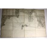
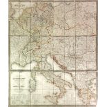
Map - Italy: Carte Statistique, Politique, et Mineralogique de L'Italie, ou sont Fracees toutes les routes, relais, et distances de postes et les ...

Maps - Rome etc: Westphal (Gio.
Maps - Rome etc: Westphal (Gio. Enrico) Carta Topografica (+ Guida) della parte piu interessante della Campagna di Roma, lg. linen backed engd. ch...
Maps: Portugal - Faden (Wm.)ed.
Maps: Portugal - Faden (Wm.)ed. Mappa Corographica de Reino de Portugal - Chorographical Map of the Kingdom of Portugal Divided into its Grand Pro...
Maps - France etc: Faden (Wm.)publ. The French Empire and the Kingdom of Italy with Part of the States of the Confederation of the Rhine From Lapi...
Maps: Rome - Vasi - Calcographie d'Estampes, Nouveau Plan de Rome Moderne, and Nouveau Plan de Rome Ancienne, By Louis Nicoletti, 2 engd. fold. l...
Maps - Germany: de Traux (Max) Neueste General und Post-Karte von ganz Deutschland und Italien nit
Maps - Germany: de Traux (Max) Neueste General und Post-Karte von ganz Deutschland und Italien nit Inbegriff aller Provinzen der Desterreichischen...
Maps: - Rome etc: Monaldini (V.) publ. Pianta Della Citta di Rome con la Indicazione di tutte le antichita e nuovi abbellimenti Publicata in Roma ...

Maps: Italy etc: Orgiazzi (J.A.
Maps: Italy etc: Orgiazzi (J.A.) A Statistical, Political and Mineralogical and Modern Map of Italy, lg. fold linen backed hd. cold.map, 8vo Londo...
Maps: Artaria & Co.
Maps: Artaria & Co. - Carte de la Monarchie Austrichienne et des Etats en Italie possedes par les Princes & Princesses d'Austriche d'Apres le Cong...

Maps: Wyld (James) Map of the Ottoman Empire, The Black Sea and The Frontiers of Russian and Persia,
Maps: Wyld (James) Map of the Ottoman Empire, The Black Sea and The Frontiers of Russian and Persia, fold. cold. linen backed map, London c. 1853,...
Map - Pyrenees: Arrowsmith (A.
Map - Pyrenees: Arrowsmith (A.) A Map of the Pyrenees and the Adjacent Provinces by Roussel and Blottiere, V. large linen backed fold. map, fully ...
Map - Spain & Portugal: Natiat (Jasper) A Map of Spain and Portugal, Exhibiting The Chains of Mountains, with Their Passes... V. large fold. linen...
Co. Kerry Map: Griffith (R.) Index to the Townland Survey of the County of Kerry, lg. folding linen backed map, full cont. hd. colouring, D. c. 18...
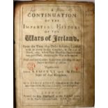
Story (Geo.) A Continuation of the Impartial History of the Wars of Ireland, 4to L. 1693., fold.
Story (Geo.) A Continuation of the Impartial History of the Wars of Ireland, 4to L. 1693., fold. maps, soiled; Temple (John) The Irish Rebellion, ...
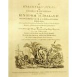
Scale (Bernard) An Hibernian Atlas; or General Description of the Kingdom of Ireland. 4to L. 1798.
Scale (Bernard) An Hibernian Atlas; or General Description of the Kingdom of Ireland. 4to L. 1798. First Edn., engd. title with vignette, engd. Pr...
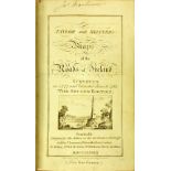
Taylor (G.
Taylor (G.) & Skinner (Andrew) Maps of the Roads of Ireland, Surveyed in 1777 and Corrected Down to 1783. Roy 8vo L. 1783. Second & Best Edition, ...