Filtered by:
- Sale Section,
- Item Type
- List
- Grid
A subscription to the Price Guide is required to view results for auctions ten days or older. Click here for more information
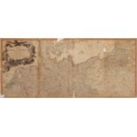

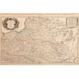
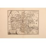
A late 18th Century Map of the Empire of Germany by Delarochette , including all the states comprehended under that name: with the Kingdom of Prus...
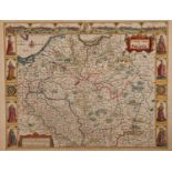
A John Speed, 17th Century Map of Poland, Speed, John (1552-1629). 17th-Century map of Poland, hand-coloured copper engraving, featuring inset cit...
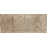
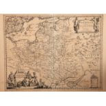
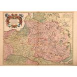
A Late 18th Century Map of The European Part of the Russian Empire, late 18th Century map of "The European Part of the Russian Empire, The Asiatic...
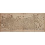
A Late 18th Century Map of The European Part of the Russian Empire, late 18th Century map of "The European Part of the Russian Empire, The Asiatic...
An Early 17th Century plan of Warsaw, Kraków & Vilna, Chatelain, Henry Abraham, 'Carte des Trois Ordres qui Composent l'Etat de la Republique de P...
An Early 17th Century Panorama of Lowicz, Poland, Georg Braun (1541-1622) Franz Hogenberg (1535-1590), 'Lovicensis Civitas quae est Archiepiscopa...
An Early 17th Century Panorama of Lowicz, Poland, Georg Braun (1541-1622) Franz Hogenberg (1535-1590), 'Lovicensis Civitas quae est Archiepiscopa...
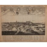
An 17th Century Panorama of Kraków, Poland, copperplate panorama from Atlas Van der Hagen, published by Johannes Janssonius (1588-1664), titled 'C...
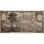
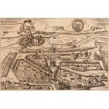
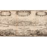
A 17th Century Panorama of Warsaw in the Polish-Swedish War, copperplate engraved panorama showing the first day of the battle for Warsaw in the P...
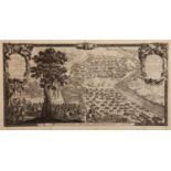
A Collection of 6 Plates of The Polish-Swedish War of 1656, Coperplate panoramas from 'de rebus a Carolo gustavo Sueta rege ..." printed in 1696, ...
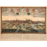
A 17th Century Panorama of Cracovie Poland, Copper engraved panorama titled 'CRACOVIE' hand coloured, with all important buildings labeled, date i...
A 16th Century Woodcut Map of Poland, Lithuania, the Ukraine, Moscovy Moscow and the Balkans,
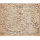
A 16th Century Woodcut Map of Poland, Lithuania, the Ukraine, Moscovy and the Balkans, Munster, c.1540, Woodcut map titled 'Polonia et Ungaria XV ...
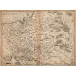
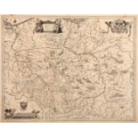
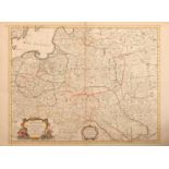
A Large Scale 17th Century Map of Poland and Surrounding Countries, SANSON, N and JAILLOT, A.H., Paris 1685, titled 'Les Estates de Couronnede de ...
A 16th Century Map of Poland,
A 16th Century Map of Poland, A Braham Ortelius, published in Antwerp, c.1584, decorated with a sailing ship on the sea and a cartouche, latin tex...
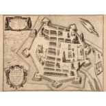
A 17th Century Map of Zamosc in Poland, Braun & Hogenberg, C.1618, titled 'Zamoscium. Nova Poloniae civitas, à magnifico eius regni Cancellaro à f...
Two Early Maps of Poland,
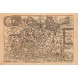
Two Early Maps of Poland, Matthaus Quad, Printed in Cologne, c.1592, detailed map of Southern Poland and the from the Weysel River in the north to...
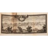
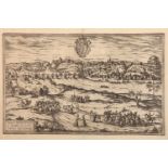
A 17th Century View of Warsaw from Across The Vistula River, Pufendorf, Samuel von, 1656, Nuremburg, with title in cartouche which reads 'Urbs War...
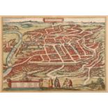
A 16th Century Map of Vilnius, Lithuania, Braun & Hogenberg, 1599, map title 'VILNA LITVANIAE' hand coloured, 53cm x 42cmNote: from first latin ed...
A 17th Century Bird's-eye View of Lviv in Ukraine, Georg Braun and Frans Hogenberg, c.1617, cartouche in the centre reads 'Leopolis Russiae Austra...
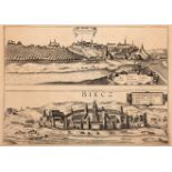
A 17th Century Bird's-eye view of Sandomierz & Biecz, Poland, Georg Braun and Frans Hogenberg, c.1617, with bird's-eye view of Sendomiria at top, ...
A 17th Century Bird's-eye View of Grodno in Lithuania, Georg Braun and Frans Hogenberg, c.1617, with bird's-eye view of Grodna, cartouche to botto...
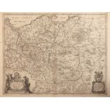
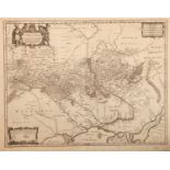
An 18th Century Map of the Polish Empire, Extending South to the Black Sea, Henri Abraham Chatelain (1684-1743), Paris 1712, title reads 'Carte De...
A 17th Century Map of Poland, lithuania, Ukraine, Prussia, Johannes de Ram, c.1690, titled 'Regni Poloniae et Ducatus Lithuaniae Volhyniae, Podoli...
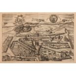
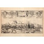
A 17th Century Bird's-Eye View of Torun in Kujawien-Pommern at the Vistula Riber in Poland, Pufendorf, Samuel Baron von, Published in Nürnberg, C....
An 18th Century Map of Poland & Prussia, Pieter van der Aa (1659-1733), published Leiden, C.1715, cartouche to bottom left corner reads 'Palatinat...
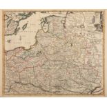
A Late 17th Century Map of Poland, Prussia, Lithuania and Ukraine, Nicolaas Visscher after N. Sanson, c.1690, decorative cartouche showing two win...
A 17th Century Decorative Map of Poland, Including Coats of Arms, Cherubs and cartouchees, Willem Janszoon Blaeu (1571-1638), Published in Amsterd...
A 17th Century Map of Poland,
A 17th Century Map of Poland, J. Janssonius - Moses Pitt, c.1680, cartouche reads 'Novissima POLONIAE REGNI descriptio, copper engraving hand col...
One of the Earliest Printed Maps of Ukraine, Moses Pitt, c.1680, cartouchee reads 'Typus Generalis Ukrainae sive Palatinatuum Podoliae, Kioviensis...
An 18th Century Map of Poland,
An 18th Century Map of Poland, Guillaume De L'Isle, published paris, c.1702, with cartouche which reads 'La Pologne Dressee sur ce qu'en ont donne...
An 18th Century Detailed map of the Polish Empire, published by John Senex, John Senex, Published London, c.1719, cartouche reads 'Poland and othe...
A Map of Asia, Edward Wells,
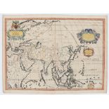
A Map of Asia, Edward Wells, Edward Wells, c.1738, cartouche reads 'A New Map of Ancient Asia ..', copper plate, hand coloured, Note: from "A New ...
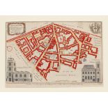
Two Early English Maps,
Two Early English Maps, Two Early Maps, the first Benjamin Cole's detailed ward plan from William Maitlands history and survey of London, 1756, th...
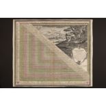
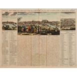
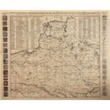
A Large Table of Distances Between European Cities, Matthäus Seutter (1678 - 1756), Published in Germany, titled ' POLIOMETRIA GermanIAE, AC FINIT...
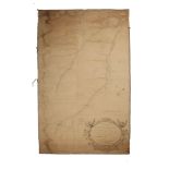
A Large Hand-Drawn Map of Mining Operations in Hexham, with cartouche that reads 'PLAN of WEST ALLENDALE from Blackpool Bridge to Kilhope Law PART...
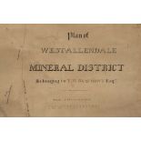
A Large Hand-Drawn Map of Mining Operations in Hexham, titled 'Plan of WEST-ALLENDALE MINERAL DISTRICT Belonging to T. W. BEAUMONT Esq', probably ...