Refine your search
Filtered by:
- Category,
- Creator / Brand
- List
- Grid
A subscription to the Price Guide is required to view results for auctions ten days or older. Click here for more information
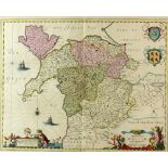

Map of part of North Wales by Schenk and Vale, 40 x 50 cms framedProvenance; this lot is being sold
Map of part of North Wales by Schenk and Vale, 40 x 50 cms framedProvenance; this lot is being sold on behalf of the Royal Star and Garter Homes ...
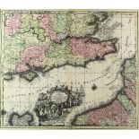
Mathieu Seuter 1678-1757, Map, La plus grande partiede la Manche qui contient les cotes d'Angleterre
Mathieu Seuter 1678-1757, Map, La plus grande partiede la Manche qui contient les cotes d'Angleterre et celles de France, framed, 48 x 57cmsProven...
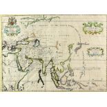
A New Map of Ancient Asia, Edward Wells (1667 - 1727) Coloured map of the Asian Continent. Printed
A New Map of Ancient Asia, Edward Wells (1667 - 1727) Coloured map of the Asian Continent. Printed in London by E. Wells circa 1738. 38cm x 51cm ....
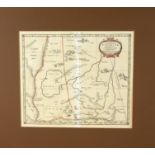
Tab. VII. Asiae, Exhibens Scythiam, intra Imaum Sogdianam, Bactrianam, Hircaniam, aliasq. Asiae Regiones?, Johannes 'John' Norden (c.1547-1625) Br...
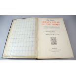
The Times Survey Atlas of The World; A Comprehensive Series of New and Authentic Maps Reduced from
The Times Survey Atlas of The World; A Comprehensive Series of New and Authentic Maps Reduced from the National Surveys of the World and The Speci...
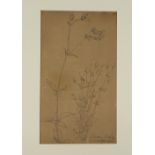
Manner of P. C. Skovgaard, Sandgraven Ved Weibly, ink, dated 1843, 32cm x 18cm .