Filtered by:
- Sale Section,
- Creator / Brand
- List
- Grid
A subscription to the Price Guide is required to view results for auctions ten days or older. Click here for more information
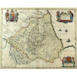

P Schenk and G Vale, map of the bishoprike of Durham, Episcopatus Dunelmensis, with royal coat of
P Schenk and G Vale, map of the bishoprike of Durham, Episcopatus Dunelmensis, with royal coat of arms, framed, 43 x 50 cmsProvenance; this lot is...
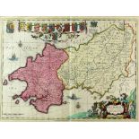
Map Penbrochia Caermadinium by Schenk and Vale, with coats of arms, 39 x 50 cms framedProvenance;
Map Penbrochia Caermadinium by Schenk and Vale, with coats of arms, 39 x 50 cms framedProvenance; this lot is being sold on behalf of the Royal St...
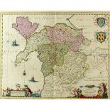
Map of part of North Wales by Schenk and Vale, 40 x 50 cms framedProvenance; this lot is being sold
Map of part of North Wales by Schenk and Vale, 40 x 50 cms framedProvenance; this lot is being sold on behalf of the Royal Star and Garter Homes ...
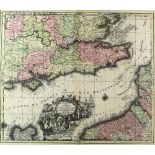
Mathieu Seuter 1678-1757, Map, La plus grande partiede la Manche qui contient les cotes d'Angleterre
Mathieu Seuter 1678-1757, Map, La plus grande partiede la Manche qui contient les cotes d'Angleterre et celles de France, framed, 48 x 57cmsProven...
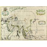
A New Map of Ancient Asia, Edward Wells (1667 - 1727) Coloured map of the Asian Continent. Printed
A New Map of Ancient Asia, Edward Wells (1667 - 1727) Coloured map of the Asian Continent. Printed in London by E. Wells circa 1738. 38cm x 51cm ....
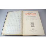
The Times Survey Atlas of The World; A Comprehensive Series of New and Authentic Maps Reduced from
The Times Survey Atlas of The World; A Comprehensive Series of New and Authentic Maps Reduced from the National Surveys of the World and The Speci...