Refine your search
Estimate
Category
- Maps (120)
- Prints & Multiples (51)
- Books, Manuscripts & Periodicals (23)
- Entertainment Memorabilia (12)
- Collectables (5)
- Photographs (3)
- Stamps (3)
- Arms, Armour & Militaria (2)
- Drawings & Pastels (2)
- Bank notes (1)
- Ethnographica & tribal art (1)
- Musical Instruments & Memorabilia (1)
- Silver & Silver-plated items (1)
- Sporting Memorabilia & Equipment (1)
- Vintage Fashion (1)
- Watercolours (1)
Creator / Brand
- John Speed (9)
- Robert Morden (9)
- Thomas Kitchin (9)
- Blaeu (8)
- Christopher Saxton (8)
- Emanuel Bowen (7)
- Jan Jansson (7)
- Joan Blaeu (7)
- John Cary (7)
- Charles Smith and Son (6)
- Thomas Moule (6)
- Herman Moll (3)
- Jacques Nicolas Bellin (3)
- Philip Lea (3)
- William Hogarth (3)
- Dider Robert de Vaugondy (2)
- Emslie (2)
- French School (2)
- John Ogilby (2)
- John Seller (2)
- Thomas Bowen (2)
- Aaron Arrowsmith (1)
- Abraham Ortelius (1)
- Canaletto (1)
- Charles (1)
- Charles Williams (1)
- Crystal Palace (1)
- English School (1)
- Finland (1)
- Frank Sternberg (1)
- George Morland (1)
- George Philip and Son (1)
- Gerard Mercator (1)
- Giovanni Battista Piranesi (1)
- Greenvile Collins (1)
- James Gillray (1)
- John Arrowsmith (1)
- John Bayly (1)
- John Gibson (1)
- John Walker (1)
- John Wood (1)
- Mercator (1)
- Ortelius (1)
- Peter Paul Rubens (1)
- Pierre Mortier (1)
- Richard William Seale (1)
- Roussel and Blottiere (1)
- Thomas Rowlandson (1)
- Wenceslaus Hollar von Prachna (1)
- William Faden (1)
- William Lionel Wyllie (1)
Item Type
- Map (119)
- 15th-18th Century Art (25)
- 19th-21st Century Art (17)
- Poster (11)
- Atlas (8)
- Photograph (4)
- Road map (4)
- Book (3)
- Letter (3)
- Ordnance survey map (3)
- Photograph album (3)
- Theatre Poster (3)
- Cartographers and Mapmakers (2)
- Celestial Chart (2)
- Programme (2)
- Autograph (1)
- Comic (1)
- Comics (1)
- Dictionary (1)
- Encyclopedia (1)
- First Day Cover (1)
- Folio (1)
- Magazine (1)
- Magazines (1)
- Periodical (1)
- Periodicals (1)
- Planisphere (1)
- Postcard (1)
- Radio (1)
- Sheet Music (1)
- Sketchbook (1)
- Stamp (1)
- List
- Grid
A subscription to the Price Guide is required to view results for auctions ten days or older. Click here for more information
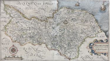

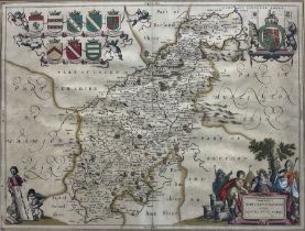
Gulielmus Hole (British ?-1624) and Christopher Saxton (British 1540-1610): 'Eboracensis Comitatus p
Gulielmus Hole (British ?-1624) and Christopher Saxton (British 1540-1610): 'Eboracensis Comitatus pars Septentrionalis vulgo North Riding', 17th ...
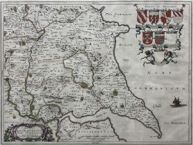
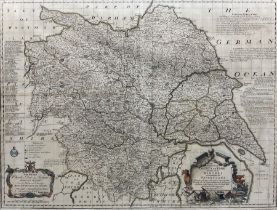
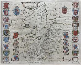
Johannes (Joan) Blaeu (Dutch 1596-1673): 'Ducatus Eboracensis Pars Orientalis - the Eastriding of Yo
Johannes (Joan) Blaeu (Dutch 1596-1673): 'Ducatus Eboracensis Pars Orientalis - the Eastriding of Yorkeshire (East Riding of Yorkshire)', 17th cen...
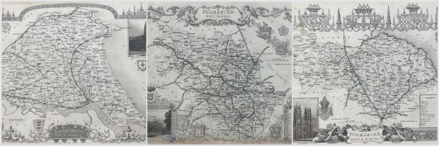
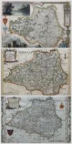
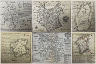
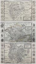
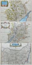
Thomas Moule (British 1785-1854): 'Yorkshire East Riding' 'Yorkshire North Riding' and 'Yorkshire We
Thomas Moule (British 1785-1854): 'Yorkshire East Riding' 'Yorkshire North Riding' and 'Yorkshire West Riding', set three 19th century engraved ma...
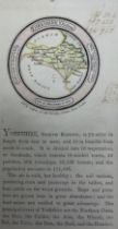
John Luffman (British 1751-1821): 'Yorkshire - North Riding', rare early 19th century miniature engraved map with original hand-colouring pub. 'Ne...
Emanuel Bowen (British 1694-1767): 'An Accurate Map of the County of York Divided into its Ridings a
Emanuel Bowen (British 1694-1767): 'An Accurate Map of the County of York Divided into its Ridings and Subdivided into Wapontakes', 18th century e...
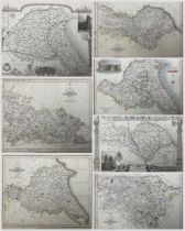
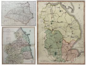
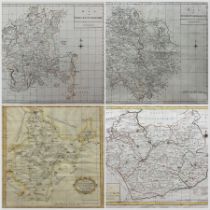
John Cary (British 1754-1835): 'North Riding of Yorkshire' 'North Plan of the West Riding' South Par
John Cary (British 1754-1835): 'North Riding of Yorkshire' 'North Plan of the West Riding' South Part of the West Riding' and 'East Riding', set f...
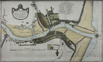
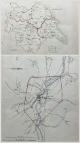
L Charlton (British 18th century): 'Plan of the Town and Harbour of Whitby', 18th century engraved map with hand-colouring pub. c1778, 28cm x 48cm
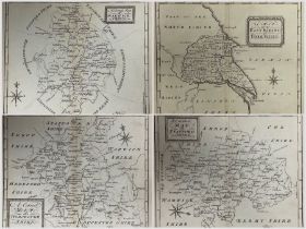
Thomas Osborne (British ?-1767): 'A Correct Map of the East Riding of Yorkshire' 'Rutlandshire' 'Shr
Thomas Osborne (British ?-1767): 'A Correct Map of the East Riding of Yorkshire' 'Rutlandshire' 'Shropshire' 'Staffordshire' 'Warwickshire' and 'W...
Thomas T Clerk (British 18th-19th century): 'Atlantic Islands' - Cape Verde, Canary, Azore and Madeira Islands, early 19th century engraved map wi...
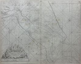
Captain Greenville (Greenvile) Collins (British 1643-1694): 'The River Humber', showin Hull and coasts of Yorkshire and Lincolnshire, 17th/18th ce...
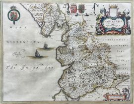
Johannes (Joan) Blaeu (Dutch 1596-1673): 'Lancastria Palatinatus Anglis Lancaster et Lancas Shire' (
Johannes (Joan) Blaeu (Dutch 1596-1673): 'Lancastria Palatinatus Anglis Lancaster et Lancas Shire' (Lancashire), 17th century engraved map with ha...
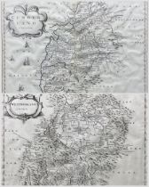
Robert Morden (British c.1650-1703): 'Westmorland' and 'Cumberland', pair 17th/18th century engraved maps pub. 'Camden's Britannia' London c1695, ...
Thomas Conder (British 1747-1831): 'Durham', 18th century engraved map with hand colouring pub. Alex Hogg c1784, 18cm x 22cm; Thomas Kitchin (Brit...
George Bickham (British 1684-1758): Perspective Map of County 'Durham', rare 18th century engraving pub. c1749, 24cm x 16cm
Collection of 18th and 19th century engraved maps of Nottinghamshire, Staffordshire, Warwickshire, Lincoln, Durham, Northumberland and the Isles o...
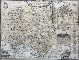
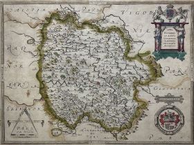
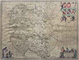
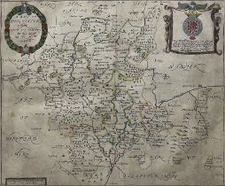
John Speed (British 1552-1629): 'Herefordshire described. with the true plot of the citie Hereford a
John Speed (British 1552-1629): 'Herefordshire described. with the true plot of the citie Hereford as alsoe the arms of those Nobles that have bee...
John Speed (British 1552-1629): 'Herefordshire described with the true plot of the citie Hereford as
John Speed (British 1552-1629): 'Herefordshire described with the true plot of the citie Hereford as alsoe the arms of those Nobles that have been...
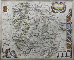
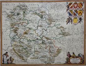
Johannes (Joan) Blaeu (Dutch 1596-1673): 'Herefordia Comitatus (Herefordshire)', 17th century engraved map with hand-colouring, first edition pub....
Johannes (Joan) Blaeu (Dutch 1596-1673): 'Herefordia Comitatus (Herefordshire)', 17th century engraved map with hand-colouring pub. Amsterdam c164...
Johannes (Joan) Blaeu (Dutch 1596-1673): 'Herefordia Comitatus (Herefordshire)', 17th century engraved map, pub. Amsterdam 1646, French bookplate ...
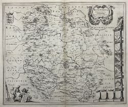
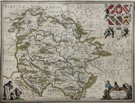
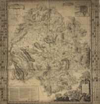
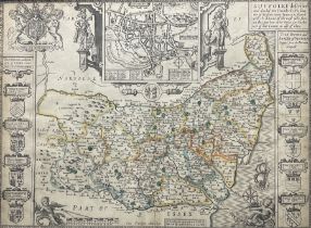
Christopher Saxton (British 1543-1610): 'Frugiferi ac Ameni Herefordiae Comitatus Delinlatio'
Christopher Saxton (British 1543-1610): 'Frugiferi ac Ameni Herefordiae Comitatus Delinlatio', 16th century engraved map of Herefordshire with han...
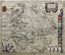
Jan Jansson (Dutch 1588-1664): 'Herefordia Comitatus Vernacule - Herefordshire', 17th century engraved map with hand-colouring, pub. Amsterdam 164...
Jan Jansson (Dutch 1588-1664): 'Herefordia Comitatus Vernacule - Herefordshire', 17th century engraved map with hand-colouring, pub. Amsterdam c16...
Jan Jansson (Dutch 1588-1664): 'Herefordia Comitatus Vernacule - Herefordshire', 17th century engraved map with hand-colouring, pub. Amsterdam 164...
Jan Jansson (Dutch 1588-1664): 'Herefordia Comitatus Vernacule - Herefordshire', 17th century engraved map with hand-colouring, pub. Amsterdam 164...
William Hole (British ?-1624) and Christopher Saxton (British c1540-c 1610): 'Frugiferi ac ameni Her
William Hole (British ?-1624) and Christopher Saxton (British c1540-c 1610): 'Frugiferi ac ameni Herefordiae comitatus qui olim pars suit Silurum ...
William Hole (British ?-1624) and Christopher Saxton (British c1540-c 1610): 'Frugiferi ac ameni Her
William Hole (British ?-1624) and Christopher Saxton (British c1540-c 1610): 'Frugiferi ac ameni Herefordiae comitatus qui olim pars suit Silurum ...
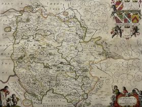
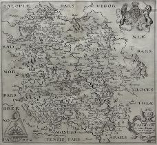
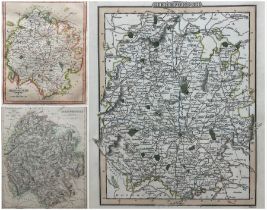
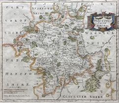
Emanuel Bowen (British 1694-1767): 'An Accurate Map of Herefordshire divided into its Hundreds'
Emanuel Bowen (British 1694-1767): 'An Accurate Map of Herefordshire divided into its Hundreds', 18th century engraved map with hand-colouring, pu...
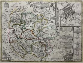
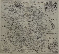
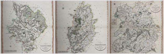
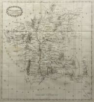
Isaac Taylor (British 1730-1807) and Thomas Kitchin (British 1719-1784): 'New Map of the County of H
Isaac Taylor (British 1730-1807) and Thomas Kitchin (British 1719-1784): 'New Map of the County of Hereford', very rare 18th century engraved map ...
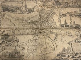
J Taylor (British 18th century) and Richard Benning (British 18th century): 'City of Hereford'
J Taylor (British 18th century) and Richard Benning (British 18th century): 'City of Hereford', very rare 18th century engraved map on rolled canv...
Robert Morden (British c.1650-1703): 'Nottinghamshire' 'Gloucestershire' 'Herefordshire' and 'Lincol
Robert Morden (British c.1650-1703): 'Nottinghamshire' 'Gloucestershire' 'Herefordshire' and 'Lincolnshire', set four '17th/18th century engraved ...
Carington Bowles (British 1724-1793): 'Bowles's Reduced Map of Worcestershire' and 'Bowles's New Med
Carington Bowles (British 1724-1793): 'Bowles's Reduced Map of Worcestershire' and 'Bowles's New Medium Map of Herefordshire', two 18th century en...
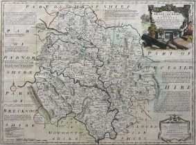
Richard Blome (British 1635-1705): 'A Mapp of Ye County of Hereford with its Hundreds', 17th century engraved map pub c1673, 19cm x 24cm; Thomas B...
James Webb (British 19th century): 'Map of Deerfold and other Estates in the Parish of Lincoln in th
James Webb (British 19th century): 'Map of Deerfold and other Estates in the Parish of Lincoln in the County of Hereford', very rare 19th century ...
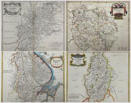
John Cary (British 1754-1835): 'Nottinghamshire' 'Huntingdonshire' and 'Shropshire', set three early 19th century engraved maps with hand-colourin...
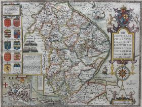
John Speed (British 1552-1629): 'The Countie and Citie of Lyncolne Described with the Armes of them
John Speed (British 1552-1629): 'The Countie and Citie of Lyncolne Described with the Armes of them that have bene Earles thereof since the Conque...
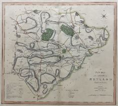
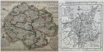
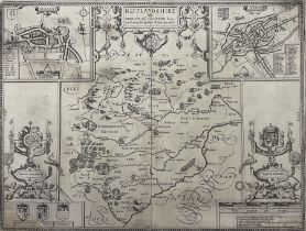
Charles Smith (British 1768-1854): 'A New Map of the County of Rutland', 19th century engraved map with hand-colouring pub. 1808 (2nd edition), 45...
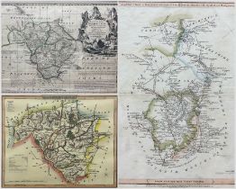
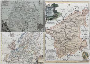
Herman Moll (Dutch/British 1654-1732): 'Worcestershire (3)' 'Rutlandshire' and 'Herefordshire'
Herman Moll (Dutch/British 1654-1732): 'Worcestershire (3)' 'Rutlandshire' and 'Herefordshire', set three 18th century engraved maps one with hand...
Robert Morden (British c.1650-1703): 'Comitatus Rotelandiae tabula Nova & Aucta' (Rutland) and 'Worc
Robert Morden (British c.1650-1703): 'Comitatus Rotelandiae tabula Nova & Aucta' (Rutland) and 'Worcestershire', two 17th/18th century engraved ma...
Robert Morden (British c.1650-1703): 'Comitatus Rotelandiae tabula Nova & Aucta' (Rutland) 'Shropshi
Robert Morden (British c.1650-1703): 'Comitatus Rotelandiae tabula Nova & Aucta' (Rutland) 'Shropshire' (2) 'Herefordshire' (2 -regular and miniat...
John Haywood (British fl.1781-1792) and Edward Sudlow (British fl.1784-1793): 'Map of Worcestershire
John Haywood (British fl.1781-1792) and Edward Sudlow (British fl.1784-1793): 'Map of Worcestershire' 'Herefordshire' and 'Leicester & Rutland', t...
John Speed (British 1552-1629): 'Rutlandshire with Oukham and Standford', 17th century engraved map pub. 'The Theatre of the Empire of Great Brita...
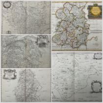
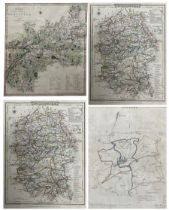
Collection of 18th and 19th century maps of Rutlandshire and Radnorshire including those by Thomas K
Collection of 18th and 19th century maps of Rutlandshire and Radnorshire including those by Thomas Kitchin, John Alken, Joseph Ellis, Thomas Moule...
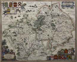
Jan Jansson (Dutch 1588-1664): Wigorniensis comitatus cum Warwicensi, nec non Conventriae Libertas' (Warwickshire), 17th century engraved map with...
Jan Jansson (Dutch 1588-1664): 'Comitatus Northantonensis vernacule Northampton Shire' (Northamptons
Jan Jansson (Dutch 1588-1664): 'Comitatus Northantonensis vernacule Northampton Shire' (Northamptonshire), 17th century engraved map with hand-col...
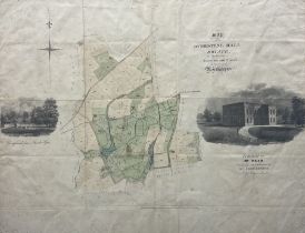
English School (19th century): Map of the Overstone Hall Estate in the Parishes of Overstone and Syw
English School (19th century): Map of the Overstone Hall Estate in the Parishes of Overstone and Sywell in the County of Northampton, engraved map...
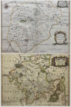
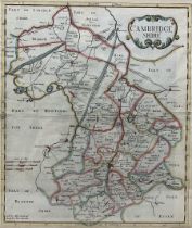
Johannes (Joan) Blaeu (Dutch 1596-1673): 'Cantabrigiensis Comitatus - Cambridge Shire', 17th century engraved map of Cambridgeshire with hand-colo...
Robert Morden (British c.1650-1703): 'Cambridgeshire', first edition 17th century engraved map pub.1695, 42cm x 36cm
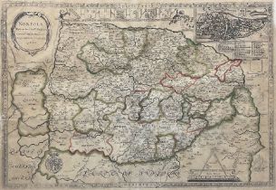
Philip Lea (British fl.1683-1700) and Christopher Saxton (British c1540-c 1610): 'Norfolk', rare 17th century engraved map with hand-colouring pub...
Robert Morden (British c.1650-1703): 'The County of Monmouth' Gloucestershire' and 'Suffolk'
Robert Morden (British c.1650-1703): 'The County of Monmouth' Gloucestershire' and 'Suffolk', set three 17th/18th century engraved maps with hand ...
John Speed (British 1552-1629): 'Suffolke Described and Divided into Hundreds, The Situation of the fayre towne Ipswich shewed, with the Armes of ...
Collection of 18th and 19th century engraved maps of Wiltshire, Gloucester, Essex and Shropshire including John Smeaton (British 1724-1792): 'A Ge...
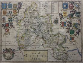
Philip Lea (British fl.1683-1700) and Christopher Saxton (British c1540-c 1610): 'A Map of Oxfordshi
Philip Lea (British fl.1683-1700) and Christopher Saxton (British c1540-c 1610): 'A Map of Oxfordshire With the Roads' with the arms of the colle...
Philip Lea (British fl.1683-1700) and Christopher Saxton (British c1540-c 1610): 'Worcestershire and
Philip Lea (British fl.1683-1700) and Christopher Saxton (British c1540-c 1610): 'Worcestershire and Citty exactly described by CS newly augmented...
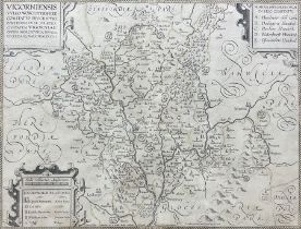
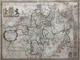
William Smith (British 1546-1618): 'Vigorniensis vulgo Worcestershire comitatus descriptio'
William Smith (British 1546-1618): 'Vigorniensis vulgo Worcestershire comitatus descriptio', 17th century engraved map, pub. Peter Stent c1603, 35...
Emanuel Bowen (British 1694-1767): 'An Accurate Map Of The County Of Worcester Divided Into Its Hund
Emanuel Bowen (British 1694-1767): 'An Accurate Map Of The County Of Worcester Divided Into Its Hundreds', 18th century engraved map with hand-col...
Richard Blome (British 1635-1705): 'A Mapp of Worchestershire With Its Hundreds' (Worcestershire)
Richard Blome (British 1635-1705): 'A Mapp of Worchestershire With Its Hundreds' (Worcestershire), 17th century engraved map with hand-colouring ...
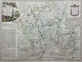
Robert Morden (British c.1650-1703): 'Worcestershire', first edition 17th century engraved map with hand-colouring pub.1695, 36cm x 42cm
T Nash (British 18th century): 'Worcestershire', rare 18th century engraved folding map pub. 'History of Worcestershire' 1781, 56cm x 52cmConditio...
Thomas Kitchin (British 1719-1784): 'Europe Drawn form the Best Authorities' 'Herefordshire' 'Worces
Thomas Kitchin (British 1719-1784): 'Europe Drawn form the Best Authorities' 'Herefordshire' 'Worcestershire Drawn from the best authorities' (3) ...