Filtered by:
- Category
- List
- Grid
A subscription to the Price Guide is required to view results for auctions ten days or older. Click here for more information

Cary's New and Correct English Atlas with forty six engraved county maps with hand coloured outline
Cary's New and Correct English Atlas with forty six engraved county maps with hand coloured outline and general map 'South Britain' published 1793...
Cary's New Map of England and Wales with part of Scotland, engraved maps with hand coloured outline
Cary's New Map of England and Wales with part of Scotland, engraved maps with hand coloured outline published 1794 with morocco and marbled boards...
Cary's New Itinerary published 1817 in tree calf, Letts's folding cycling map of England and Wales,
Cary's New Itinerary published 1817 in tree calf, Letts's folding cycling map of England and Wales, Harmsworth Atlas folding Motor Map of the Brit...
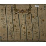
John Ogilby (1600-1676) - The Extended Road from Oakham to Richmond Yorkshire and the Continuation o
John Ogilby (1600-1676) - The Extended Road from Oakham to Richmond Yorkshire and the Continuation of the Extended Road from Oakeham to Richmond h...
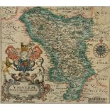
Christopher Saxton hand coloured map, Derbyshire, from Saxton's Britannica, 28cm x 32cm - Condition Report ...[more]
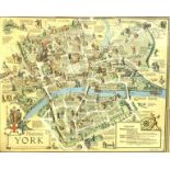
After Estra Clark (British 1904-1993): 'Historic York', colour map pub. Ben Johnson & Co, York 1947,
After Estra Clark (British 1904-1993): 'Historic York', colour map pub. Ben Johnson & Co, York 1947, - Condition Report ...[more]