Filtered by:
- Category,
- Item Type
5 items
- List
- Grid
A subscription to the Price Guide is required to view results for auctions ten days or older. Click here for more information
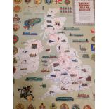

Two John Bartholomew and Son railway history maps of Britain
Lot 121
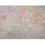
A late 19th century map of Edinburgh south division taken from an electrotype taken in 1885. 100cm
A late 19th century map of Edinburgh south division taken from an electrotype taken in 1885. 100cm in width by 70cm in height
Lot 122
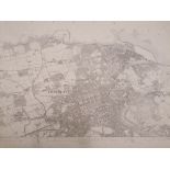
A late 19th century map of Edinburgh by John Bartholomew and Co, Edinburgh. 95cm in width by 70cm in
A late 19th century map of Edinburgh by John Bartholomew and Co, Edinburgh. 95cm in width by 70cm in height
![Map of Scotland [ORTELIUS(ABRAHAM)] Scotia Tabula, a framed double-page hand coloured engraved](https://portal-images.azureedge.net/auctions-2020/donald10000/images/5a7de808-74e0-46f5-9847-ac6101109693.jpg?w=155&h=155)
Lot 124
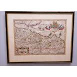
Map of Scotland [ORTELIUS(ABRAHAM)] Scotia Tabula, a framed double-page hand coloured engraved
Map of Scotland [ORTELIUS(ABRAHAM)] Scotia Tabula, a framed double-page hand coloured engraved map, of Scotland c1600 Oriented to the west. 48cm i...
Lot 125
An early 17th century Map of Lothian with A New Descirption Of The Shyres Lothian And Linlithgow. By
An early 17th century Map of Lothian with A New Descirption Of The Shyres Lothian And Linlithgow. By T. Pont. Judocus Hondius calavit Sumptibus, A...