Refine your search
Sale Section
Estimate
Category
Creator / Brand
- Mercator (5)
- Robert Sayer (4)
- Blaeu (3)
- Edward Stanford (3)
- George Philip and Son (3)
- John Bowles and Son (3)
- Chaucer (2)
- Depot Generale de la Marine (2)
- Jane Austen (2)
- John Bartholomew (2)
- John Tallis (2)
- Agatha Christie (1)
- Black & White (1)
- Charles Price (1)
- Denis Diderot (1)
- Edward Weller (1)
- Evelyn Waugh (1)
- Francis Bacon (1)
- French School (1)
- George Morland (1)
- Deutsch (1)
- Giovanni Battista Piranesi (1)
- Goethe (1)
- Ian Mcewan (1)
- J H Colton (1)
- Jacques Nicholas Bellin (1)
- James Imray (1)
- James Imray and Son (1)
- John Cary (1)
- John Franklin (1)
- John Senex (1)
- Laurence Sterne (1)
- Le Rouge (1)
- Leslie George Bullock (1)
- Lewis Carroll (1)
- London Magazine (1)
- Muriel Spark (1)
- Mynde (1)
- Ortelius (1)
- Rigobert Bonne (1)
- Roald Dahl (1)
- Robert Wilkinson (1)
- Rudyard Kipling (1)
- Second World War (1)
- The Corporation of Trinity House (1)
- Thomas Kitchin (1)
- Vogue (1)
- Vogue Magazine (1)
- W Rose (1)
- William Faden (1)
- William Hogarth (1)
- William Shakespeare (1)
- Royal Copenhagen (1)
Item Type
- Book (102)
- Folio (81)
- Map (76)
- Letter (58)
- Manuscript (38)
- Lithograph (32)
- Engraving (28)
- Bible (13)
- Atlas (12)
- Portrait (10)
- Journal (9)
- Road map (6)
- Dictionary (5)
- Etching (5)
- Famous Author (5)
- Road map (4)
- 15th-18th Century Art (3)
- Magazine (3)
- Militaria (3)
- Oleograph (3)
- Ordnance survey map (3)
- Cartographers and Mapmakers (2)
- Celestial Chart (2)
- Knives and Blades (2)
- Manual (2)
- Manuscripts (2)
- Military Uniform (2)
- Sword (2)
- Uniform (2)
- 19th-21st Century Art (1)
- Advertising (1)
- Antique Arms (1)
- Badges, Medals & Pins (1)
- Bordeaux (1)
- C5 (1)
- Dictionaries (1)
- Folios (1)
- French Wine (1)
- Globe (1)
- Heliogravure (1)
- Magazines (1)
- Medal (1)
- Military Medal (1)
- Modern & Impressionist Art (1)
- Oil painting (1)
- Periodical (1)
- Planisphere (1)
- Poetry (1)
- Porcelain (1)
- Portrait Painting (1)
- Rifle (1)
- Treen (1)
- WW2 Militaria (1)
- Wine (1)
- Woodblock (1)
- List
- Grid
A subscription to the Price Guide is required to view results for auctions ten days or older. Click here for more information
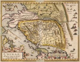

China. Ortelius (Abraham), Chinae olim Sinarum regionis nova descriptio..., Antwerp [1592 or
* China. Ortelius (Abraham), Chinae olim Sinarum regionis nova descriptio, auctore Ludovico Georgio, Antwerp [1592 or later], hand-coloured engrav...
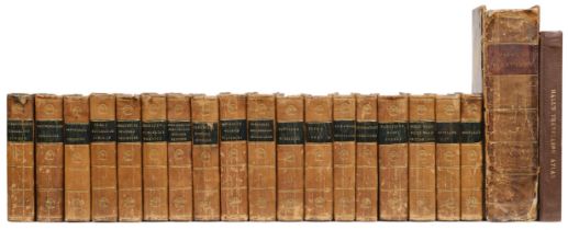
Cooke (C.). Topographical and Statistical Description of the County of..., 18 volumes, circa 1830
Cooke (C.). Topographical and Statistical Description of the County of..., 18 volumes, circa 1830, additional title to volume 13, 'The Modern Brit...
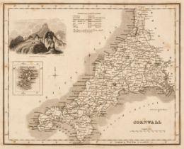
![Cornwall. Kip (William), Cornwall olim pars Danmoniorum [1610]](https://portal-images.azureedge.net/auctions-2024/srdom10237/images/2a6a8956-10ac-4f68-8388-b16200a8bea5.jpg?h=210)
Cornwall. Kip (William), Cornwall olim pars Danmoniorum [1610], hand-coloured engraved map, large inset vignette of Launceston, narrow vertical ma...
D'Anville (Jean Baptiste). Atlas with 30 engraved maps, circa 1714-64, lacking title, 30 engraved maps (mostly 2 sheet, 4 folding), the majority w...
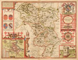
Derbyshire. Speed (John), Anno Darbieshire described, J. Sudbury & George Humble, circa 1627
Derbyshire. Speed (John), Anno Darbieshire described, J. Sudbury & George Humble, circa 1627, hand-coloured engraved map, inset town plan of Derby...
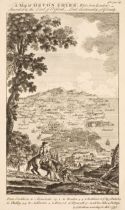
Devon. Bickham (G.), A Map of Devon - Shire West from London..., 1750, uncoloured 'birds-eye' map with text above and below the image, 260 x 160 m...
Devon. Bowen (Emanuel), An Accurate Map of Devon Shire, Divided into its Hundreds, Drawn from the best Authorities..., John Bowles & Sons, Messrs ...
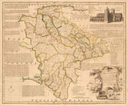
Devon. Greenwood (C. & J.), Map of the County of Devon from an Actual Survey, made in the Years 1825 & 1826 by C. & J. Greenwood, most Respectfull...
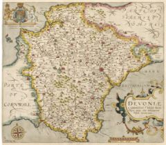
Devon. Saxton (Christopher & Kip Wlliam), Devoniae Comitatus vulgo Denshyre quam olim Danmonii Populi Incolouerunt, [1637], hand-coloured engraved...
![East Indies. Jansson (Jan), Indiae Orientalis Nova Descriptio, [1635 or later]](https://portal-images.azureedge.net/auctions-2024/srdom10237/images/a7ee968f-9ad8-47c1-9880-b16200a8c1e6.jpg?h=210)
* East Indies. Jansson (Jan), Indiae Orientalis Nova Descriptio, Amsterdam [1635 or later], hand-coloured engraved map, decorative cartouche and m...
England & Europe. A collection of approximately 80 maps, mostly 19th & 20th-century, engraved maps, road maps, siege maps, town plans, pedigrees a...
![England and Wales. Geological Map of England & Wales. London: Dobbs & Co., [1843]](https://portal-images.azureedge.net/auctions-2024/srdom10237/images/b42395df-0b6a-4c20-a618-b16200a8c2bf.jpg?h=210)
England and Wales. Dobbs & Co.'s Relievo Maps, Drawn & Engraved from the Highest Official Authorities. Geological Map of England & Wales. Arranged...
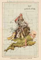
England and Wales. Merry (Tom, pseud William Mecham), Map of England, A Modern St. George and the Dragon!!!, St. Stephen's Review, 1888, colour li...
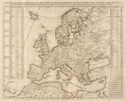
Europe. Bohn (F.), Europa Volgens de Nieuwste Verdeeling, Haarlem, circa 1794, engraved allegorical map with contemporary wash colouring, old fold...
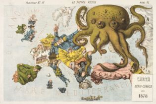
Europe. Grossi (Augusto), La Piovra Russa, published Papagallo - Le Perroquet Magazine, 1878
Europe. Grossi (Augusto), La Piovra Russa, Carta Serio-Comica, published Bologna, Papagallo - Le Perroquet Magazine, 14th April 1878, an allegoric...
Folding maps. A collection of 10 folding maps of towns/ boundaries in England, mostly 19th-century
Folding maps. A collection of 10 folding maps of towns/boundaries in England, mostly 19th century, including Mogg (William publisher). Map of the ...
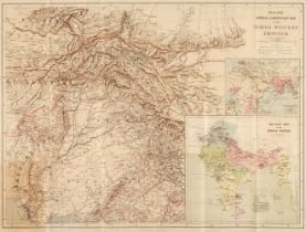
Folding maps. A collection of 6 folding maps of foreign parts, mostly 19th-century, including Philips's Special Large Scale Map of the North Weste...
Foreign Maps. A collection of approximately 70 maps, mostly 19th & 20th-century, engraved maps, views, pedigrees and others, mostly uncoloured, in...
Fullarton (A. Publisher). The Parliamentary Gazetteer of England and Wales, 4 volumes, London, Edinburgh, and Dublin, 1845, 40 uncoloured engraved...
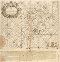
Greenville Collins (Captain). Great Britain's Coasting Pilot..., J. & W. Mount & T. Page, 1779
Greenville Collins (Captain). Great Britain's Coasting Pilot, Being a new and Exact Survey of the Sea-Coast of England and Scotland, from the Rive...
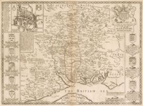
Hampshire. Speed (John), Hantshire described and devided, Thomas Bassett & Richard Chiswell, 1676
* Hampshire. Speed (John), Hantshire described and devided, Thomas Bassett & Richard Chiswell [1676], uncoloured engraved map, inset town plan of ...
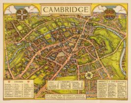
Hoffman (George Spenser). No.1 (Cambridge) and No.3 (Canterbury) of Phillips 'Wayabout' series by Spencer Hoffman, London: George Phillip & Son Lt...
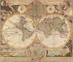
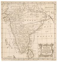
* Homann (Johann Baptiste). Planiglobii Terrestris Cum Utroq Hemisphaerio Caelesti Generalis Exhibitio..., Nuremberg, circa 1715, hand-coloured en...
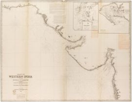
India. Ghose (R. S.), Sketch map of River Hooghly from Hooghly to Ulabaria, Showing Jute and Cotton Mills, Factories, Presses and Port Commissione...
![Ireland. Van Loon (H.), Carte Generale des Costes D'Irlande..., [1661 or later]](https://portal-images.azureedge.net/auctions-2024/srdom10237/images/ad6f2392-25ec-444a-9fc1-b16200a8c8db.jpg?h=210)
Ireland. Van Loon (Hermanus.), Carte Generale des Costes D'Irlande et des Costes Occidentales D'Angleterre avec une Partie de celles D'Ecosse, [16...
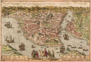
* Istanbul. Braun (Georg & Hogenberg Franz), Byzantium Nunc Constantinopolis, Cologne, circa 1580, engraved map with contemporary hand-colouring, ...
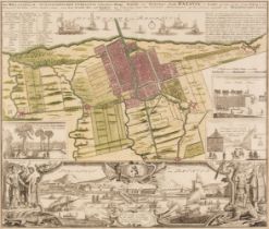
* Jakarta. Homann (Johann Baptist, heirs of), Der Hollaendisch - Ostindianischen Compagnie Weltberühmte Haupt-Handels Niederlags - Stadt Batavia i...
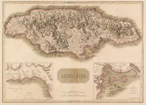
Jamaica. Thomson (John), Jamaica, circa 1817, double-page map engraved by T. Clerk with contemporary outline colouring, inset maps of the Harbours...
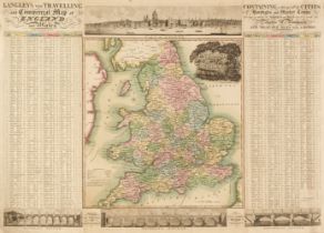
Langley (Edward & Belch William). Langley's new travelling and commercial map of England..., 1817
Langley (Edward & Belch William). Langley's New Travelling and Commercial Map of England and Wales. Containing a list of all the Cities, Boroughs ...
Laurie (Robert & Whittle, James). Laurie and Whittle's New Traveller's Companion, Exhibiting a Complete and Correct Survey of all the Direct and P...
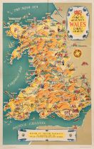
Lee (Kerry). Come to Beautiful Wales, Cymru am Byth, Railway Executive (publisher), circa 1953
Lee (Kerry). Come to Beautiful Wales, Cymru am Byth, Railway Executive - London Midland Region - (publisher), printed by McCorquodale & Co. Ltd, c...
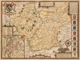
* Leicestershire. Speed (John), Leicester both countye and Citie described, The Honorable famylies that have had the titles of Earls thereof. With...
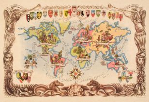
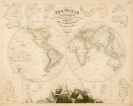
Liozu (Jacques). Eight Pictorial Maps, Untitled Map of the World (on Mercator's projection), Europe Occidentale, Amérique du Sud, Amérique du Nord...
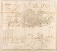
Liverpool. George Phillips' Plan of Liverpool and the Surrounding Cheshire Coast, Compiled from Actual Surveys, circa 1880, uncoloured folding lit...
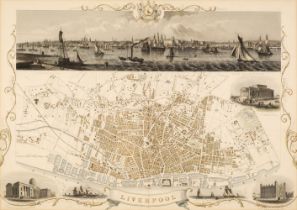
* Liverpool. Rapkin (J.), Liverpool, John Tallis & Company, circa 1850, hand-coloured engraved double-page city plan, inset vignettes, large panor...
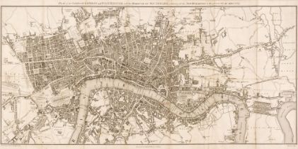
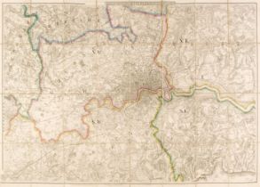
London. A collection of approximately 140 maps and prints, mostly 19th & 20th-century, engraved maps, views, plans and road maps of London, London...
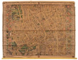
London. Gill (Leslie MacDonald), Pictorial Map of Central London, Waterlow and Sons Ltd. 1932, large chromolithographic map with lines of verse to...
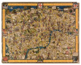
London. Gill (MacDonald). Wonderground Map of London Town, The Westminster Press, circa 1928
London. Gill (MacDonald). Wonderground Map of London Town, The Westminster Press, circa 1924, photolithographic colour printed map, long closed te...
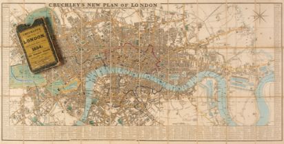
London. Cruchley (George Frederick), Cruchley's New Plan of London Shewing all the New and Intended Improvements to the Present Time, 1834, engrav...
Map Reference. A collection of approximately 40 books, mostly 20th-century, including Shirley (Rodney. W.). The Mapping of the World, Holland Pres...
Maps. A collection of 13 maps, 17th - 19th century, engraved and lithographic British county and foreign maps, including examples by or after Matt...
Maps. A collection of approximately 200 maps, 18th & 19th century, engraved and lithographic British and foreign maps, including examples by or af...
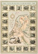
Meyer (Frans). 1940 Nederland in Oorlogstijd 1945, published Stichting, Amsterdam, circa 1947
Meyer (Frans). 1940 Nederland in Oorlogstijd 1945, published Stichting 1940 - 1945, Amsterdam, circa 1947, Dutch lithographic pictorial map showin...
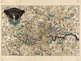
Miller (Linden). Charrington's Map and Guide to London Football Grounds, 1930 - 1931, colour lithographic pictorial map, old folds, list of all th...
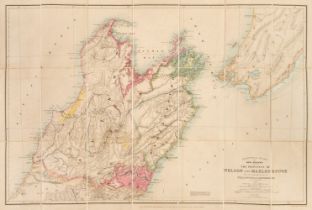
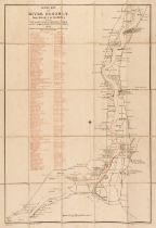
New Zealand. Stanford's Atlas of New Zealand, the Provinces of Nelson and Malbrough with the adjacent parts of Wellington and Canterbury..., Londo...
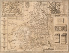
* Northumberland. Speed (John), Northumberland, John Sudbury & George Humble [1611 or later], uncoloured engraved map, inset town plans of Berwick...
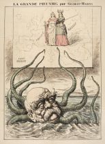
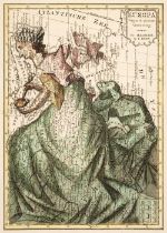
Otto von Bismarck. Gilbert-Martin (Charles), La Grande Pieuvre, published in 'Le Don Quichotte' Magazine, 1888, coloured wood engraved map depicti...
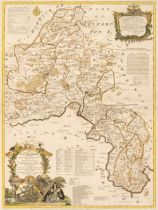
* Oxfordshire. Kitchin (Thomas). A New Improved Map of Oxfordshire from the best Surveys and Intelligences, Divided into its Hundreds..., Caringto...

* Pembroke. Speed (John), Penbrokshyre described and the Sittuations both of Pembroke and St Davids shewed in due form as they were taken..., John...
Pictorial maps. 20 colour lithograph pictorial maps by Jylbert, France: 1943, including Corsica, Provence, Tunisia, Madagascar, Tahiti, Morocco, R...
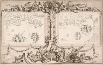
Pine (John). Two sea charts (on one sheet) originally published in 'The Tapestry Hangings of the House of Lords, Representing the Several Engageme...
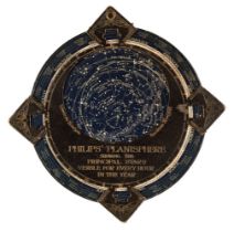
Planisphere. Philips' Planisphere showing the Principal Stars Visible for every Hour in the Year, circa 1890, celestial chart of the stars, printe...
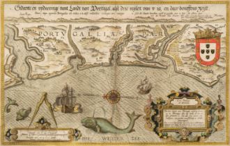
* Portugal. (Waghenaer (Lucas Janszoon), Die Zee Caerte van Portugal, tusschen Camino en Montego, alsoe dat Landt Alt daer in sijn Ghedaente is, m...
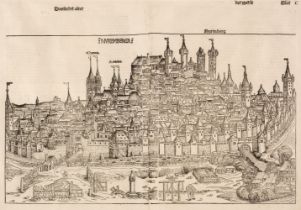
* Schedel (Hartmann). Nuremberga, published Nuremberg, circa 1493, uncoloured woodcut view on two conjoined sheets, large margins, 390 x 560 mm, m...
Sea Charts. A collection of 11 large blue-backed engraved charts, published by James Imray & Sons, Laurie and Norrie & Wilson, mid 19th and early ...
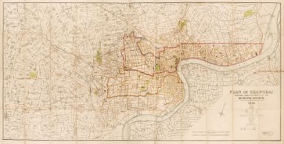
Shanghai. Stanfords (publisher), Plan of Shanghai, published under Authority of the Municipal Council, 1928, colour printed lithographic map, sect...
Shaw (Norton). The Royal Illustrated Atlas of Modern Geography... [London and Edinburgh: A. Fullerton and Co, 1862], 74 hand-coloured engraved map...
![South Africa. Boyle (Stuart), A Map of the Cape Peninsula..., [1952]](https://portal-images.azureedge.net/auctions-2024/srdom10237/images/012c368c-b898-416d-8d3f-b16200a8d852.jpg?h=210)
South Africa. Boyle (Stuart), A Map of the Cape Peninsula Issued by The Cape Peninsula Publicity Association, Adderley Street Cape Town, South Afr...
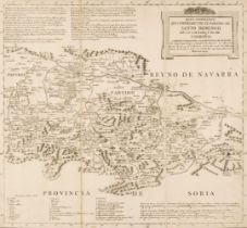
Spain and Portugal. Lopez (Thomas). Mapa de la Provincia de Extramadura..., Madrid, 1798 and others
Spain and Portugal. Lopez (Thomas). Mapa de la Provincia de Extramadura..., Madrid, 1798, engraved map sectionalised and laid on linen on 4 sheets...
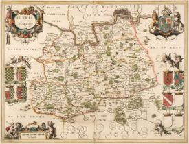
* Surrey. Jansson (Jan), Surria vernacule Surrey, Amsterdam, circa 1650, engraved map with bright contemporary outline colouring, decorative carto...