Filtered by:
- Sale Section,
- Item Type
- List
- Grid
A subscription to the Price Guide is required to view results for auctions ten days or older. Click here for more information

Aitchison (Alexander). The Modern Gazetteer; being a compendious geographical dictionary... 2 volumes, London: R. Morison & Son, 1798, 15 folding ...
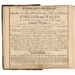
Badeslade (Thomas & William Henry Toms). Chorographia Britanniae. or A New Set of Maps of all the Counties in England and Wales, London, circa 174...
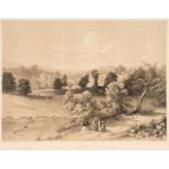
Burkill, (John). Bolton Illustrated: A Series of Views of the Scenery around Bolton Abbey..., 1848
Burkill, (John). Bolton Illustrated: A Series of Views of the Scenery around Bolton Abbey, Wharfdale, Yorkshire, the picturesque domain of His Gra...

Camden (William). Britannia: or, a chorographical description of the flourishing kingdoms of England, Scotland, and Ireland; and the islands adjac...
Hoare (Richard Colt). A Collection of Forty-Eight Views of Noblemen's and Gentlemen's Seats, Towns, Castles, Churches, Monasteries, and Romantic P...
Lewis (William), Lewis's New Traveller's Guide, and Panorama of England and Wales. Containing Forty-Four Superior Maps, with all the direct and cr...

Loch (David). Essay on the trade, commerce, and manufacture of Scotland, 1st edition, 1775..., and
Loch (David). Essay on the Trade, Commerce, and Manufacture of Scotland, 1st edition, Edinburgh: Printed for the Author, 1775, vii,92pp., minor lo...
Moule (Thomas). An untitled part atlas, circa 1837, containing 30 uncoloured engraved maps by Thomas Moule including six folding (Suffolk, Norfol...
Nattes (John Claude). Bath, Illustrated by a Series of Views... with descriptions to each plate, London & Bristol: William Miller & William Sheppa...
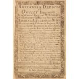
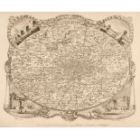
Owen (John & Bowen Emanuel). Britannia Depicta or Ogilby Improv'd; being a Correct Coppy of Mr Ogilby's Actual Survey of all ye Direct & Principal...
![Richardson (Thomas Miles). Memorials of old Newcastle upon Tyne, [1880]](https://portal-images.azureedge.net/auctions-2022/srdom10207/images/0746d010-3c3d-4504-9456-af5f011d9b67.jpg?w=155&h=155)
Richardson (Thomas Miles). Memorials of old Newcastle upon Tyne ... comprising forty etchings from original drawings of the towers, gateways, chur...

Robertson (Archibald). A Topographical Survey of the Great Road from London to Bath and Bristol. With historical and descriptive accounts of the c...
Smith (John Thomas). Ancient Topography of London; containing not only views of buildings, which in many instances no longer exist, and for the mo...
Swarbreck (Samuel). Sketches in Scotland, C. Hullmandel, 1839, decorative lithographic title, dedication, list and explanation, 24 (complete) lith...
![Wallis (James). Wallis's New Pocket edition of the English Counties... [1810]](https://portal-images.azureedge.net/auctions-2022/srdom10207/images/e825b790-209c-4553-b580-af5f011d9da2.jpg?w=155&h=155)
Wallis (James). Wallis's New Pocket Edition of the English Counties or Travellers Companion in which are carefully laid down all the Direct & Cros...
![Wallis (James, printer). The Panorama: or Traveller's Instructive Guide..., W. H. Reid [1820]](https://portal-images.azureedge.net/auctions-2022/srdom10207/images/374e0f65-3698-48d5-84e2-af5f011d9e71.jpg?w=155&h=155)
Wallis (James, printer). The Panorama: or Traveller's Instructive Guide..., W. H. Reid [1820]
Wallis (James, printer). The Panorama: or Traveller's Instructive Guide; through England and Wales; Exhibiting all the Direct and Principal Cross ...