Filtered by:
- Sale Section,
- Category
- List
- Grid
A subscription to the Price Guide is required to view results for auctions ten days or older. Click here for more information

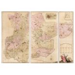
Stackhouse (Thomas). An Universal Atlas Consisting of a Complete Set of Maps, to Illustrate Ancient and Modern Geography..., 6th edition Revised a...
Hoare (Richard Colt). A Collection of Forty-Eight Views of Noblemen's and Gentlemen's Seats, Towns, Castles, Churches, Monasteries, and Romantic P...
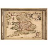
Lewis (William), Lewis's New Traveller's Guide, and Panorama of England and Wales. Containing Forty-Four Superior Maps, with all the direct and cr...
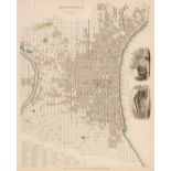
Moule (Thomas). An untitled part atlas, circa 1837, containing 30 uncoloured engraved maps by Thomas Moule including six folding (Suffolk, Norfol...
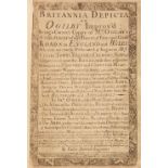
Owen (John & Bowen Emanuel). Britannia Depicta or Ogilby Improv'd; being a Correct Coppy of Mr Ogilby's Actual Survey of all ye Direct & Principal...
![Wallis (James). Wallis's New Pocket edition of the English Counties... [1810]](https://portal-images.azureedge.net/auctions-2022/srdom10207/images/e825b790-209c-4553-b580-af5f011d9da2.jpg?w=155&h=155)
Wallis (James). Wallis's New Pocket Edition of the English Counties or Travellers Companion in which are carefully laid down all the Direct & Cros...
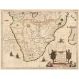
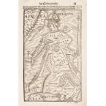
Africa. Blaeu (Willem Janszoon), Aethiopia Inferior vel Exterior..., circa 1645, engraved map of South Africa with contemporary outline colouring,...
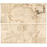
Africa. Sayer (Robert, publisher), Africa according to the Sieur D'Anville Illustrated with a Summary Description Relative to its Trade and Natura...
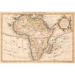
Africa. Six maps, 18th & 19th century, engraved maps, five of the continent with examples by or after Bell, Findlay, Baker, Rollos and Jeffries, v...
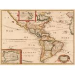
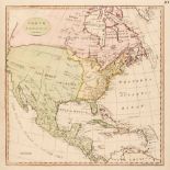
* Americas. Bertius (Petrus), Carte de l'Amerique Corrigée, et augmentée dessus toutes les aultres cy devant: faites P. Bertius, 1639, hand colour...
* Anglesey. Speed (John), Anglesey Antiently called Mona, John Sudbury & George Humble, 1627, hand-coloured engraved map, inset town plan of Beaum...
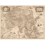
* Asia. Blaeu (Willem Janszoon), Asia noviter delineata, Amsterdam, circa 1633, hand-coloured engraved map, vertical margins trimmed with slight l...
Asia. Hondius (Henricus), Asia Recens Summa Cura Delineata, Jan Jansson, Amsterdam, circa 1641, uncoloured engraved map, ornamental strapwork titl...
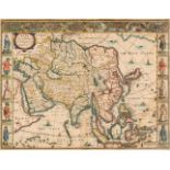
Asia. Speed (John), Asia with the Ilands adjoyning described, the atire of the people & townes of importance, all of them newly augmented by J. S....
Australia. Arrowsmith (J.), Part of the North Coast of Australia shewing the situation of Port Essington. Compiled from Official Documents, James ...
Basire (James). A collection of 24 prospects of fortified towns and battle plans, originally published in Rapin de Thoyras's 'History of England',...
* Blaeu (Willem Janszoon). Aethiopia Superior vel Interior vulgo Abissinorum sive Presbiteri Joannis Imperium, Amsterdam, circa 1660, engraved map...
![Bohemia. Speed (John), Bohemia Newly Described, Thomas Bassett & Richard Chiswell [1676]](https://portal-images.azureedge.net/auctions-2022/srdom10207/images/55b15c00-eec5-4215-b5fa-af5f011dafd1.jpg?w=155&h=155)
Bohemia. Speed (John), Bohemia Newly Described, Thomas Bassett & Richard Chiswell [1676], uncoloured engraved 'carte-a figure' map, ten costume vi...
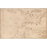
Bristol Channel. Norie (J. W.), A New Chart of Bristol Channel Shewing the Navigation from Padstow Harbour and Milford Haven to Kings Road, Drawn ...
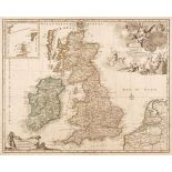
British Isles. A collection of 38 maps, 17th - 19th century, engraved maps of the British Isles and England & Wales, including examples by or afte...
![British Isles. Bordone (Benedetto), Inghilterra secondo Tolemeo, Venice [1528 - 34],](https://portal-images.azureedge.net/auctions-2022/srdom10207/images/ffb81f9e-6c8a-4b83-896f-af5f011db25d.jpg?w=155&h=155)
British Isles. Bordone (Benedetto), Inghilterra secondo Tolemeo [printed on map], Venice [1528 -34], uncoloured woodblock map in the Ptolemaic man...
British Isles. Elwe (Ian), Les Isles Britannique qui contiennent les Royaumes d'Angleterre, Ecosse et Irlande..., Amsterdam, 1792, engraved map wi...
British Isles. Hondius (H. Mercator Gerard & Purchas Samuel), Anglia, Scotia et Hibernia, 1625
British Isles. Hondius (H. Mercator Gerard & Purchas Samuel), Anglia, Scotia et Hibernia [and] Anglia [1625], two hand-coloured engraved maps, eac...
![British Isles. Honter (Johannes), Atlantici Maris ora et Insulae, Basle [1576]](https://portal-images.azureedge.net/auctions-2022/srdom10207/images/bc549d63-a358-45d9-8013-af5f011db4d1.jpg?w=155&h=155)
British Isles. Honter (Johannes), Atlantici Maris ora et Insulae, Basle [1576], uncoloured Ptolemaic map on a trapezoidal projection, initially pu...
British Isles. Jansson (Jan & Ortelius Abraham), Insularum Britannicarum Acurata..., circa 1646
British Isles. Jansson (Jan & Ortelius Abraham), Insularum Britannicarum Acurata Delineatio ex Geographicis Conatibus Abrahami Ortelii, Amsterdam,...
* British Isles. Ortelius (Abraham), Britannicarum Insularum Typus, [1595 or later], engraved map with contemporary outline colouring, orientated ...

British Isles. Pine (John), A Chart shewing the several Places of Action between the English and Spanish Fleets, with the Places where several of ...
![British Isles. Quad (Matthias), Angliae regni florentisimi nova descriptio..., [1600]](https://portal-images.azureedge.net/auctions-2022/srdom10207/images/34852983-9588-4118-b808-af5f011db81f.jpg?w=155&h=155)
British Isles. Quad (Matthias), Angliae regni florentisimi nova descriptio auctore Humeredo Lhuyd Denbygiense, [1600], uncoloured engraved map, sl...
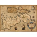
British Isles. Speed (John), Britain as it was devided in the tyme of the English Saxons..., 1676
* British Isles. Speed (John), Britain as it was devided in the tyme of the English Saxons especially during their Heptarchy, Thomas Bassett & Ric...
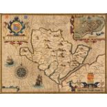
![Buckinghamshire. Speed (John), Buckingham both Shyre and Shire towne described, [1616]](https://portal-images.azureedge.net/auctions-2022/srdom10207/images/7c8d79b4-f2c6-4fb5-b2df-af5f011db9be.jpg?w=155&h=155)
* Buckinghamshire. Speed (John), Buckingham both Shyre and Shire towne describ. George Humble [1616], hand-coloured engraved map, inset town plans...
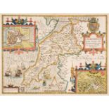
Caernarvonshire. Speed (John), Caernarvon Both Shyre and Shire-towne with the ancient Citie Bangor Described, Thomas Bassett & Richard Chiswell [1...
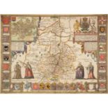
* Cambridgeshire. Speed (John), Cambridgeshire described with the Devision of the Hundreds, the Townes situation with the Armes of the Colleges of...
Cary (John). A collection of 32 maps, J. Stockdale, circa 1805, uncoloured engraved maps, old folds, occasional duplicates, each approximately 500...
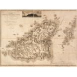
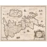
Channel Islands. Gray (Andrew), A Topographical Map of the Islands of Guernsey, Sark..., 1816
Channel Islands. Gray (Andrew), A Topographical Map of the Islands of Guernsey, Sark, Herm & Jethou, likewise all the adjacent Rocks, Shoals and P...
![Chatelain (Henry Abraham). Seven maps relating to the British Isles [circa 1708]](https://portal-images.azureedge.net/auctions-2022/srdom10207/images/d6566903-6e61-4515-b12b-af5f011dbe0c.jpg?w=155&h=155)
Chatelain (Henry Abraham). Seven maps relating to the British Isles, Nouvelle Carte D'Angleterre et D'Irlande avec les Instructions pour Connoitr...
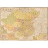
China. Jih - Sin Geographical Institute (publisher), New China Map, 1938, colour printed lithographic map laid on linen, old folds, some creasing ...
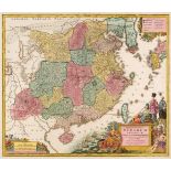
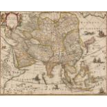
China. Lotter (Tobias Conrad), Opulentissimum Sinarum Imperium juxta Recentissimam Delineationem in suas Provincias Disterminatum Cura et Sumtibus...
![China. Speed (John), The Kingdome of China, George Humble, [1627]](https://portal-images.azureedge.net/auctions-2022/srdom10207/images/94684579-05f3-4c78-89ab-af5f011dc319.jpg?w=155&h=155)
China. Speed (John), The Kingdome of China, George Humble, [1627], hand-coloured 'carte-a-figure' map, with eight costumed figures to the vertical...
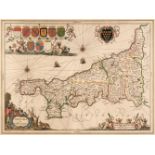
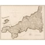
* Cornwall. Jansson (Jan), Cornubia sive Cornwallia, Amsterdam, circa 1646, engraved map with contemporary outline colouring, 380 x 510 mm, mounte...
![Cornwall. Speed (John), Cornwall, Thomas Bassett & Richard Chiswell [1676]](https://portal-images.azureedge.net/auctions-2022/srdom10207/images/82db9b1f-15e2-4f10-a51f-af5f011dc4b8.jpg?w=155&h=155)
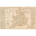
* Cornwall. Speed (John & Norden John), Cornwall, Thomas Bassett & Richard Chiswell [1676], uncoloured engraved map, inset view of Launceston, lar...
England & Wales. A collection of 30 maps, 17th - 19th century, engraved and lithographic maps of England and Wales and the British Isles, with exa...
England & Wales. A collection of 34 maps, 18th & 19th century, engraved and lithographic maps of the British Isles and England and Wales, includin...
England & Wales. Moll (Herman), The South Part of Great Britain Called England and Wales, 1730
England & Wales. Moll (Herman), The South Part of Great Britain Called England and Wales..., J & T Bowles, P. Overton and J. King [1730], engraved...
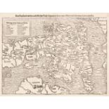
England & Wales. Munster (Sebastian), Das Engelland mit dem Anstossenden Reich Schottland so vor zeiten Albion und Britannia haben geheissen, Basl...
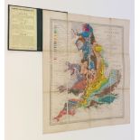
England & Wales. Murchison (Sir Roderick), Geological Map of England and Wales, 5th edition, Edward Stanford, 1864, map with bright contemporary h...
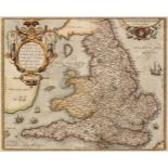
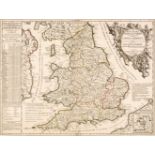
* England & Wales. Ortelius (Abraham), Angliae Regni Florentissimi nova descriptio auctore Humfredo Lhuyd Denbygiense, Antwerp [1592 - 1601], hand...
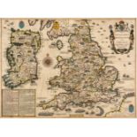
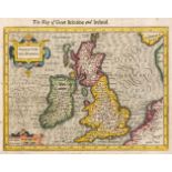
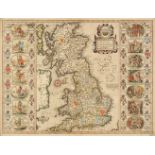
* England, Wales & Ireland. Speed (John), The Invasions of England and Ireland with al their Civill Wars since the Conquest, George Humble, circa ...
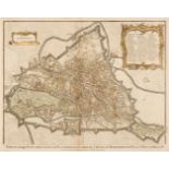
Essex. Essex. Chapman J. & Andre P.), A map of the County of Essex, from an actual Survey..., 1785
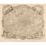
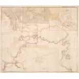
Essex. Chapman (John, and André, Peter). A Map of the County of Essex from an actual survey taken in MDCCLXXII: LXXIII & MDCCLXXIV by John Chapman...
Europe. Munster (Sebastian), Allegorical Map of Europe, Basel, circa 1598, uncoloured allegorical woodblock map of Europe, slight marginal water a...
![Europe. Ortelius (Abraham), Romani Imperii Imago, [1579 or later]](https://portal-images.azureedge.net/auctions-2022/srdom10207/images/382cc9c3-93e0-4460-bea6-af5f011dcc80.jpg?w=155&h=155)
* Europe. Ortelius (Abraham), Romani Imperii Imago, [1579 or later], hand-coloured engraved map, inset genealogical tree of Roman kings, strapwork...
![Europe. Speed (John), A New Mappe of the Romane Empire..., George Humble [1627]](https://portal-images.azureedge.net/auctions-2022/srdom10207/images/3c49bd55-545e-417b-acc3-af5f011dcd3e.jpg?w=155&h=155)
Europe. Speed (John), A New Mappe of the Romane Empire..., George Humble [1627], uncoloured engraved 'carte-a-figure' map, ten costumed figures to...
Folding Maps. A collection of 12 maps, 19th & early 20th century, engraved and lithographic folding maps of British and European counties, regions...
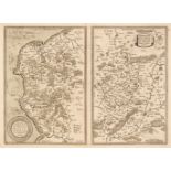
Folding Maps. A Collection of six maps, mostly 19th-century, including Kirkwood (Robert). Map of Scotland constructed and engraved from the best a...
Foreign Maps. A collection of 23 maps, mostly 19th century, engraved country maps and city plans, including examples by or after S. D. U. K. Rapki...
France. A collection of 25 maps, mostly 17th & 18th century, regional maps and town plans, including examples by or after Ortelius, Bellin, Bowen,...
![France. De Jode (Gerard), Galliae Amplissimi Regni Tabula [1593]](https://portal-images.azureedge.net/auctions-2022/srdom10207/images/9f0668f9-e548-414a-81fa-af5f011dd106.jpg?w=155&h=155)
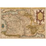
* France. De Jode (Gerard), Galliae Amplissimi Regni Tabula [1593], engraved map with contemporary hand-colouring, large floriate cartouche and mi...
* France. Ortelius (Abraham), Galliae Regni Potentiss: Nova Descriptio Ioanne Ioliveto [1570 or later], engraved map with contemporary hand-colour...
Germany. A collection of 16 maps, mostly 17th & 18th century, regional maps, including examples by Homann, Ortelius, Le Rouge, Moll and De Fer, va...
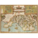
Glamorgan. Speed (John), Glamorgan Shyre, with the situations of the Cheife Towne Cardyff, 1662
* Glamorgan. Speed (John), Glamorgan Shyre, with the situations of the Cheife Towne Cardyff and ancient Landaffe described, Roger Rea [1662], hand...
Grante (J. A.). Carte ou sont tracees les differences routes..., Charles Edward Prince de Galles...,
Grante (James Alexander). Carte où sont tracées les différentes routes que S.A.R. Charles Edward Prince de Galles, a suivies dans la Grande Bretag...