Filtered by:
- Sale Section
- List
- Grid
A subscription to the Price Guide is required to view results for auctions ten days or older. Click here for more information
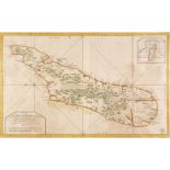

Madagascar. Bellin (Jacques Nicolas), Carte de l'Isle de Madagascar dressée au Depost des Cartes, Plans et Journaux de la Marine..., Depot de la M...
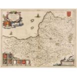
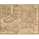
Manchester. Laurent (C. surveyor), A Topographical Plan of Manchester and Salford, with the Adjacent Parts shewing also the Different Allotments o...
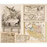
Maps. A mixed collection of approximately 175 maps, mostly 18th & 19th century, engraved and lithographic maps, battle plans and charts of foreign...
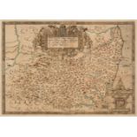
Middlesex & Hertfordshire. Jansson (Jan), Middelsexiae cum Hertfordiae comitatu Midlesex & Hertford Shire, Amsterdam, circa 1650, engraved map wit...
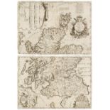
![Morden (Robert). A collection of 30 county maps [1695 or later]](https://portal-images.azureedge.net/auctions-2021/srdom10181/images/93591b61-ba64-4d18-a046-adc900f674b7.jpg?w=155&h=155)
Morden (Robert). A collection of 30 county maps [1695 or later], engraved maps, 29 with later hand-colouring, occasional duplicates, slight spotti...
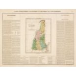
North America. Buchon (Jean Alexandre), A collection of eight maps of North American States, Carte Géographique, Statistique et Historique du..., ...
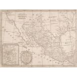
North America. Kitchin (Thomas), Mexico or New Spain in which the Motions of Cortes may be Traced..., W. Strahan & T. Cadell, 1793, uncoloured eng...
Northern Europe. Ruscelli (Giralomo), Tabula Europae IIII, 1561 - 74, hand-coloured engraved map on a trapezoidal projection, slight text show thr...
Pine (John). Two untitled charts showing the progress of the Spanish Armada (nos. 3 & 4), 1739
Pine (John). Two untitled charts showing the progress of the Spanish Armada (nos. 3 & 4), 1739, two hand-coloured charts on one sheet (as publishe...
Poland. A collection of nine maps, mostly 18th century, engraved maps, six with hand-colouring, including examples by Nilson, Gibson, Bowen/Meijer...
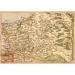
Poland. A collection of ten maps, 16th - 18th century, engraved maps, five with hand-colouring, including examples by Hogenberg, Botero, Munster, ...
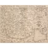
Poland. Munster (Sebastian), Polonia et Ungaria XV Nova Tabula, circa 1550, uncoloured woodblock map of Poland, Lithuania, Moscovy and the Balkans...
Prussia. Sotzmann (Daniel F.), Topographische Militarische Karte Nee Ostpreussen der dem jetzigen Nördlichen Theil des Herzogthums Warschau nebst ...
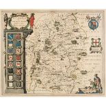
Saxton (Christopher & Hole G. & Kip W.). A collection of 13 maps, [1607 - 37], hand-coloured engraved maps, each approximately 260 x 305 mm, one m...
Scandinavia. Ruscelli (Girolamo), Schonladia Nuova, Venice, 1598, uncoloured engraved map on a trapezoidal projection, slight staining to the marg...
Scotland. Coronelli (V. M.), Scotia Parte Settentrionale & Scotia Parte Meridionale, circa 1700
Scotland. Coronelli (Vincenzo Maria), Scotia Parte Settentrionale..., & Scotia Parte Meridionale..., Venice, circa 1700, two sheet uncoloured engr...
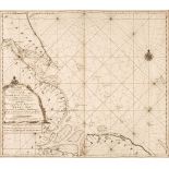
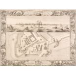
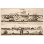
Sea Chart. Van Keulen (G.), A New Enereasing Compass Map of the East-Coast of England..., 1760
Sea Chart. Van Keulen (G.), A New Enereasing Compass Map of the East-Coast of England; Extending from Eckles to Flamborough-Head containing the Ri...
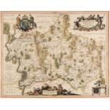
Somerset. Blaeu (J.), Somersetensis Comitatus. Somerset Shire, Amsterdam, circa 1645, engraved map with contemporary outline colouring, 385 x 500 ...
Somerset. Speed (John), Somerset-Shire Described and into Hundreds divided with the plot of the famous and most wholsom waters and citie of the Ba...
Suffolk. Saxton (Christopher), Suffolciae Comitatus continens in Se oppida Mercatoria..., 1579
Suffolk. Saxton (Christopher), Suffolciae Comitatus continens in Se oppida Mercatoria 25 Pagos et Villas 464 una cum singulis hundredis et flumini...
Surrey & its Environs. A collection of 32 road and regional maps, 18th & 19th century, engraved road maps, regional maps and maps of the environs ...
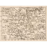
Surrey. (Bill (John), Surrey, [1626], uncoloured engraved map, large margins, 90 x 120 mm, English text on the versoQty: (1)Footnote: Originally p...
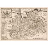
Surrey. A collection of 10 maps, 17th & 18th century, engraved maps, seven with hand-colouring, including Simmons (Matthew). Surrey, [1643], hand-...
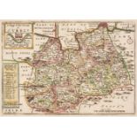
Surrey. A collection of 18 maps, 18th & 19th century, engraved maps, several with hand-colouring, including examples by Wallis/Oddy, Leigh, Wallis...
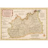
Surrey. A collection of 25 county maps, 18th & 19th century, engraved county maps, several with hand-colouring, including examples by Blome, Carin...
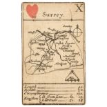
Surrey. Morden (Robert), Playing card map of Surrey, circa 1676, engraved playing card map (10 of hearts) with the suite in contemporary hand-colo...
Tahiti & South Sea Islands. Cook (James), Carte de L'Isle D'Otahiti par le Lieutenant J. Cook, 1774, uncoloured engraved map, some staining and of...
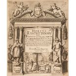
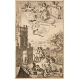
Title Pages & Frontispieces. A collection of approximately 110 engravings, 17th - 19th century
Title Pages & Frontispieces. A collection of approximately 110 engravings, 17th - 19th century, engraved title pages, frontispieces and maps from ...
Title Pages. A collection of approximately 100 engravings, 17th - 19th century, engraved title pages, frontispieces and portraits from a variety o...
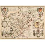
Wales. Blaeu (Johannes), Five county maps, Ceretica sive Cardiganensis Comitatus Anglis Cardigan Shire, Denbigiensis Comitatus et Comitatus Flinte...

Wales. Drayton (Michael), Two allegorical maps of Wales, circa 1612, two uncoloured engraved allegorical maps, one of Pembroke and Carmarthen and ...
Wales. Ortelius (Abraham & Lhuyd Humphrey), Cambriae Typus Auctore Humfredo Lhuydo Denbigiense Cambrobritano [1584 or later], engraved map with sp...
Wales. Saxton (Christopher & Lea Philip), Merioneth and Montgomery Described by C. S. Corrected and Amended by P. Lea [1689], hand-coloured engrav...
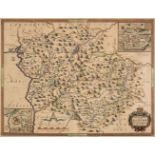
Wales. Speed (John), Four county maps, Merionethshire Described, George Humble circa 1627, Montgomeryshire, John Sudbury & George Humble, circa 16...
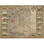
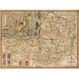
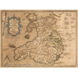
Wales. Speed (John), Wales, John Sudbury & George Humble, circa 1627, hand-coloured engraved map, inset views of Bangor, St Asaph, S. Davids and L...
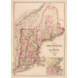
Walling (H. F. & Gray O. W.). Official Topographical Atlas of Massachusetts from Astronomical, Trigonometrical and Various Local Surveys, Stedman,...
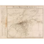
Warsaw. Bach (Joseph), Plan Miasta Warszawy (Plan von der Stadt Warschau), Dresden 1809, large uncoloured engraved map, sectionalised and laid on ...
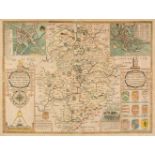
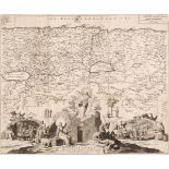
Warwickshire. Speed (John), The Counti of Warwick. The Shire Towne and City of Coventre described, Thomas Bassett & Richard Chiswell [1676], hand-...
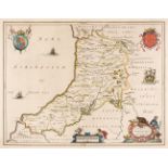
West Wales. Saxton (Christopher & Lea Philip), Radnor, Breknoke, Cardigan and Carmarthen Shires, Discribed by C. S. Corrected and Amended with man...
Wiltshire. Blaeu (Johannes), Wiltonia sive comitatus Wiltoniensis, Anglis Wilshire, circa 1645
Wiltshire. Blaeu (Johannes), Wiltonia sive comitatus Wiltoniensis, Anglis Wilshire, Amsterdam, circa 1645, engraved map with contemporary hand-col...
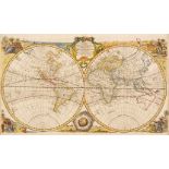
World. Bowen (Emanuel), A New & Accurate Map of all the Known World..., circa 1740, hand-coloured engraved map, old folds, slight dust soiling, fo...
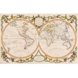
World. Conder (Thomas), An Accurate Map of the World, Comprehending All the Discoveries in Both Hemispheres Carefully Drawn from the Best Authorit...
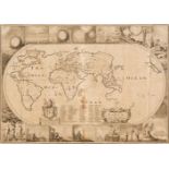
World. Moxon (Joseph), A Map of all the World and how after the Flood it was Divided among the Sons of Noah [1671 or later], uncoloured engraved m...
![World. Ruscelli (Girolamo), Orbis Descriptio, Venice [1561]](https://portal-images.azureedge.net/auctions-2021/srdom10181/images/473049c4-7de1-4725-9b34-adc900f69491.jpg?w=155&h=155)
World. Ruscelli (Girolamo), Orbis Descriptio, Venice [1561], hand-coloured engraved map, very slight spotting, some finger soiling and slight crea...
Albums. A group of 5 albums, containing approximately 390 engravings and etchings, mainly 18th century, laid down on paper, including approximatel...
Aldin (Cecil). 'Here's to the Hound with his Nose upon the Ground', Lawrence & Jellicoe, 1908, chromolithograph, signed by the artist in pencil to...
Aldin (Cecil). The Connoisseurs - A Bowl of Punch, circa 1914, chromolithograph, slight damage to the lower right corner, slight creasing, 385 x 5...
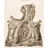
Anatomy. Caldani (Leopoldo Marco Antonio), 43 engraved plates, originally published in "Icones Anatomicae, Venice, circa 1813, uncoloured engraved...
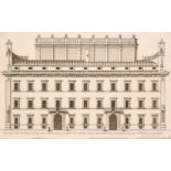
Architecture. Falda (Giovanni Battista), Four Architectural Elevations - Palazzo lo Fece il Fare il Cardinal Dezza, Palazzo Delli Reverendi Monici...
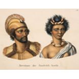
Asia & India. A collection of approximately 325 prints & engravings, mostly 19th century, hand-coloured engravings and lithographs of costume, cus...
Australasia. A collection of approximately 500 prints & engravings, mostly 19th century, engravings and lithographs, many hand-coloured, of topogr...
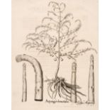
Besler (Basilius). Asparagus domesticus & Flammula recta, Nuremberg, circa 1613, two uncoloured engravings, each approximately 485 x 390 mm, Latin...
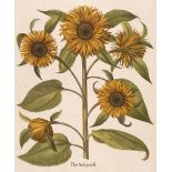
Besler (Basilius). Flos Solis prolifer, Nuremburg, 1613 - 1713, hand-coloured print, engraved by Heinrich Ulrich, one small vertical crease, small...
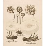
Besler (Basilius). Nymphaea alba maior, Nuremberg 1613 - 1713, uncoloured engraving, slight worming to the right-hand margin, but not affecting th...
British Topography. A collection of approximately 110 engravings, 19th century, but later restrikes
British Topography. A collection of approximately 110 engravings, 19th century, but later 20th-century restrikes, coloured and uncoloured topograp...
British Topography. A collection of approximately 320 prints, mostly 19th century, engravings and lithographs of British topographical scenery, in...
British Topography. A collection of approximately 700 engravings, mostly 19th century, uncoloured engravings of British topographical scenes, incl...
British Topography. A collection of approximately 800 engravings, mostly 18th & 19th century
British Topographical Views. A collection of approximately 800 engravings, mostly 18th & 19th century, engravings and etchings, including examples...
British Topography. A large collection of approximately 1000 engravings, 18th & 19th century
British Topography. A large collection of approximately 1000 engravings, 18th & 19th century, uncoloured engravings, including examples by Roberts...
Bunbury (Henry). Fifteen engravings of Shakespearean Scenes, Thomas Macklin, 1793, hand-coloured engravings by Vanden Bergh, Chapman, Macklin, Gar...