Filtered by:
- Sale Section,
- Category
- List
- Grid
A subscription to the Price Guide is required to view results for auctions ten days or older. Click here for more information
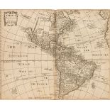

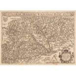
Heylyn (Peter). Cosmography ... containing the Chorography and History of the Whole World, 1682
Heylyn (Peter). Cosmography in Four Books. Containing the Chorography and History of the Whole World: and all the Principal Kingdoms, Provinces, S...
Wilson (James). A Missionary Voyage to the Southern Pacific Ocean, performed in the Years 1796, 1797, 1798, in the Ship Duff, commander by Captain...
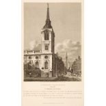
Clarke (Charles). Architectura Ecclesiastica Londini; or Graphical Survey of the Cathedral, Collegiate and Parochial Churches, in London, Southwar...
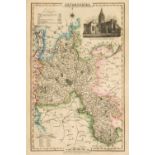
Slater (Isaac, publisher). I. Slater's New British Atlas comprising the Counties of England...,
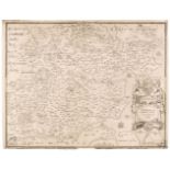
Slater (Isaac, late Pigot & Slater, publisher). I. Slater's New British Atlas comprising the Counties of England..., 1857, four large folding engr...
Africa. Mercator (Gerard & Hondius Henricus), Abissinorum sive Pretiosi Joannis Imperiu, circa 1610, hand-coloured engraved map, ornate strapwork ...
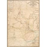
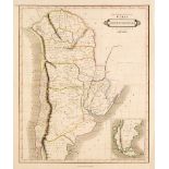
Argentina. Field (William, publisher), Republica Argentina Mapa General de Los Ferrocarriles..., McCorquodale & Co. Limited, 1911, colour lithogra...
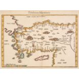
Asia Minor. Fries (Lorenz), Tabula nova Asiae minoris, circa 1541, hand-coloured woodblock map, 290 x 390 mm, Latin text on verso, together with B...
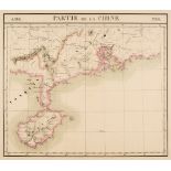
Asia. Vandermaelen (Phillipe Marie Guillaume), Seven maps of Asia (nos. 98, Partie de la Chine, 106, Partie de la Cochinchine, 97, Tonquin, 99, Pa...
Bedfordshire & Buckinghamshire. A collection of 18 maps, 17th - 19th century, including Speed (John). Bedford Shire and the Situation of Bedford D...
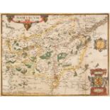
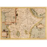
Belgium & Germany. Ortelius Abraham), Namurcum Comitatus, circa 1630, hand-coloured engraved map, two additional vertical folds, folds strengthene...
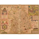
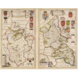
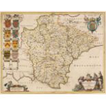
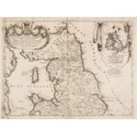
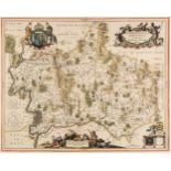
Blaeu (Johannes). Comitatus Northantonensis vernacule Northamtonshire [and] Westmoria comitatus Anglice Westmorland, Amsterdam, circa 1645, two en...
British County Maps. A collection of approximately 120 maps, 17th - 19th century, including Speed (John). Shropshyre Described The Sittuation of S...
British County Maps. A collection of approximately 140 maps, 17th - 19th century, engraved county, regional and road maps, together with city and ...
British County Maps. A collection of nine maps, mostly 17th century, including, Seller (John). Midlesex Actually Surveyd and Deliniated, sold by P...
British Isles. A large collection of approximately 350 county and regional maps, 17th - 19th century, engraved maps of British counties and region...
British Isles. A mixed collection of approximately 175 maps, mostly 19th century, engraved and lithographic maps of the British Isles, England & W...
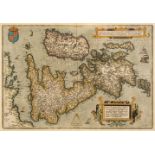
British Isles. Ortelius (Abraham), Angliae, Scotiae et Hiberniae sive Britannicar: Insularum Descriptio, 1598, hand-coloured engraved map orientat...
British Isles. Sanson (Nicolas), Three Regional Maps, Provinces d'West autre fois Royaume d'Westsex..., Anciens Royaumes de Kent, D'Essex et de Su...
British Isles. Speed (John), Britain as it was divided in the tyme of the Englishe Saxons..., 1676
British Isles. Speed (John), Britain as it was divided in the tyme of the Englishe Saxons especially during their Heptarchy, Thomas Bassett & Rich...
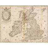
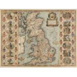
British Isles. Speed (John), The Kingdome of Great Britaine and Ireland, 1st edition, John Sudbury & George Humble [1611], hand-coloured engraved ...
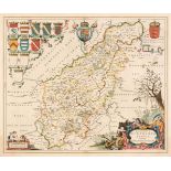
Buckinghamshire & Bedfordshire. Blaeu (Johannes), Bedfordiensis Comitatus Anglis Bedford Shire [and] Buckinghamiensis Comitatus Anglis Buckingham ...
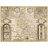
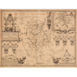
Buckinghamshire. Speed (John), Buckingham both Shyre and Shire Towne describ. George Humble, 1st edition, [1611], hand-coloured engraved map, inse...
Cardiganshire. Speed (John), Cardigan Shyre Described with the due forme of the Shire town as it was surveyed by J. S. in 1610, Thomas Bassett & R...
Cary (John & Stockdale John). A Collection of 51 British County Maps, 1806, uncoloured engraved county and regional maps, mostly double-page, lack...
![Cary (John). Cary's New Map of England and Wales with part of Scotland, 1794 [1804]](https://portal-images.azureedge.net/auctions-2021/srdom10181/images/511b4a32-a5fa-4cbf-97cb-adc900f65f82.jpg?w=155&h=155)
Cary (John). Cary's New Map of England and Wales with part of Scotland on which are carefully laid down all the Direct and Principal Cross Roads, ...
Central & South America. A collection of 25 maps, 18th & 19th century, engraved and lithographic maps of the sub-continent, regions and countries,...
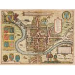
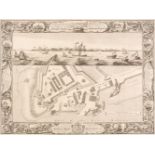
Chester. Braun (Georg & Hogenberg Frans), Cestria (vulgo) Chester Angliae Civitas, [1581], hand-coloured engraved city plan, some spotting and cre...
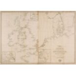
Collins (Captain Greenville). Six sea charts, The East Coast of England, The Islands of Orkney, The Harbours of Orkney, The Citty of Aberdeene and...
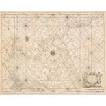
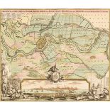
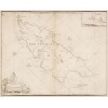
Collins (Captain Greenville). Untitled chart of the East coast of England, circa 1700, large hand-coloured engraved chart, showing the coastline f...
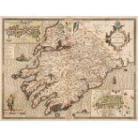
Devon. Blaeu (Johannes), Devonia vulgo Devonshire, Amsterdam, circa 1645, engraved map with contemporary hand-colouring, decorative cartouche and ...
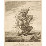
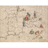
Dighton (Robert). Geography Bewitched! Two caricature maps of Scotland & Ireland, circa 1850
Dighton (Robert). Geography Bewitched! or, a Droll Caricature Map of Scotland [and] Geography Bewitched! or, a Droll Caricature Map of Ireland. Th...
England & Wales. Coronelli (Vincenzo Maria), Parte settentrionale de Regno d'Inghilterra..., [together with] Parte meridionale del regno d'Inghilt...
England & Wales. Ortelius (Abraham & Lhuyd Humphrey), Angliae Regni Florentissimi nova descriptio auctore Humfredo Lhuyd Denbygiense [1573 - 84], ...
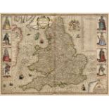
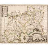
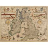
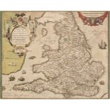
England & Wales. Speed (John), The Kingdome of England, 1st edition, John Sudbury & George Humble [1611], hand-coloured engraved 'carte-a-figures'...
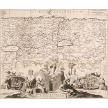
Essex. Saxton (Christopher & Web William), Essexiae Comitat Nova vera ac absoluta descriptio..., circa 1645, uncoloured engraved map, decorative c...
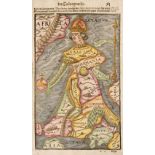
Europe. Munster (Sebastian), Untitled map of Europe as a woman, circa 1580, hand-coloured engraved allegorical map of Europe as a queen, with Iber...
Foreign Maps. A collection of approximately 140 maps, 17th - 19th century, engraved and lithographic maps, of countries, regions and cities, inclu...
Foreign Maps. A collection of approximately 230 maps. mostly 18th & 19th century, engraved maps of countries, regions and town plans, including ex...
Foreign maps. A collection of approximately 90 maps, 18th & 19th century, engraved maps, many hand-coloured, including maps of North & South Ameri...
Germany. Homann (Johann Baptist, heirs of), Die Herzogl. Holstein Gottorp Residenz-See und Handelsstadt Kiel..., Nuremberg, circa 1735, two engrav...
Germany. Homann (Johann Baptist), Prospect und Grundris der Keiserl Freyen Reichs und Ansee Stadt Bremen samt ihrer Gegend, Nuremberg, circa 1716,...
Hungary. Ortelius (Abraham, Hungariae Descriptio, Wolfgang Lazio Auct [1603], uncoloured engraved map, slight staining, 355 x 495 mm, Latin text o...
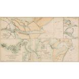
Ireland. Purdey (Isaac, after). Four sheets of Harbours, Ports & Rivers, Admiralty Surveys, circa 1840, folding colour lithographic charts and map...
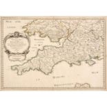
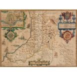
Ireland. Speed (John), The Province of Mounster, John Sunbury & George Humble, circa 1627, hand-coloured engraved map, inset town plans of Limeric...
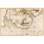
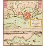
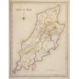
Isle of Man. Collins (Capt. Greenville), The Isle of Man, circa 1700, uncoloured engraved sea chart, inset view of Peel Castle, slight staining to...
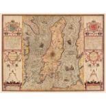
Isle of Man. Speed (John), The Isle of Man exactly described and into Several Parishes divided..., 1st edition, 1611, hand-coloured engraved map l...
Lewis (Samuel). A Topographical Dictionary of England..., 5 volumes (including the atlas volume), together with A Topographical Dictionary of Wale...
Lighthouses. Laurie (R. H. publisher), A Chart exhibiting the Lighthouses and Light Vessels on the Coasts of Great Britain & Ireland and also thos...
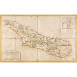
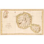
Madagascar. Bellin (Jacques Nicolas), Carte de l'Isle de Madagascar dressée au Depost des Cartes, Plans et Journaux de la Marine..., Depot de la M...
Manchester. Laurent (C. surveyor), A Topographical Plan of Manchester and Salford, with the Adjacent Parts shewing also the Different Allotments o...
Maps. A mixed collection of approximately 175 maps, mostly 18th & 19th century, engraved and lithographic maps, battle plans and charts of foreign...
Middlesex & Hertfordshire. Jansson (Jan), Middelsexiae cum Hertfordiae comitatu Midlesex & Hertford Shire, Amsterdam, circa 1650, engraved map wit...
![Morden (Robert). A collection of 30 county maps [1695 or later]](https://portal-images.azureedge.net/auctions-2021/srdom10181/images/93591b61-ba64-4d18-a046-adc900f674b7.jpg?w=155&h=155)
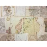
Morden (Robert). A collection of 30 county maps [1695 or later], engraved maps, 29 with later hand-colouring, occasional duplicates, slight spotti...
North America. Buchon (Jean Alexandre), A collection of eight maps of North American States, Carte Géographique, Statistique et Historique du..., ...
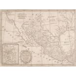
North America. Kitchin (Thomas), Mexico or New Spain in which the Motions of Cortes may be Traced..., W. Strahan & T. Cadell, 1793, uncoloured eng...
Northern Europe. Ruscelli (Giralomo), Tabula Europae IIII, 1561 - 74, hand-coloured engraved map on a trapezoidal projection, slight text show thr...
Pine (John). Two untitled charts showing the progress of the Spanish Armada (nos. 3 & 4), 1739
Pine (John). Two untitled charts showing the progress of the Spanish Armada (nos. 3 & 4), 1739, two hand-coloured charts on one sheet (as publishe...
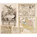
Poland. A collection of nine maps, mostly 18th century, engraved maps, six with hand-colouring, including examples by Nilson, Gibson, Bowen/Meijer...
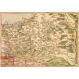
Poland. A collection of ten maps, 16th - 18th century, engraved maps, five with hand-colouring, including examples by Hogenberg, Botero, Munster, ...
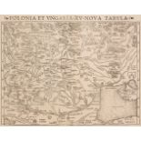
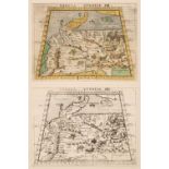
Poland. Munster (Sebastian), Polonia et Ungaria XV Nova Tabula, circa 1550, uncoloured woodblock map of Poland, Lithuania, Moscovy and the Balkans...