Filtered by:
- Sale Section
- List
- Grid
A subscription to the Price Guide is required to view results for auctions ten days or older. Click here for more information
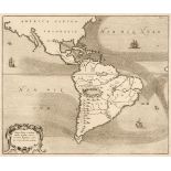

Americas. Kircher (Athanasius), Mappa Fluxus et Refluxus Rationes in Isthmo Americano, in Freto Magellanico, caeterisque Americae Littoribus Exhib...
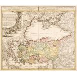
Asia Minor. Homann (Johann Baptiste, heirs of), Carte de l'Asie Mineure ou de la Natolie et du Pont Euxin..., Nuremberg, 1743, engraved map with c...
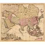
Asia. De Wit (F.), Tabula Tartariae et Majoris Partis Regni Chinae, Amsterdam, circa 1680, engraved map with contemporary outline colouring, sligh...
Asia. Solinus (Gaius & Munster Sebastian), Asia Maior, Basel [1538], uncoloured woodblock map originally published in Gaius Solinus's 'Polyhistor,...
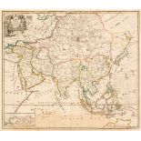
Asia. Ottens (Reiner & Joshua), Exactissima Asiae Delineatio in Praecipuas Regiones..., circa 1745, engraved map with contemporary outline colouri...
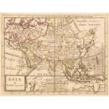
Asia. Senex (John), A New Map of Asia from the latest Observations, Most Humbly Inscribed to the Right Honourable George, Earl of Warrington, circ...
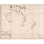
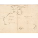
Australia. Bowen (Emanuel), A Complete Map of the Southern Continent Survey'd by Capt. Abel Tasman & Depicted by Order of the East India Company i...
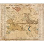
Australia. Buffon (George), Carte des Delinaisions et Inclinasions de L'Aiguille..., circa 1780
Australia. Buffon (George Louis le Clerc), Carte des Déclinaisons et Inclinaisons de l'Aiguille Aimantée Redigée d'après la Table des Observations...
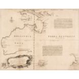
Australia. Thevonot (Mechisedech), Hollandia Nova detecta 1644 Terre Australe découverte l'an 1644, Paris, circa 1692, uncoloured engraved map, ol...
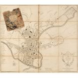
Bath. Chantry (T. Surveyor), A New and Accurate Plan of the City of Bath, A. Taylor & W. Meyler, January 1st. 1801, uncoloured engraved map, secti...
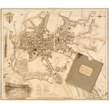
Bath. Donne (B.), A New and Correct Plan of the City of Bath from a recent Survey, published by and for H. Goodwin and sold by the Principal Map a...
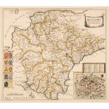
* Berkshire. Blaeu (Johannes), Bercheria vernacule Barkshire, Amsterdam, circa 1648, engraved map with contemporary outline colouring, 385 x 500 m...
* Berkshire. Blaeu (Johannes), Bercheria vernacule Barkshire, Amsterdam, circa 1648, engraved map with contemporary outline colouring, 385 x 500 m...
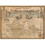
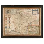
* Berkshire. Speed (John), Barkshire Described, J. Sudbury & G. Humble, circa 1627, hand-coloured engraved map, panorama of Windsor Castle, slight...
* Bodenehr (Gabriel). Dantzig, die Hauptstatt in dem Koniglich Polnischen Preussen, circa, 1704, uncoloured engraved panorama on two conjoined she...
Celestial Chart. Homann (J. B.). Globi Coelestis in Tabulas Planas Redacti Pars II, circa 1730
Celestial Chart. Homann (Johann Baptist & Dopplemayer Johann). Globi Coelestis in Tabulas Planas Redacti Pars II. in qua Longitudines Stellarum Fi...
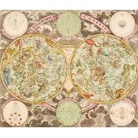
Celestial Chart. Homann (Johann Baptist, heirs of), Planisphaerium Caeleste, G. C. Eimmart, circa 1735, engraved twin hemisphere celestial chart w...
China, East Indies and Australasia. A collection of 22 maps, 18th & 19th century, engraved and lithographic maps of China, East Indies, Australasi...
Colton (Joseph Hutchins) Colton's Atlas of America..., volume 1 (part only) circa 1877, lacking title and preliminaries but retaining index and de...
Devon. Saxton (Christopher & Lea Philip), Devon-Shire Described by C. Saxton Corrected, Amended and many Additions by P. Lea, circa 1690, engraved...
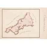
* Devon. Speed (John), Devonshire with Excester Described and the Armes of such Nobles as have borne the titles of them, John Sudbury & George Hum...
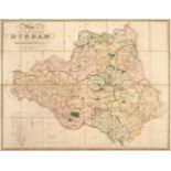
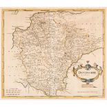
Durham. Hobson (William Colling), This Map of the County Palatine of Durham is most respectfully dedicated to the Nobility, Clergy, Gentry &c. &c....
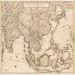
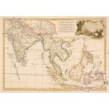
East Indies. Covens (Jean & Mortier Corneille), Carte des Indes et de la Chine..., Amsterdam, circa 1730, engraved map with contemporary outline c...
* Eastern Europe. Waldseemuller, Sarmatia (Tabula VIII Europae), Laurent Fries, Lyon [1535], hand-coloured woodblock Ptolemaic map of Western Russ...
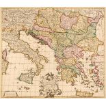
Eastern Mediterranean and the Dalmatian Coast. De La Feuille (Jacob), Totius Danubii Nova & Accuratiss. Tabula, Universam Simul Turciam Europaeam ...
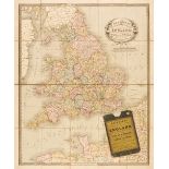
England & Wales. Cruchley (George Frederick), Cruchley's New Travelling Map and Itinerary comprising the whole of England, with part of Scotland &...
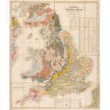
England & Wales. Smith (William), A New Geological Map of England and Wales with the Inland Navigations exhibiting the Districts of Coal and other...
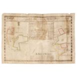
Estate Plan. McClatchy (James), A Map of that Proportion of the Lands of Ballclander, Belonging to Mrs Margaret Dixon otherwise Ross Shewing the A...
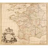
France. Senex (John), A New map of France shewing the Roads and Post Stages thro-out that Kingdom as also the errors of Sanson's map compared..., ...
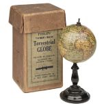
* Globe. Philips' Three-Inch Terrestrial Globe, George Philip & Son Ltd, circa 1910, 12 engraved gores with contemporary outline colouring, adjust...
Holy Land and Palestine. Weigel (Christopher), Terra Sancta in XII olim Tribus nunc VI Provincias Dispertita..., [1712], engraved map with contemp...
Italy. Bordiga (F.), Carta amministrativa del Regno d'Italia co' suoi stabilimenti politici, militari, civili e religiosi e con una parte degli St...
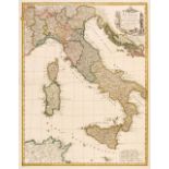
Italy. Homann (Johann Baptise, heirs of), Italia in suos Staus divisa ex d'Anvilliano Rizzi Zannonioque prototypis desumta..., 1790, engraved map ...
Kent. Cary (John), Geological Map of Kent by W. Smith, Mineral Surveyor, 1819, engraved map with contemporary hand-colouring identifying the vario...
Lewis (Samuel). A Topographical Dictionary of England ..., Atlas volume only, London: S. Lewis and Co., 1844, printed title, folding engraved map ...
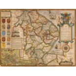
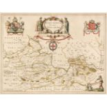
* Lincolnshire. Speed (John), The Countie and Citie of Lyncolne Described, with the Armes of them that have bene Earles thereof since the Conquest...
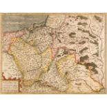
* Lithuania. Homann (Johann Baptist heirs of), Magnus Ducatus Lithuaniae in suos Palatinatus et Districtus Divisus. delineatus a Rever Patre Ioann...

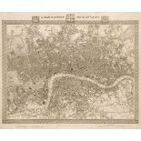
London. Cole (Benjamin), Five ward plans: Langborn Ward & Candlewick Ward (2 copies), Cheap Ward, Farringdon Ward [and] Breadstreet Ward and Cordw...
Lyddon (William). An Atlas of the Counties of England and Wales..., Upper Easton House, June 1824, a manuscript atlas with a calligraphic pen & in...
Maps. A collection of 36 British & foreign maps, 17th - 19th century, engraved map, many with hand-colouring, mostly foreign countries, cities and...
Morden (Robert). Devonshire, Gloucestershire, Midlesex & Worcestershire [1695 or later], together four hand-coloured engraved maps, slight toning ...

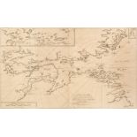
Mount (William & Page Thomas). [The English Pilot, Part II, The Northern Sea], circa 1760, lacking title and preliminaries, containing 16 (only) u...
* Munster (Sebastian). Frankfurt an der Oder..., circa 1560, woodblock city plan with contemporary hand-colouring, 205 x 290 mm, displayed in a do...
* Munster (Sebastian). Nouvelle description de Poloigne & Hongrie, Basel, circa 1560, woodblock map with contemporary hand-colouring, very slight ...
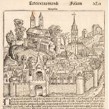
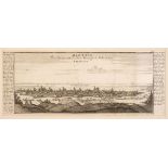
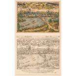
Naples. Schedel (Hartmann), Neapolis, Nuremberg, circa 1497, uncoloured woodblock 'fantasy' view of Naples, originally published in the 'Nuremberg...
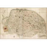
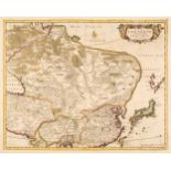
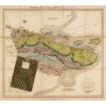
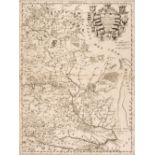
* Norfolk. Donald (Thos. & Milne Thos.), A Topographical Map of the County of Norfolk, Surveyed and Measured in the Years 1790, 91, 92, 93 and 94....
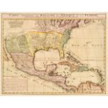
North & Central America. Chatelain (Henri Abraham),Carte contenant le Royaume du Mexique et la Floride..., Paris [1719], engraved map with contemp...
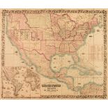
North America. Colton (J. H.), Colton's Map of the United States, Mexico, The West Indies &c, New York, 1861 [but a slightly later impression], li...
Norway. Page (Thomas & Mount & Page W. & John), A New and Exact Map of Part of the Coast of Norway beginning at Long Sound wth. the East & N E Coa...
* Ogilby (John). The Road from London to Aberistwith on the Sea coast com. Cardigan, Wherein are included the Roads to Oxford and Worcester Actual...

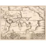
Pacific Ocean. Jansson (Jan), Mar del Zur Hispanis Mare Pacificum, Amsterdam, circa 1650, engraved map with contemporary outline colouring, insula...
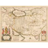
Persia. Blaeu (Johannes), Persia sive Sophorum Regnum, Amsterdam, circa 1635, engraved map with contemporary outline colouring, decorative cartouc...
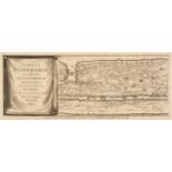
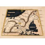
Peutinger Table. Jansson (Jan), Tabula Itineraria ex illustri Peutingerorum Bibliotheca, 1652
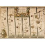
Peutinger Table. Jansson (Jan), Tabula Itineraria ex illustri Peutingerorum Bibliotheca..., Amsterdam, circa 1652, eight uncoloured engraved route...
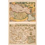
* Poland. Ortelius (Abraham), Poloniae, Lithuaniaeq Descriptio, Auctore Wenceslao Godreccio ...
* Poland. Ortelius (Abraham), Poloniae, Lithuaniaeq Descriptio, Auctore Wenceslao Godreccio et correctore Andrea Pograbio Pilsnensi, [1595 or late...

* Poland. Bazewicz (J. M.), Polska W. Trzech Zaborach G. Tranicach Przedrozbiorowwch..., 1922
* Poland. Bazewicz (Jósef Micha), Polska W. Trzech Zaborach G. Tranicach Przedrozbiorowwch W 1770 R. Oraz W Innych Wazniejszych Okresach Historycz...
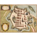
* Poland. Braun (Georg & Hogenberg Franz), Zamoscium Nova Poloniae civitas..., 1617, engraved city plan with contemporary hand-colouring, 355 x 46...
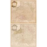
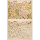
* Poland. Coronelli (Vicenzo Maria), Polonia Parte Occidentale, & Silesia Inferiore, circa 1690
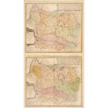
* Poland. Coronelli (Vicenzo Maria), Polonia Parte Occidentale..., & Silesia Inferiore..., Venice, circa 1690, two uncoloured engraved maps, large...
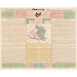
* Poland. De Mancy (Adrian Jarry), Tableau Historique Des Revolutions de Pologne (Methode de la Sage, Ct. de las Cases, Paris, 1832, engraved map ...
* Poland. De Vaugondy (Robert), Le Royaume de Pologne..., 1767, engraved map with contemporary outline colouring and some later enhancement to the...
* Poland. Du Val (Pierre), La Cours de L'Elbe et de L'Oder où sont Electorats de Saxe et de Brandebourg, Les Duchés de Mekelbourg et de Pomeranie,...