Filtered by:
- Category,
- Item Type
- List
- Grid
A subscription to the Price Guide is required to view results for auctions ten days or older. Click here for more information

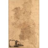
Lewis (Samuel). An Atlas comprising Maps of the Several Counties, divided into Unions and of the Islands of Guernsey, Jersey and Man; with a Map o...
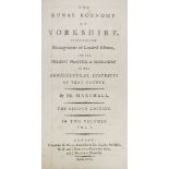
Marshall (William). The Rural Economy of Yorkshire, 2 volumes, 2nd edition, London: G. Nicol, G.G. & J. Robinson and J. Bebrett, 1796, folding & d...
Bowen (Emanuel & Owen John). Collection of approximately 80 road maps, 1720 or later, uncoloured engraved strip road maps, many printed 'back-to-b...
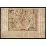
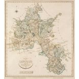
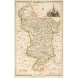
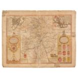
Buckinghamshire. Jefferies (Thomas), The County of Buckingham surveyed in MDCCLXVI, VII and VIII, 1st edition, March 24th, 1770, large scale engra...
Cary (John). Cary's New Map of England and Wales, with part of Scotland, on which are carefully laid down all the Direct and Principal Cross Roads...
* Devon. Blaeu (Johannes), Devonia vulgo Devon-Shire, Amsterdam, [1645 or later], engraved map with contemporary outline colouring, 390 x 495 mm, ...
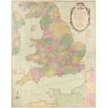
England & Wales. Carington Bowles (publisher), Bowles's New and Accurate Map of England and Wales; Comprehending all the Cities, Boroughs, markets...
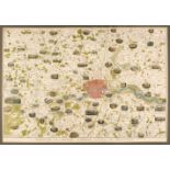
Estate plan. Messrs. Knight Frank & Rutley Publishers), Plan of the Moor Park Estate, Hertfordshire & Middlesex, for sale by Auction, 1919, large ...
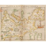
Europe. Munster (Sebastian), Tabula Nova Prima Europa, Basel, circa 1550, hand-coloured woodblock map of Europe orientated to the south with a lar...
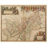
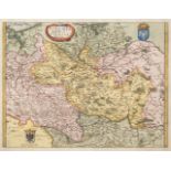
* Gloucestershire. Jansson (Jan), Glocestria Ducatus cum Monumethensi Comitatu..., circa 1650
* Gloucestershire & Monmouthshire. Jansson (Jan), Glocestria Ducatus cum Monumethensi Comitatu Glocester Shire & Monmouthshire, Amsterdam, circa 1...
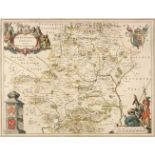
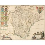
* Hertfordshire. Blaeu (Johannes), Hertfordia comitatus vernacule Hertfordshire, Amsterdam, circa 1648, engraved map with contemporary outline col...
Holy Land. Munster (Sebastian), Das Heilig Judisch Landt mit Ausztheilung der Zwolff Geschlechter, Basel, circa 1580, uncoloured woodblock map, or...
Ireland. Ordnance Survey. A collection of seven Townland Surveys of Irish Counties: - Tipperary, Clare, Waterford, Wicklow, Armagh, Longford [and]...
Leicestershire. Speed (John), Leicester both Countye and Citie described, The Honorable Famylies that have had the titles of earls thereof. With o...
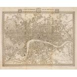
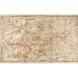
London. Dower (John), Environs of London - Windsor Castle to Gravesend, Illustrated London News, 1855, hand-coloured pictorial map of the environs...
London. Sampson Low, Marston & Co. Ltd (publishers). The "District Railway" Map of London, 6th edition, circa 1897, colour lithographic map, secti...
Manchester. Laurent (C.). A Topographical Plan of Manchester and Salford with the adjacent parts; shewing also the different allotments of land pr...
Maps. A mixed collection of approximately 120 maps, 18th & 19th century, engraved and lithographic maps of the British isles and foreign countries...
Maps. A mixed collection of approximately fifty maps, mostly 19th century, engraved and lithographic foreign maps, including several mounted on ba...
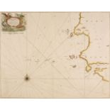
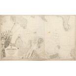
Maps. Collins (Capt. Greenville), Milford Haven and the Islands adjacent..., circa 1700, hand-coloured engraved chart, decorative cartouche, compa...
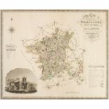
Maps. Greenwood (C. & J.), Map of the County of Worcester from an actual survey..., Map of the County of Huntingdon from an actual survey..., Map ...
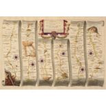
Ogilby (John). The Road from London to Rye in com. Sussex, The Road from London to Hith in com. Kent including the Road by Maidstone [and] The Roa...
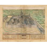
Ortelius (Abraham). Daphne [and] Scenographia Totius Fabricae S. Lavrentii in Escoriali, circa 1612, two hand-coloured engraved aerial prospects, ...
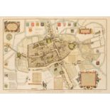
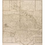
Oxford. Skelton (Joseph), Skelton's Reduced Engraving of the Original Plan of Oxford, taken by Ralph Agas in the year 1578, J. Skelton, Magdalen B...
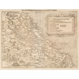
Oxfordshire. Cary (John), A New Map of Oxfordshire Divided into Hundreds exhibiting its Roads, Rivers Parks &c. Feby. 1st. 1821, engraved map with...
Pigot (& Co. publishers). Pigot & Co's Maps of the Counties of Derby, Hereford..., circa 1828
Pigot (& Co. publishers). Pigot & Co's Maps of the Counties of Derby, Hereford, Lincoln, Leicester and Rutland, Monmouth, Nottingham, Salop, Staff...
Poland. Merian (Matthaus). Polonia Regnum et Silesia Ducatus, circa 1638, hand-coloured engraved map, 275 x 360 mm, together with another uncolour...
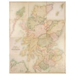
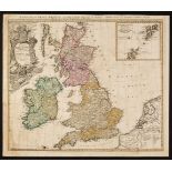
Scotland. Bartholomew (John), Black's New Large Map of Scotland, Compiled from The Ordnance, Admiralty & other Surveys, A & C Balck, Edinburgh, ci...
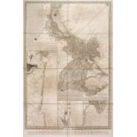
Sea charts. A collection of 17 sea charts of Australia and the West Indies, 20th century, 15 printed sea charts of Australia, including Sydney Har...
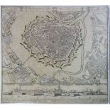
Venice. Unattributed large scale map, 7 sheets (of 10?), circa 1860, large scale uncoloured engraved map on seven sheets numbered 1 - 5, 7 & 10, s...
Warwickshire. Speed (John), The Counti of Warwick, The Shire Towne and Citie of Coventre described, Thomas Bassett & Richard Chiswell, [1676], han...
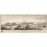
* Buck (Samuel & Nathaniel). The South-West Prospect of the City of Carlisle, 1745, [published Robert Sawyer circa 1775], uncoloured engraved pros...