Refine your search
Sale Section
- Antiquarian Literature and History (65)
- Art Reference (20)
- Autographs and Association Items (57)
- British Topography (The David Wilson Library Part III) (18)
- Civil Engineering, Transport and Topographical Panoramas from the Davi (59)
- Decorative Prints (82)
- General Literature (25)
- General Stock (53)
- Historical Documents and Ephemera (17)
- Maps (85)
- Modern Chess Books: A Private Collection (14)
- Natural History (21)
- Nelson and the Age of Revolution (17)
- Scotland, Highlands and Islands (50)
- Travel & Exploration (17)
Estimate
Category
- Books & Periodicals (313)
- Prints (151)
- Maps (84)
- Arms, Armour & Militaria (21)
- Photographs (5)
- Watercolours (5)
- Collectables (4)
- Sporting Memorabilia & Equipment (4)
- Bank notes (2)
- Chinese Works of Art (1)
- Classic Cars, Motorcycles & Automobilia (1)
- Coins (1)
- Furniture (1)
- Islamic Works of Art (1)
- Kitchenalia (1)
- Models, Toys, Dolls & Games (1)
- Musical Instruments & Memorabilia (1)
- Russian Works of Art (1)
- Sculpture (1)
- Silver & Silver-plated items (1)
Filtered by:
- Item Type
- List
- Grid
A subscription to the Price Guide is required to view results for auctions ten days or older. Click here for more information

Vasco (John J. & Peter D. Cornwell). Zerstörer, The Messerschmitt 110 and its units in 1940, 1st edition, JAC Publications, Norwich, 1995, numerou...
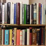
Aviation. A large collection of modern aviation reference, including publications by Air Britain, Ian Allan, Jane's, Osprey, Arms & Armour , PSL, ...
Classical Literature & Art. A large collection of early 20th century classical literature & art
Conant (Kenneth John). Carolingian and Romanesque Architecture 800-1200 [Pelican History of Art], 1st edition, Penguin, 1969, numerous black & whi...

Miscellaneous Reference. A large collection of 19th century & modern miscellaneous reference
Walton (Izaak & Charles Cotton). The Compleat Angler or the Contemplative Man's Recreation..., 2 volumes, The Winchester Edition, Freemantle & Com...
Cummins (Geraldine). The Scripts of Cleophas, a reconstruction of primitive Christian documents, 4th edition, Psychic Press, 1961, some minor toni...

McParland (Edward). Public Architecture in Ireland 1680-1760, 1st edition, Yale University Press, 2001, numerous colour & monochrome illustrations...
Paperbacks. Approximately 700 volumes of miscellaneous Penguin paperbacks, including fiction & non-fiction, all original wrappers, G/VG, 8voQty: (...
Gibbon (Edward). The History of the Decline and Fall of the Roman Empire, 12 volumes, new edition, W. Allason et al., 1818, later inscriptions to ...
E. and J. L. Milner. The Churches, Castles, and Ancient Halls of North Lancashire, volume 1, Lancaster, 1880, 29 black & white illustrations, some...
Conan Doyle (Arthur). The British Campaign in France and Flanders 1914, Hodder and Stoughton, 1917, 14 black & white maps & plans, blind stamps to...
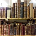
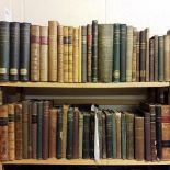
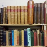
Antiquarian. A large collection of 18th & 19th century literature & reference, including A History of the Earth, and Animated Nature, 3 volumes, b...
Hockney (David). Secret Knowledge, Rediscovering the lost techniques of the Old Masters, 1st edition, Thames & Hudson, 2001, numerous colour & mon...
Mathematics. A large collection of 19th & early 20th century mathematics reference & related
Thomson (William). Mathematical and Physical Papers, 3 volumes, Cambridge University Press, 1882, ex-library copies with associated bookplates & s...
De Boodt (Anselm). Symbola Varia Diversorum Principum, cum facili isagoge D. Ansemi de Boodt Brugensis, tomus tertius, Prague, 1603, engraved alle...
Austen & Co. (publishers). A Safety Guide for those contemplating a trip on the Sea of Matrimony, Chicago, 1906, a used postcard (with a 1908 post...
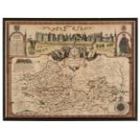
* Berkshire. Speed (John), Barkshire Described, 1st edition, John Sudbury & George Humble, [1611], hand coloured engraved map with a panorama of W...
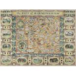
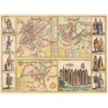
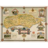
Birmingham. Price (W. H.), The City of Birmingham, 1949, large pictorial city plan, slight creasing, two small repaired marginal closed tears, 705...
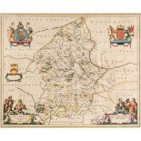
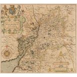
Blaeu (Johannes). Staffordiensis comitatus vulgo Stafford Shire, Amsterdam, circa 1650, engraved map with contemporary outline colouring, large de...
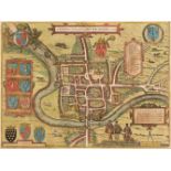
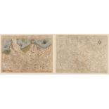
Braun (Georg & Hogenberg Franz). Yorke, Shrowesbury, Lancaster & Richmont, circa 1617, four hand-coloured engraved plans on one sheet (as publishe...
Bruce (John). A Map of Matrimony, circa 1840, engraved map with contemporary hand colouring, printed on a card with blind-stamped embossed foliate...
Cardiganshire. Speed (John), Cardigan Shyre described with the due forme of the Shire-town as it was surveyed by J. S. Anno 1610, John Sudbury and...
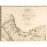
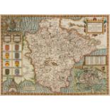
Cheshire. Greenwood (C.), Map of the County Palatine of Chester from an actual survey made in the year 1819, Wm. Fowler Wakefield & C. Greenwood, ...
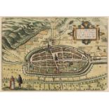
Chester. Braun (Georg & Hogenberg Franz), Cestria (vulgo) Chester Angliae Civitas, Cologne, 1581, engraved city plan with contemporary hand colour...
Clegg (Ernest). Three pictorial English county maps, Sussex, Kent & The West Riding of Yorkshire, John Waddington, Leeds, 1945 - 46, three colour ...
Czechoslovakia. Braun (Georg & Hogenberg Franz). Znaymum vulgo Znaym, Moraviae Civitas Primaria, Amsterdam [1617 - 1657], hand coloured city plan ...
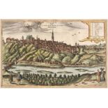
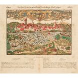
Danzig/Gdansk. Werner (Friedrich Bernhard & Scheffler Thomas), Dantiscum vel Gedanum Dantzig, Martin Engelbrecht, Augsburg, 1734, uncoloured prosp...
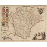
Derbyshire. (Greenwood (C. & J.), Map of the County of Derby, from an actual survey made in the years 1824 & 1825..., Greenwood, Pringle & Co., 18...
* Devon. Blaeu (Johannes), Devonia vulgo Devon-shire, Amsterdam, circa 1645, engraved map with contemporary outline colouring, decorative cartouch...
* Devon. Speed (John), Devonshire with Excester described and the Armes of such Nobles as have borne the titles of them, John Sudbury & George Hum...
* Dorset. Speed (John), Dorsetshyre with the Shyre Towne Dorchester described, as also the Armes of such noble families as have bene honored with ...
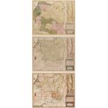
Durham, Cumberland & Westmorland. A collection of 30 maps, 17th - 19th century, engraved maps, including examples by Morden (large and small forma...
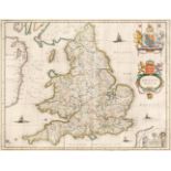
England & Wales. Blaeu (J.), Anglia Regnum, circa 1650, engraved map with contemporary outline colouring, some creasing and strengthening to verso...
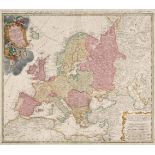
Europe. Homann (Johann Baptist heirs of), Europa Secundum Legitimas Projectionis Stereographicae Regulas..., 1743, engraved map with contemporary ...
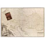
Europe. Mansfeld (J. E.), Post Charte der Kaiserl. Konigl. Erblanden..., George Metzburg, Vienna, 1782, a large engraved map with contemporary out...
Folding maps. A mixed collection of fourteen maps, mostly 19th century, including Lewis (Samuel). A Map of England & Wales Divided into Counties, ...
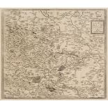
France. A collection of 22 maps of France, 16th - 18th century, engraved regional maps, country maps and town plans, with examples by Faden, Munst...
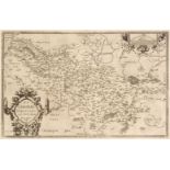
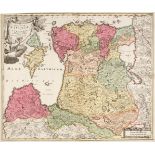
Germany. A collection of thirteen maps, 16th - 18th century, engraved maps of the country and regions, including examples by Ortelius, Gastaldi, L...
Germany. Braun (Georg & Hogenberg Franz), Calcaria Ducatus Clivensis Multis Dotibus Nobile Opp: circa 1618, coloured engraved plan of Kalkar near ...
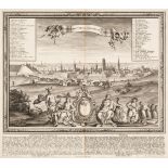
Germany. Munster (Sebastian), Francfurt an der Oder Anno Dni. 1548, Basel, circa 1590, woodblock with contemporary hand colouring, German text bel...
* Germany/Saxony. De Jode (Cornelis), Saxonum Regionis Quatenus eius Gentis Imperium Nomenque Antwerp, 1593, engraved map with contemporary hand c...
* Gloucestershire. Saxton (C. & Hole G.), Glocestriae comitatus olim sedes Dobunorum, [1637], hand-coloured engraved map, large strapwork cartouch...
![* Hollar (Wenceslaus). Plan de Londres, c.1816 [and others]](https://portal-images.azureedge.net/auctions-2020/srdom10158/images/00c20cd0-fc30-49a3-be3a-ac600117d336.jpg?w=155&h=155)
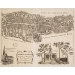
* Hollar (Wenceslaus). Plan de Londres tel quil etoi avant L'Incendie de 1666, Gravé par Hollar, published Robt. Wilkinson circa 1816, uncoloured ...
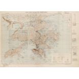
Hong Kong. Hong Kong and the New Territories, 3rd edition (with grid correction), War office publication, 1946, Reprinted from HIND 1015, Mar. 194...
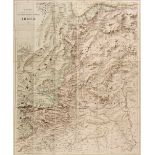
India. Stanford's Sketch map of the North-Western Frontier of India, Edward Stanford, 1897, colour lithographic map, sectionalised and laid on lin...
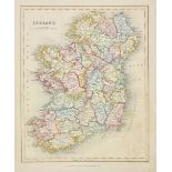
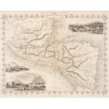
Ireland. A collection of thirty maps, mostly 19th century, engraved maps, many with contemporary outline colouring, with examples by Johnston, Wel...
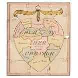
Jigsaw. Love to her Creator. Jigsaw map of love and emotion, circa 1830, engraved 24 piece heartshaped jigsaw of paper on wood construction, with ...
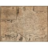
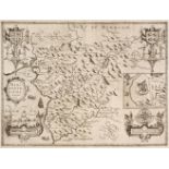
Leicestershire. Prior (John), To the Right Honourable Francis Earl of Huntingdon, Baron Hastings, Hungerford, Newmark, Peverel, Botreaux, Molins, ...
* Lithuania. Mercator (Gerard), Lithuania, circa 1619, engraved map with contemporary outline colouring, some overall toning, slight text show thr...
* Lithuania. Jansson (Jan), Magni Ducatus Lithuaniae Caeterarump Regionum illi Adjacentium exacta descrip..., circa 1680, hand-coloured engraved m...
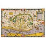
Liverpool. Parry (G. H, designed by A. Preston), A Map of Merseyside with Historical & Literary Allusions, Philip Son & Nephew Ltd, circa 1935, co...
Livonia. Homann (Johannes Baptist), Ducatuum Livoniae et Curlandiae cum vicinis Insulis Nova Exhibitio Geographica, Amsterdam, circa 1720, engrave...
London Ward Plans. A collection of nine ward plans, published in 'The London Magazine', circa 1770, uncoloured engraved ward plans, old folds, eac...
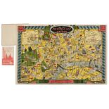
London. Geographia Ltd (publisher). The New Pictorial Map of London, circa 1935, folding chromolithographic pictorial and allegorical map of Londo...
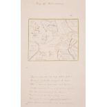
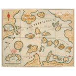
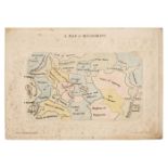
Map of Matrimony. Manuscript allegorical map, circa 1830, a manuscript ink and watercolour allegorical map of matrimony with eight lines of verse ...
Maps. A mixed collection of approx. 250 British & Foreign maps, mostly 19th century, engraved and lithographic foreign and British county and regi...
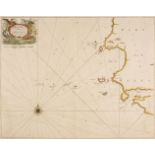
Maps. Collins (Capt. Greenville), Milford Haven and the Islands adjacent..., circa 1700, hand-coloured engraved chart, decorative cartouche, compa...
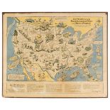
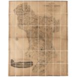
McClandlish (Edward). Bill Whiffletree's Bootlegger's Map of the United States, Hagstrom Compnay Inc. New York, circa 1944, circa 1944, large pict...
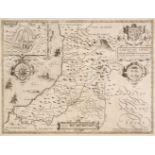
Merionethshire. Speed (John), Merionethshire Described, George Humble, circa 1646, uncoloured engraved map, inset plan of Harlech, decorative stra...
Midland Counties. A collection of 45 maps, 17th - 19th century, engraved maps of Nottinghamshire, Rutland, Leicestershire, Northamptonshire, Bedfo...
Nigeria. Untitled map of Lake Chad, printed for the Intelligence Division, War Office by Messrs. W. & A. K. Johnston, Edward Stanford, 1902, large...