Filtered by:
- Category,
- Item Type
- List
- Grid
A subscription to the Price Guide is required to view results for auctions ten days or older. Click here for more information
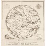

Ancient World. Anonymous, Abbozzo del Mappamondo di F. Mauro Camaldolese Cosmografo Incomparabile alla Meta del Sec. XV. Gia' Esistente Nella Bibl...
Berry (William) . [Composite atlas], London: sold by William Berry at the Sign of the Globe between Charing-Cross and White Hall, 1680-c.1688, con...
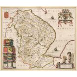
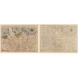
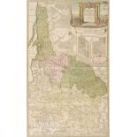
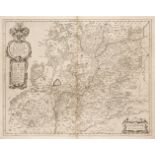
Blaeu (Johannes). Lincolnia Comitatus Anglis Lincoln-shire, Nortfolcia Norfolke [and] Ducatus Eboracensis pars Orientalis; The East Riding of York...
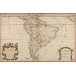
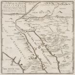
* Brazil. Van der Aa (Pieter), Le Bresil suivant les Nouvelles Observations..., Leiden, circa 1720, engraved map with contemporary outline colouri...
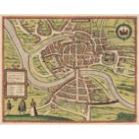
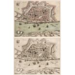
* Breslau. Braun (Georg & Hogenberg Franz), Wratislavia, Cologne, 1587, uncoloured engraved 'birds-eye view', some staining, 365 x 490 mm, mounted...
Bristol. Braun (Georg & Hogenberg Franz), Brightstowe, circa 1581, engraved city plan with contemporary hand colouring, 345 x 440 mm, Latin text o...
British county maps. A mixed collection of approximately 125 maps, 18th & 19th century, engraved maps, including examples by Seller, Seller/Grose,...
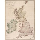
British Isles. A mixed collection of 12 maps, mostly 18th & 19th century, engraved maps, several with hand colouring, including examples by Fembo,...
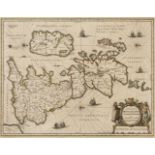
* British Isles. Jansson (Jan & Ortelius Abraham), Insularum Britannicarum Acurata Delineatio ex Geographicis Conatibus Abrahami Ortelii, Amsterda...
Canal maps. A collection of 14 maps of British canals, 18th century, uncoloured engraved maps by Kitchin, Royce and Lodge, old folds, some stainin...
Cole (George & Roper John). the British Atlas; Comprising a Complete Set of County Maps of England and Wales with a General Map of Naviagble River...
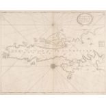
Collins (Captain Greenville). The South part of the Isles of Shetland..., circa 1720, uncoloured engraved sea chart orientated to the west, slight...
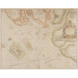
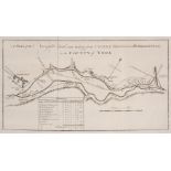
Collins (Captain Greenville). Harwich Woodbridge and Handfordwater with the Sands from the Nazeland to Hosely Bay, Yarmouth and the Sands about it...
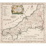
Cornwall. A collection of 16 maps and charts, 17th - 20th century, engraved regional and county maps, road maps and a 20th-century sea chart of Fa...
England & Wales. Wallis's Tour Through England and Wales, A New Geographical Pastime, London: John Wallis, 24th December 1794, engraved map with c...
Folding maps. A mixed collection of 25 maps, 18th - 20th century, engraved and lithographic foreign maps, British county maps, regional maps and t...
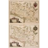
* Germany/Saxony. De Jode (Cornelis), Saxonum Regionis Quatenus eius Gentis Imperium Nomenque Antwerp, 1593, engraved map with contemporary hand c...
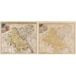
* Hampshire. Blaeu (J.), Hantonia sive Southantonensis comitatus vulgo Hant-shire, circa 1645
* Hampshire. Blaeu (Johannes), Hantonia sive Southantonensis comitatus vulgo Hant-shire, Amsterdam, circa 1645, engraved map with contemporary out...
Hertfordshire. Saxton (Christopher), Hartfordiae Comitatus nova, vera ac particularis descriptio, 1579, engraved map with contemporary outline col...
Hertfordshire. Smith (William). Hartfordiae Comitatus nova Descriptio..., sold by John Overton, printed and sold by P. Stent, circa 1670, engraved...
* Lithuania. Homann (Johann Baptist, Heirs of), Potentissimo Borussorum Regi Friderico Wilhelmo Majestate Fortitudine Clementia Augustissimo Hanec...
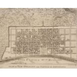
London. Visscher (Nicolas), Afbeeldinge vande Rivieren van London en Rochester, Amsterdam, 1667, uncoloured broadsheet with an engraved map with e...
Maps. A mixed collection of approximately 130 maps, 18th century, uncoloured engraved maps, approximately 40 overseas and 90 of British counties, ...
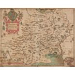
* Monmouthshire. Blaeu (Johannes), Monumethensis comitatus. Vernacule Monmouth Shire, Amsterdam, circa 1645, engraved map with contemporary hand c...
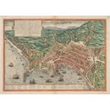
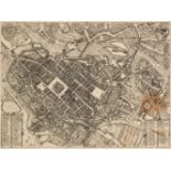
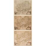
Naples. Braun (Georg & Hogenberg Franz), Haec est Nobilis, & Florens Illa Neapolis, circa 1580
Naples. Braun (Georg & Hogenberg Franz), Haec est Nobilis, & Florens Illa Neapolis, Campaniae civitas..., Cologne, circa 1580, engraved city plan ...
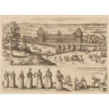
Nonsuch Palace. Braun, (Georg, and Hogenberg, Franz), Palatium Regium in Angliae Regno appellatum Nonciutz hoc est nusquam simile, circa 1582, unc...
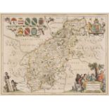
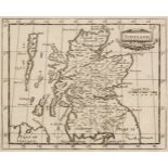
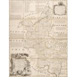
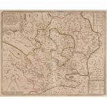
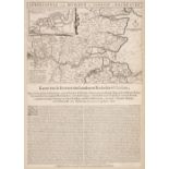
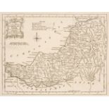
Northamptonshire. Jansson (Jan), Comitatus Northantonensis vernacule Northamto Shire, Amsterdam, circa 1650, engraved map with contemporary outlin...
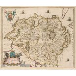
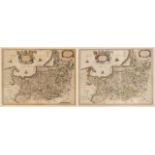
Northern Ireland. Blaeu (J.), Ultonia Hibernis Cui-Guilly; Anglis Ulster, Amsterdam circa 1645
Northern Ireland. Blaeu (Johannes), Ultonia Hibernis Cui-Guilly; Anglis Ulster, Amsterdam circa 1645, engraved map with contemporary outline colou...
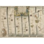
Ogilby (John). The Road from London to Aberistwith on the Sea Coast com. Cardigan Wherein are Included the Roads to Oxford and Worcester..., [and]...
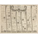
Ogilby (John). The Road from Oxford to Coventry continued to Darby, circa 1675, uncoloured engraved strip road map, slight overall toning, 340 x 4...
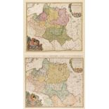
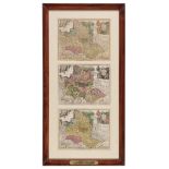
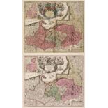
* Poland. Blaeu (Guillaume & Joan), Comitatus Glatz authore Jona Sculteto, Amsterdam, circa 1640, three engraved maps with contemporary outline co...
* Poland. Homann (Johann Baptiste, heirs of), Comitatus Glaciensis tabula..., Nuremberg, 1747, engraved map with contemporary hand colouring and s...
* Poland. Homann (Johann Baptist), Mappa Geographica Regni Poloniae ex Novissimis quot quot sunt Mappis Specialibus Composita et ad LL. Stereograp...
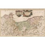
* Poland. Jaillot (Alexis-Hubert), Le Duché de Pomeranie divisé en ses Principales Parties, Paris, 1692, large engraved map with contemporary outl...
* Poland. Seutter (G.), Poloniae Regnum ut et Magni Ducat Lithuaniae..., Augsburg, circa 1750, map with contemporary hand colouring, engraved by T...
* Poland. Seutter (George Matthaus), Borussiae Regnum..., Augsburg, circa 1730, engraved map with contemporary hand colouring, inset map of the Pr...
Poland/Silesia. Blaeu (Johannes), Ducatus Silesiae Glogani vera Delineatio..., Amsterdam, circa 1640, uncoloured engraved map, slight creasing, so...
* Prussia. Blaeu (W. J.), Prussia Accurate Descripta a Gasparo Henneberg Erlichensi, circa 1645
* Prussia. Blaeu (Willem Janszoon), Prussia Accurate Descripta a Gasparo Henneberg Erlichensi, Amsterdam, circa 1645, engraved map with contempora...
* Riga/Latvia. Jansson (Jan), Riga, circa 1660, hand-coloured engraved birds-eye view of Riga, originally published in Illustriorum Principumque U...
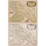
* Silesia & Moravia. Sanson (Nicolas), Provinces Unies et Incorporées a la Couronne de Boheme, qui sont les Duche de Silesie, Marqsats de Moravie ...
* Silesia. Blaeu (Willem Janszoon), Silesia Ducatus, Amsterdam, circa 1640, engraved map with contemporary hand colouring, slight toning to centra...
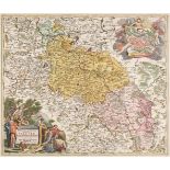
Silesia. Homann (J. B.), Superioris et Inferioris Ducatus Silesiae in suos XVII Minores Principatus et Dominia Divisi Nova Tabula..., Nuremberg, c...
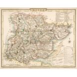
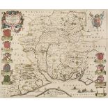
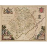
Suffolk. Speed (John), Suffolke described and divided into Hundreds, the situation of the fayre towne Ipswich shewed, with the Armes of the most n...
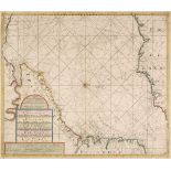
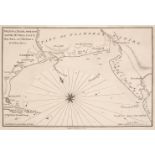
Van Keulen (Gerald). Nieuwe Zeekaart van t' Eerste Gedeelte van t' Canaal Tuischen Engeland en Vrankryk, Amsterdam, circa 1680, hand-coloured engr...
Wales. A collection of approximately 60 county maps, 17th - 19th century, engraved county maps, mostly uncoloured, including examples by Owen & Bo...
Wales. Morris (William), A collection of 17 maps of Ports & Harbours, 1800, engraved plans of ports and harbours in Wales, 12 with later hand colo...
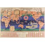
World. Jannot (J. B.), Le Tour du Monde en 120 Images Grand Concours du Chocolat Menier, Paris, 1956, colour lithographic map, three inset maps of...
Heylyn (Peter). Cosmographie ... Containing the Chorographie and Historie of the Whole World, 1669
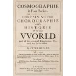
Heylyn (Peter). Cosmographie, in Four Books. Containing the Chorographie and Historie of the Whole World, and all the Principal Kingdoms, Province...
Jones (Henry). The Philosophical Transactions (From the Year 1700 to the Year 1720) Abridg'd and Dispos'd under General Heads, volume V only, 1721...
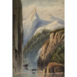
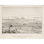
* South America. Straits of Magellan, c.1850, watercolour on laid paper, somewhat spotted above skyline, short closed tear, mid-19th-century ink i...
![Cary (John). [Cary's New and Correct English Atlas ...], circa 1787](https://portal-images.azureedge.net/auctions-2020/srdom10155/images/31325201-bb2e-483f-aca8-ac3e00c8d775.jpg?w=155&h=155)
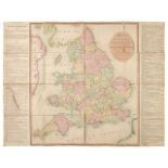
[Cary (John)]. [Cary's New and Correct English Atlas: Being a New set of County Maps from actual surveys...], circa 1787, general map of England &...
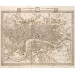
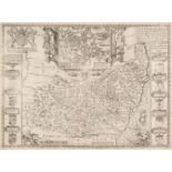
Lewis (Samuel). A Topographical Dictionary of England ..., Atlas volume only, London: S.Lewis and Co., 1831, folding engraved map of England and W...
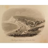
Viewbooks. 14 viewbooks for Devon & Cornwall, Isle of Wight, and Stratford on Avon, mid 19th c.
Viewbooks. 14 viewbooks including Devon & Cornwall, Isle of Wight, and Stratford on Avon, mid 19th century, comprising: 1. Devonshire, Exeter: H. ...
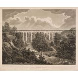
* Canals. Eginton (Francis), To the Ellesmere Canal Company this View of Pont Y Cyssyllte Aqueduct is Inscribed by their most Ob. Humble Serv. Geo...
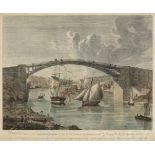
* Hunter (Henry). A South East view of the Cast Iron Bridge over the River Wear at Sunderland, 1796
* Hunter (Henry). A South East view of the Cast Iron Bridge over the River Wear at Sunderland in the Co. of Durham Built by Rowland Burdon Esqr. M...
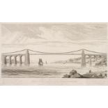
* Turrell (Edmund). View of the Suspension Bridge now erecting over the Menai Strait near Bangor in Carnarvonshire, from the Design of Thomas Telf...
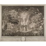
* Varin (Charles Nicolas, 1741-1812). Feu d'Artifice tiré sur la Place de la Couture a l'occasion de l'Inauguration de la Statue du Roy a Reims, 2...
* Spain. A mixed collection of 34 prints and maps, 18th & 19th century, engraved topographical views, costume, historical scenes and regional maps...