Filtered by:
- Sale Section,
- Item Type
- List
- Grid
A subscription to the Price Guide is required to view results for auctions ten days or older. Click here for more information

Barclay. (Rev. James). A Complete and Universal Dictionary of the English Language..., George Virtue, circa 1845, portrait frontispiece of Queen V...
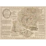
Bowen (Emanuel, the late, & Thomas). Atlas Anglicanus, or a Complete sett of Maps of the Counties of South Britain; Divided into their respective ...
Britton (John). Cathedral Antiquities. Historical and Descriptive Accounts, 5 volumes, London: M.A. Nattali, 1836, numerous engraved plates and pl...
![Cary (John). [Cary's New and Correct English Atlas ...], circa 1787](https://portal-images.azureedge.net/auctions-2020/srdom10155/images/31325201-bb2e-483f-aca8-ac3e00c8d775.jpg?w=155&h=155)
[Cary (John)]. [Cary's New and Correct English Atlas: Being a New set of County Maps from actual surveys...], circa 1787, general map of England &...
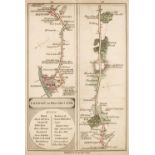
Cary (John). Cary's Survey of the High Roads from London to Hampton Court, Ware, Bagshot...wherein Every Gentleman's Seat, situate on, or seen fro...
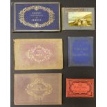
Channel Islands - Viewbooks. Four viewbooks of the Channel Islands, circa 1850s-60s, comprising: 1. Harwood's Illustrations of Jersey, circa 1855,...
Cooke (George Alexander). Topography of Great Britain: or British Traveller's Directory, 1802-1817?
Cooke (George Alexander). Topography of Great Britain: or, British Traveller's Directory, and Travelling Companion, being an accurate and comprehe...
Finden (E. & W.). The Ports, Harbours, Watering-Places, and Picturesque Scenery of Great Britain, illustrated by views taken on the spot, 2 volume...
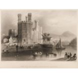
![Gastineau (Henry). Wales Illustrated [and South Wales Illustrated], in a Series of Views, circa](https://portal-images.azureedge.net/auctions-2020/srdom10155/images/ef24a9e2-f90e-411c-87e6-ac400127d46b.jpg?w=155&h=155)
Gastineau (Henry). Wales Illustrated [and South Wales Illustrated], in a Series of Views, circa
Gastineau (Henry). Wales Illustrated [and South Wales Illustrated], in a Series of Views ..., 2 volumes, London: Jones & Co., circa 1830, engraved...
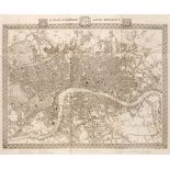
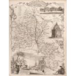
Lewis (Samuel). A Topographical Dictionary of England ..., Atlas volume only, London: S.Lewis and Co., 1831, folding engraved map of England and W...
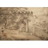
Marklove (H.). Views of Berkeley Castle, taken on the spot, and drawn on stone ..., Nailsworth: printed by William Partridge, 1840, 10 lithographi...
Moule (Thomas). The Landscape Album; or, Great Britain Illustrated, 2 volumes (1st & 2nd series), London: Charles Tilt, 1832 & 1834, 119 engraved ...
Paterson (Capt. Daniel). Paterson's British Itinerary Being a new and accurate Delineation and Description of the Direct and Principal Cross Roads...

Skelton (Joseph). Engraved Illustrations of the Principal Antiquities of Oxfordshire, from Original Drawings by F. Mackenzie ..., Oxford: J. Skelt...

Skelton (Joseph). Skelton's Engraved Illustrations of the Principal Antiquities of Oxfordshire,
Skelton (Joseph). Skelton's Engraved Illustrations of the Principal Antiquities of Oxfordshire, from Original Drawings by F. Mackenzie, Oxford: J....

Storer (James). History & Antiquities ... Cathedral Churches of Great Britain, 4 vols. in 2,
Storer (James). History and Antiquities of the Cathedral Churches of Great Britain, 4 vols. in 2, 1814-19, additional engraved titles, numerous en...
Viewbooks. 14 viewbooks for Devon & Cornwall, Isle of Wight, and Stratford on Avon, mid 19th c.
Viewbooks. 14 viewbooks including Devon & Cornwall, Isle of Wight, and Stratford on Avon, mid 19th century, comprising: 1. Devonshire, Exeter: H. ...

Viewbooks. 18 viewbooks for Lake District, Scotland, Devon & Cornwall, etc., mid 19th century
Viewbooks. 18 viewbooks for Lake District, Scotland, Devon & Cornwall, etc., mid 19th century, including: 1. Views of the English Lakes, Windermer...

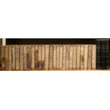
Viewbooks. 28 viewbooks for Devon, South Coast, Thames, Norfolk, Midlands, & Edinburgh, mid 19th c.
Viewbooks. 28 viewbooks for Devon, South Coast, River Thames, Norfolk, Midlands, & Edinburgh, etc., mostly mid 19th c., including: 1. Besley's Eig...

Walpoole (George Augustus). The New British Traveller; or, a Complete Modern Universal Display of Great-Britain and Ireland: being a new, complete...
Wickes (Charles). The Spires and Towers of the Medieval Churches of England, 3 volumes in 1, 1859, 72 lithographed plates, blank versos of plates ...