Filtered by:
- Category,
- Item Type
- List
- Grid
A subscription to the Price Guide is required to view results for auctions ten days or older. Click here for more information

Heylyn (Peter). Cosmographie , In Four Books. Containing the Chorography and History of the Whole World: And all the Principal Kingdoms, Provinces...
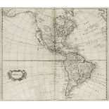
Martin (R. Montgomery). The Illustrated Atlas and Modern History of the World..., John Tallis & Company, circa 1860, decorative title page, two co...
Ashmole (Elias). The Antiquities of Berkshire, 3 volumes, London: E, Curll, 1719, folding engraved frontispiece to volume 1, folding engraved map ...
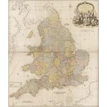
Lewis (Samuel). Atlas to the Topographical Dictionary of England comprising a General Map of England, a Plan of London and Maps of the counties......
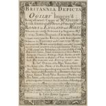
Owen (John & Bowen Emanuel). Britannia Depicta or Ogilby Improv'd; being a Correct Coppy of Mr Ogilby's Actual Survey of all ye Direct & Principal...
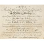
Senex (John). The Roads through England delineated or Ogilby's Survey revised, improved and reduced to a size portable for the pocket..., printed ...
Tombleson (William). [Eighty Picturesque Views on the Thames and Medway...], circa 1840, lacking title but retaining the decorative half-title and...
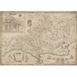
Mavor (William). General View of the Agriculture of Berkshire. Drawn up for the consideration of the Board of Agriculture and Internal Improvement...
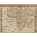
* Africa. Speed (John), Africae described, the manners of their habits and buildings newly done into English by J. S., Thomas Bassett & Richard Ch...
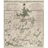
Battle of Waterloo. Hall (Sidney), An Historical Map & Plan of the Campaign in Belgium, AD 1815 exhibiting the Cantonments, Encampments, Positions...
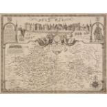
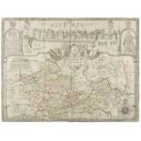
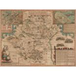
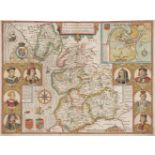
Berkshire. Speed (John), Barkshire Described, John Sudbury & George Humble, circa 1627, uncoloured engraved map, panorama of Windsor castle, centr...
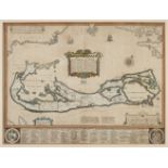
* Bermuda. Speed (John), A Mapp of the Sommer Islands once called the Bermudas, Lying at the mouth of the Bay of Mexico..., George Humble, [1627, ...
Blome (Richard). A collection of eight county maps, circa 1673, engraved maps, comprising of Monmouth, Bedfordshire, Cumberland, Huntingdonshire, ...
Bowles (John, publisher). Ogilby's Travellers Guide: or Gentleman's Pocket Companion through all the Direct and principal Cross Roads in England a...
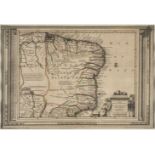
* Brazil. Van der Aa (Pieter), Le Bresil suivant les Nouvelles Observations..., Leiden, circa 1720, engraved map with contemporary outline colouri...
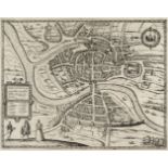
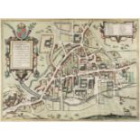
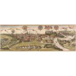
Bristol. Braun (Georg & Hogenberg Franz), Brightstowe, circa 1588, uncoloured engraved town plan, 340 x 435 mm, French text on versoQty: (1)NOTESA...
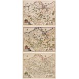
British County Maps. A collection of approximately 200 county maps, 18th & 19th century, engraved county maps, with examples by Cary, Moule, Fulla...
British County Maps. A collection of approximately 430 maps, 18th & 19th century, English and Welsh county maps and town plans, including examples...
British County Maps. A good mixed collection of approximately 75 maps, 17th - 19th century, engraved county and regional maps, including examples ...
* British Isles. Jansson (Jan & Ortelius Abraham), Insularum Britannicarum Acurata Delineatio ex Geographicis Conatibus Abrahami Ortelii, Amsterda...
British Isles. Speed (John), Britain as it was devided in the tyme of the Englishe Saxons especially during their Heptarchy, John Sudbury and Geor...
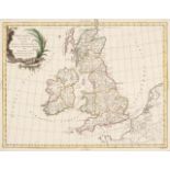
British Isles. Speed (John), The Kingdome of Great Britaine and Ireland, John Sudbury & George Humble, circa 1627, hand coloured engraved map, ins...
British Isles. Zatta (Antonio), Britannicae Insulae in quibus Albion seu Britannia Major et Ivernia seu Britannia Minor, Venice, 1785, engraved ma...
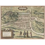
Cambridge. Braun (Georg & Hogenberg Franz), Cantebrigia opulentissimi Anglie Regni urbs celeberrimi nominsis ab Academie conditore Cantabro cognom...
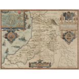
* Cardiganshire. Speed (John), Cardigan Shyre described with the due forme of the shire town as it was surveyed by J. S. Anno 1610, John Sudbury &...
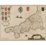
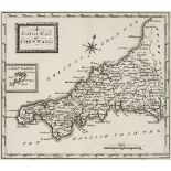
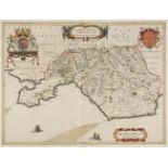
* Cornwall. Blaeu (Johannes), Cornubia sive Cornwallia, Amsterdam, circa 1645, engraved map with contemporary outline colouring, ornate strapwork ...
* Cracow. Braun (Georg & Hogenberg Franz), Cracovia Metropolis Regni Poloniae, Amsterdam, circa 1657, hand coloured large engraved city panorama o...
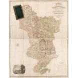
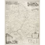
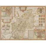
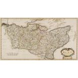
Derbyshire. Sanderson (George). This map of the County of Derby from a Careful Survey made in the years 1834 and 1835, is with the greatest respec...
Dorset. Saxton (Christopher & Lea Philip), Dorsetshire Described by C. Saxton. Corrected and Amended with many Additions as Roads &c. by P. Lea, c...
![* Dorset. Speed (John), Dorsetshyre with the Shire-towne Dorchester described [1611]](https://portal-images.azureedge.net/auctions-2020/srdom10154/images/1d1be728-0393-42e0-af00-ac1e0105295b.jpg?w=155&h=155)
* Dorset. Speed (John), Dorsetshyre with the Shire-towne Dorchester described, as also the Armes of such noble families as have bene honoured with...

* East Indies. Mercator (Gerard & Hondius Henricus), India Orientalis, [1606 or later], engraved map with contemporary outline colouring, large st...
Edinburgh. Braun (Georg & Hogenberg Franz), Edenburg - Edenburgum Scotiae Metropolis, circa 1581, engraved map with bright contemporary hand colou...
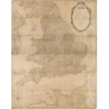
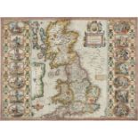
England & Wales. Carington Bowles (publisher), Bowles's New and Accurate Map of England and Wales Comprehending all the Cities, Boroughs, Market a...
England & Wales. De Vaugondy (Robert), Le Royaume D'Angleterre divisé selon les sept Royaumes ou Heptarchie de Saxons avec la Principauté de Galle...
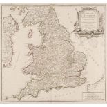
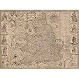
England & Wales. Kitchin (Thomas), An Accurate Map of England and Wales, Drawn from all the particular Surveys hitherto published, Illustrated wit...
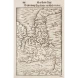
England & Wales. Munster (Sebastian), Das Ander Buch Beschrebung Engellandts und Schottlandts, [1578 or later], uncoloured woodblock map, closed t...
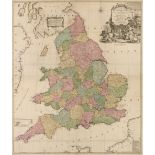
* England & Wales. Rocque (John), England and Wales drawn from the most accurate surveys containing all the Cities, Boroughs, Market Towns & Villa...
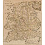
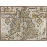
England & Wales. Speed (John), The Kingdome of England, 1st edition, John Sudbury & George Humble, 1611, uncoloured engraved 'carte-a-figure' map ...
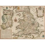
* England, Wales & Ireland. Speed (John), The Invasions of England and Ireland, with al their Civill Wars since the Conquest, Thomas Bassett & Ric...
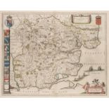
Essex. Blaeu (Johannes), Essexia comitatus, Amsterdam, Amsterdam, circa 1648, engraved map with contemporary outline colouring, decorative cartouc...
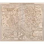
Europe. Munster (Sebastian), Europa das ein Drittheil der Erde nach gelegenheit..., circa 1588
Europe. Munster (Sebastian), Europa das ein Drittheil der Erde nach gelegenheit unserer zeit beschrieben, Basel, S. H. Petri, circa 1588, uncolour...
* Europe. Quad (Matthias), Europa, Cologne, circa 1598, engraved map with contemporary outline colouring, slight text show through, 195 x 265 mm, ...
Folding maps. A mixed collection of approximately 175 maps, 19th & 20th century, engraved and lithographic folding maps of British counties and re...
Folding Maps. A mixed collection of seventeen maps, mostly 19th century, including Nantiat (Jaspar). A New Map of Spain and Portugal Exhibiting th...
Folding maps. A mixed collection of ten folding maps, mostly 19th century, including Cruchley (G. F.). Cruchley's Improved Geographical Companion ...
* Germany. Jansson (Jan & Blaeu W. J.), Brandeburgum Marchionatus cum Ducatibus Pomeraniae et Mekelenburgi, Amsterdam, circa 1638, three engraved ...
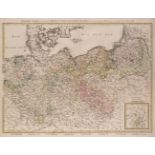
Germany. Walch (Johann, publisher), General Charte... Koniglich Preussischen Staaten..., 1797
Germany. Walch (Johann, publisher), General Charte über die sämtlich Königlich Preussischen Staaten nach astronomischen Beobachtungen, Ausburg, 17...
* Glamorganshire. Blaeu (Johannes), Glamorganensis comitatus vulgo Glamorgan Shire, circa 1648, engraved map with contemporary outline colouring, ...
* Gloucestershire. Speed (John), Glocestershire contrived into thirty thre severall hundreds & those againe into foure principall devisions. The C...
Hertfordshire. Speed (John), Hartford Shire Described. The sittuations of Hartford and the most ancient towne S Albons with such memorable actions...
Hungary. Speed (John), The Mape of Hungari newly augmented..., Thomas Bassett & Richard Chiswell, [1676], hand coloured 'carte-a-figure' map with ...
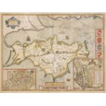
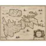
Isle of Wight. Speed (John), Wight Island, Thomas Bassett & Richard Chiswell, [1676], hand coloured engraved map, inset town plans of Newport and ...
Kent. Morden (Robert), Kent, [1695 or later], hand coloured engraved map, large strapwork cartouche, old folds, one repaired marginal closed tear,...
Kent. Speed (John), Kent with her Cities and Earles described and observed, Thomas Bassett & Richard Chiswell, 1676, hand coloured engraved map, i...
Kent. Speed (John), Kent with her Cities and Earles described and observed, Thomas Bassett & Richard Chiswell, 1676, hand coloured engraved map, i...
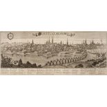
Konigsberg. Haffner (Johann Christoph, publisher), Regomontium Konigsberg, Augsburg, circa 1740, uncoloured engraved panorama, old folds, slight d...
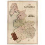
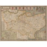
Lancashire. Hennet (G.), A Map of the County Palatine of Lancaster Divided into Hundreds and Parishes from an accurate Survey made in the years 18...
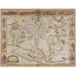
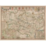
Lancashire. Speed (John), The Countie Pallatine of Lancaster described and divided into Hundreds, George Humble, circa 1627, hand coloured engrave...
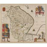
Lincolnshire. Jansson (Jan), Lincolnia Comitatus Anglis Lyncolne Shire, Amsterdam, circa 1648, engraved map with contemporary outline colouring, d...
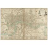
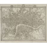
London. Bowles & Carver, (publishers), Bowles's New one-Sheet Plan of the Cities of London and Westminster with the Borough of Southwark; comprehe...