Filtered by:
- Sale Section,
- Item Type
- List
- Grid
A subscription to the Price Guide is required to view results for auctions ten days or older. Click here for more information

Barclay (Rev. James). The Universal English Dictionary containing an Explanation of Difficult Words and technical Terms..., published J. & F. Tall...
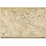
Battle of Breslau. Five engraved battle plans, circa 1757, including Schley (Jacobus van der). Bataille de Breslau Du 22. Novembre 1757..., and Pl...
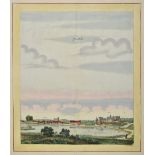
* Beek (Anna). Liebenwalde & Sonnenburch, The Hague, circa 1700, two engraved town-views with contemporary hand colouring of Sonnenburg near Küstr...
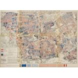
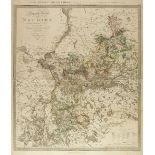
Booth (Charles). Descriptive Map of East End Poverty, Compiled from School Board Reports' in 1887, 1st edition, [Macmillan & Co., 1889], lithograp...
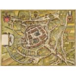
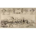
Braun (Georg & Hogenberg Franz). Die Stat Swybuschin in nider Schlesien, 1598, engraved town plan with contemporary hand colouring, slight margina...
British Isles. A mixed collection of nineteen country, regional, road and county maps, 16th - 19th century, engraved maps, including examples by S...
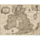
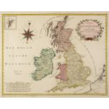
* British Isles. De Vaugondy (Robert), Les Isles Britanniques qui comprennent les Royaumes D'Angleterre, D'Ecosse et D'Irlande, Paris, 1754, engra...
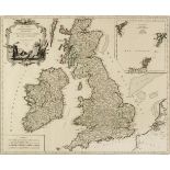
British Isles. Merian ( Matthaus ), Magnae Britanniae et Hiberniae tabulae die Britannischen Insulen, circa 1646, uncoloured engraved map, inset m...
British Isles. Von Reilly (Franz Johann Joseph), Karte von Gross Britannien und Ireland..., 1795
British Isles. Von Reilly (Franz Johann Joseph), Karte von Gross Britannien und Ireland. Nach Kitchin, Dorret und Jefferys.., 1795, engraved map w...
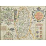
* Cambridgeshire. Speed (John), Cambridgshire described with the devision of the hundreds, the townes situation with the Armes of the Colleges of ...
Universal Magazine. A group of seven maps and plans of Canada, North America and elswhere, taken from the Universal Magazine, 1750s, including A P...
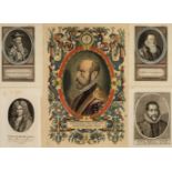
* Cartographers. A collection of thirteen portraits of cartographers, 16th - 19th century, including Galle (Philip). Spectandum dedit Ortelius mor...
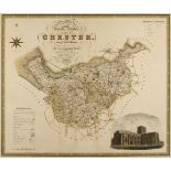
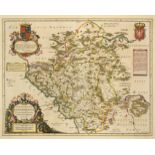
* Cheshire. Blaeu (Johannes), Cestria comitatus Palatinus, Amsterdam, circa 1645, engraved map with contemporary hand colouring, decorative cartou...
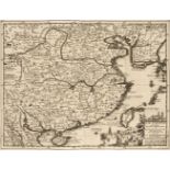
China. Van der Aa (Pieter), la Chine Suivant les Nouvelles Observations..., Leiden, circa 1720
China. Van der Aa ( Pieter ), la Chine Suivant les Nouvelles Observations..., Leiden, circa 1720, uncoloured engraved map with decorative cartouch...
Danzig. Wening (Michael), Dantzig eine vornehme Handelstatt im Koniglichen Preusseri, circa 1670
Danzig/Gdansk. Wening (Michael), Dantzig eine vornehme Handelstatt im Koniglichen Preusseri, Nuremberg, circa 1670, uncoloured engraved view of Gd...
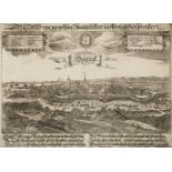
* Danzig/Gdansk . Hartnoch (Christoph), Danzig, circa 1684, hand coloured engraved panorama decorated with two coats of arms and a key table listi...
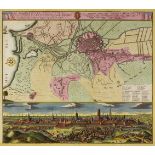
Danzig/Gdansk Homann (Johann Baptist, heirs of), Die Konigl. Polnische u Preusische Hansee - und Handels-Stadt Dantzig, Poln. Gdansko im Lande Pom...
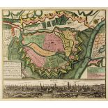
Danzig/Gdansk. Lotter (Conrad Tobias), Plan der Stadt und Gegend von Dantzig nebst dem Ausslus der Weichsel, Augsburg, 1784, engraved map of the e...
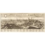
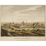
* Danzig/Gdansk. Rupprecht (Marc Abraham), Dantiscum, Danzig, Augsburg, circa 1750, uncoloured engraved panorama, identification key in Latin and ...
Danzig/Gdansk. Seutter (Mattheus), Dantiscum f Gedanum celeberrimum, spatiosum et munitum Emporium ac Hanseatica Civitas ad Ostia Vistuale in Plon...
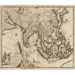
East Indies. Van der Aa ( Pieter ), Les Indes Orientales suivant les Nouvelles Observations..., circa 1720, uncoloured engraved map,decorative car...
Eastern Europe. De Vaugondy (Robert), Partie Septentrionale du Cercle de Haute Saxe..., circa 1784
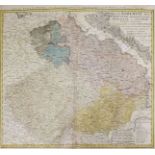
Eastern Europe. De Vaugondy (Robert), Partie Septentrionale du Cercle de Haute Saxe qui contient Le Duché de Poméranie et le Marquisat de Brandebo...
Eastern Europe. Mercator (Gerard & Hondius Henricus ), Russia cum Confinijs circa 1610, hand coloured engraved miniature map, near contemporary ma...
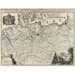
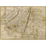
* Eastern Europe. Moll (H.), ..., This map of Moscovy, Poland, Tartary and ye Black Sea, circa 1730
* Eastern Europe. Moll (Herman), To His Most Serene and August Majesty Peter Alexovitz Absolute Lord of Russia &c. This Map of Moscovy, Poland, Ta...
* Eastern Europe. Munster (Sebastian), Landtafel des Ungerlands, Polands, Reussen, Littaw, Walachen und Bulgaren, [1550 and 1588], woodblock map w...
English Channel. Seutter (Matthäus), La plus grande partie de la Manche, qui contient les côtes D'Angleterre et celles de France, les Bords Mariti...
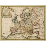
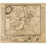
Europe. Van de Aa (Pieter), L'Europe suivant les Nouvelles Observations..., Leiden, circa 1714,
Europe. Van de Aa (Pieter), L'Europe suivant les Nouvelles Observations..., Leiden, circa 1714, hand coloured engraved map, slight staining and cr...
Galicia. Probst (Jean Michael), Carte nouvelle des Royaumes de Galizie et Lodomerie..., circa 1780
Galicia. Probst (Jean Michael), Carte nouvelle des Royaumes de Galizie et Lodomerie avec le District de Bukowine, Augsburg, circa 1780, engraved m...
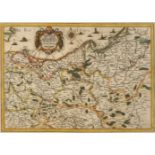
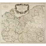
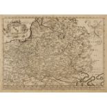
* Germany & Poland. Berey (Nicolas & Tassin Christopher, publishers), Carte des Duches de Saxe Meklembourg, Pomeranie, Prusse et Marquisat de Bran...
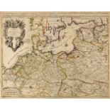
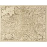
Germany & Poland. Sanson (N.), Téatre de la Guerre des Couronnes du Nord, publsihed Pierre Mortier, Amsterdam, circa 1690, engraved map, engraved ...
Germany/Prussia. Halma (Francois), Regni Borussiae et Electoratus Brandeburgici.., circa 1700
Germany/Prussia. Halma (Francois), Regni Borussiae et Electoratus Brandeburgici, Ceterarumque, Quae Friderici, Regis Boruss. sceptro reguntur, nec...
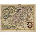
* Gloucestershire. Speed (John), Glocestershire contrived thirty thre severall hundreds and those againe into foure principall devisions. The citi...
Greenwood (C. & J.). A collection of eleven county maps, circa 1830, engraved maps, eight with contemporary hand colouring, some toning and staini...
![Hevelius (Johannes). Cepheus, published Dantzig, [1687],](https://portal-images.azureedge.net/auctions-2020/srdom10149/images/c086aa4e-ca23-443c-b3eb-abd600c66f98.jpg?w=155&h=155)
Hevelius (Johannes). Cepheus, published Dantzig, [1687], hand coloured engraved constellation map originally published in 'Firmamentum Sobiescianu...
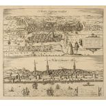
Konigsberg & Riga. Braun (Georg & Hogenberg Franz), Die Furtsliche Hauptt Statt Konigssberk...,
Königsberg [and] Riga. Braun (Georg & Hogenberg Franz), Die Furtsliche Hauptt Statt Konigssberk in Preussen [and] Riga percommode ad Duna Amnem Si...
Latvia; Riga. Aveline (Antoine), Profil de la ville de Riga capitale de province de Livonie..., Paris, circa 1710, engraved panorama of Riga with ...
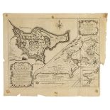
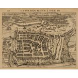
Lubin/Poland. Covens (Johannes & Mortier Cornelius), Lublin, Amsterdam, [1721], uncoloured engraved city plan with key plate below the image, 305 ...
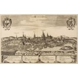
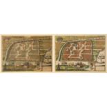
Lviv/Ukraine. Braun (Georg & Hogenberg Franz), Leopolis Russuae Australis Urbs..., circa 1618
Lviv/Ukraine. Braun (Georg & Hogenberg Franz), Leopolis Russuae Australis Urbs primaria emporium mercium Orientalium celeberrimum, Cologne, circa ...
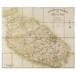
Malta. Woodward (Captain E. M., surveyor), Map of the Island of Malta, London: Intelligence Division, The War office, circa 1895, colour lithograp...
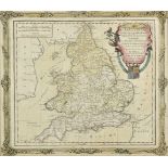
* Maps and prints. A collection of six engraved maps and prints, mostly 19th century, including Brion de la Tour (Louis). L'Angleterre divisée en ...
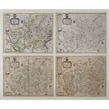
Maps. A mixed collection of approximately 100 maps, 18th & 19th century, engraved and lithographic British and foreign maps, including examples by...
Maps. A mixed collection of approximately ninety maps of British counties and regions, mostly 19th century, engraved maps of British counties and ...
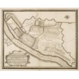
Marienburg/Malbork, Northern Poland. Von Pufendorf (Samuel Baron), ...,Marienburgensis..., 1696
Marienburg/Malbork , Northern Poland. Von Pufendorf (Samuel Baron), Delineatio Geometrica Arcis et Civitatis Marienburgensis in Bolrussia..., Nure...
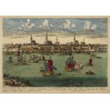
* Moscow. (Braun ( Georg, & Hogenberg, Franz), Moscauw, Moscovia, Urbs regionis eiusde nominis metropolitica, duplo maior, circa 1575, engraved ci...
Northern Europe. Lange (Johann Elias), Neue Karte den gegenwartigen Kriegs-Schauplatze..., 1788
Northern Europe. Lange (Johann Elias), Neue Karte den gegenwartigen Kriegs-Schauplatze zwischen den Russisch. Kayserl: und Königl: Schwedischen Ar...
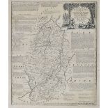
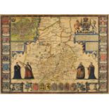
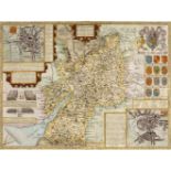
* Nottinghamshire. Speed (John), The Countie of Nottingham described, the Shire Townes situation and the Earls there of observed, John Sudbury & G...
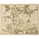
Nowa Marchia/Poland. Sotzmann (D. F.), Special Karte von der Neumark..., published Simon Schropp & Comp, Berlin, 1811, engraved map with contempor...
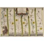
Ogilby (John). The Road from London to Newhaven com Sussex..., continued from Newhaven to New Shoreham com Sussex, circa 1680, hand coloured engra...
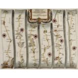
Ogilby (John). The Road from London to St Davids in com. Pembroke, circa 1675, hand coloured engraved strip road map, 305 x 450 mm, mounted (Qty: ...
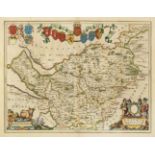
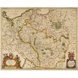
* Poland. Allard (Hugo), Nova Totius Regni Poloniae, Magniq. Ducatus Lithuaniae, cum suis Palatinatibus ac Confinis, published Amsterdam by Guilla...
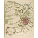
Poland. Bertius (Petrus), Stettin, circa 1632, uncoloured engraved town plan, originally published in 'Commentariorum rerum Germanicarum libri tre...
Poland. Blaeu (J.), Ducatus Oswieczensis et Zatoriensis, Amsterdam circa 1670, engraved map of Southern Poland with bright contemporary hand colou...
Poland. Blaeu (Johannes), Palatinatus Posnaniensis, in Maiori Polonia Primarii..., circa 1670
Poland. Blaeu (Johannes), Palatinatus Posnaniensis, in Maiori Polonia Primarii nova delineatio. per G. F. M. Amsterdam, circa 1670, engraved map w...
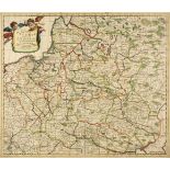
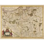
Poland. Blome (Richard), A Mapp of the Estates of the Crowne of Poland, where are the Kingdom of Poland withits Palatinates, the Dutches of Russia...
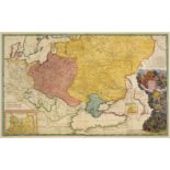
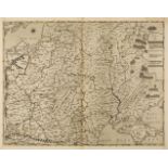
Poland. Danckerts (Justus), Regni Poloniae et Ducatus Lithuaniae, Voliniae, Podoliae, Ucraniae, Prussiae et Curlandiae..., Amsterdam circa 1700, e...
Poland. De L'Isle (Guillaume), La Pologne Dressée sur ce qu'en ont donné Starovolsk, Beauplan, Hartnoch et autres..., Paris, 1703, engraved map wi...
Poland. Gastaldi (Giacomo), Il vero disegno della seconda parte dil Regno di Polonia, Venice, 1568, uncoloured map, engraved by Paolo Forlani, tri...
Poland. Jansson (Jan), Novissima Poloniae Regni Descriptio , Amsterdam, circa 1660, engraved map with contemporary outline colouring, trimmed to n...
Poland. Jansson (Jan), Poloniae nova et Acurata descriptio, published Amsterdam, circa 1638, engraved map with contemporary outline colouring, sli...
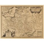
* Poland. Jansson (Jan), Silesia Inferior..., Amsterdam, circa 1647, engraved map after J. Scultetus, contemporary hand colouring, 420 x 510 mm, w...