Refine your search
Sale Section
Remove filter- Maps and Charts (78)
Estimate
Category
Filtered by:
- Lots with images only,
- Sale Section,
- Item Type
- List
- Grid
A subscription to the Price Guide is required to view results for auctions ten days or older. Click here for more information
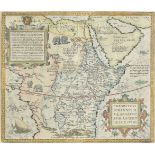

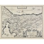
*Africa. Ortelius (Abraham), Presbiteri Johannis sive Abissinorum Imperii descriptio, [1573 or
*Africa. Ortelius (Abraham), Presbiteri Johannis sive Abissinorum Imperii descriptio, [1573 or later], engraved map with contemporary hand colouri...
![Africa. Ortelius (Abraham), Africae tabula nova, [1570 or later], hand coloured engraved map,](https://portal-images.azureedge.net/auctions-2019/srdom10124/images/c9d2e672-b6ce-4db2-9735-a9fc00e15284.jpg?w=155&h=155)
Africa. Ortelius (Abraham), Africae tabula nova, [1570 or later], hand coloured engraved map,
Africa. Ortelius (Abraham), Africae tabula nova, [1570 or later], hand coloured engraved map, large strapwork cartouche, slight soiling to margins...
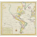
Americas. Tirion (Isaak), Nieuwe Kaart Van het Westelykste Deel Der Weereld, dienende tot aanwyzing an de Scheepstogten der Nederlanderen Naar Wes...
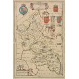
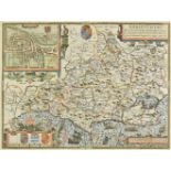
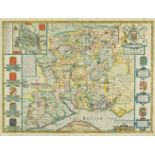
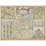
Bedfordshire. Speed (John), Bedford Shire and the situation of Bedford described with the armes of
Bedfordshire. Speed (John), Bedford Shire and the situation of Bedford described with the armes of those honorable familyes that have borne ye tit...
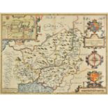
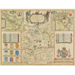
![Berkshire. Speed (John), Barkshire described, [1616], uncoloured engraved map, panorama of Windsor](https://portal-images.azureedge.net/auctions-2019/srdom10124/images/5470f5b3-19ab-4a39-9f38-a9fc00e15400.jpg?w=155&h=155)
Berkshire. Speed (John), Barkshire described, [1616], uncoloured engraved map, panorama of Windsor
Berkshire. Speed (John), Barkshire described, [1616], uncoloured engraved map, panorama of Windsor castle, 385 x 510 mm, Latin text on verso A goo...
![*Berkshire. Speed (John), Barkshire described, [1616], hand coloured engraved map, panorama of](https://portal-images.azureedge.net/auctions-2019/srdom10124/images/54280518-e6b7-4a78-9d2f-a9fc00e1547e.jpg?w=155&h=155)
*Berkshire. Speed (John), Barkshire described, [1616], hand coloured engraved map, panorama of
*Berkshire. Speed (John), Barkshire described, [1616], hand coloured engraved map, panorama of Windsor castle, central fold partially strengthened...
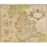
Bradshaw (George, publisher). G.Bradshaw's Map of Canals Situated in the Counties of Lancaster,
Bradshaw (George, publisher). G.Bradshaw's Map of Canals Situated in the Counties of Lancaster, York, Derby & Chester; Shewing the Heights of thei...
British county maps. A mixed collection of twenty-three county and regional maps, 17th - 19th
British county maps. A mixed collection of twenty-three county and regional maps, 17th - 19th century, engraved maps, many with hand colouring, in...
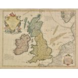
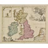
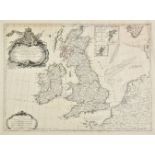
British Isles. De L'Isle (Guillaume), Les Isles Britanniques ou sont le Rme. d'Angleterre tir‚ de
British Isles. De L'Isle (Guillaume), Les Isles Britanniques ou sont le Rme. d'Angleterre tir‚ de Sped celut d'Ecosse tir‚ de Th. Pont &c. et celu...
![British Isles. Ruscelli (Girolamo), Tabula Europae I, [1561], uncoloured engraved map on a](https://portal-images.azureedge.net/auctions-2019/srdom10124/images/68692023-3e67-4876-8970-a9fc00e1568f.jpg?w=155&h=155)
British Isles. Ruscelli (Girolamo), Tabula Europae I, [1561], uncoloured engraved map on a trapezoidal projection, slight browning to central fold...
British Isles. Van der Aa (Pieter), L'Angleterre suivant nouvelles observations..., circa 1720, hand
British Isles. Van der Aa (Pieter), L'Angleterre suivant nouvelles observations..., circa 1720, hand coloured engraved map, 225 x 300 mm, together...
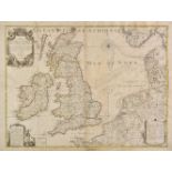
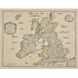
British Isles. Inselin (Charles), Carte des Royaumes d'Angleterre d'Ecosse et d'Irlande avec Les
British Isles. Inselin (Charles), Carte des Royaumes d'Angleterre d'Ecosse et d'Irlande avec Les Costes Maritimes de France, Pais-Bas, d'Allemagne...
British Isles. Jaillot (Alexis Hubert), Les Isles Britannique qui contiennent les Royaumes d'
British Isles. Jaillot (Alexis Hubert), Les Isles Britannique qui contiennent les Royaumes d'Angleterre, Ecosse et Irlande distingu‚s enleurs prin...
British Isles. Jaillot (Alexis Hubert), Carte Generale des Royaumes D'Angleterre, Escosse et
British Isles. Jaillot (Alexis Hubert), Carte Generale des Royaumes D'Angleterre, Escosse et Irlande. Avecq les Isles circonuoisines, Coniies tout...
![British Isles. Ortelius (Abraham), Britannicarum Insularum typus, [1601], uncoloured engraved map](https://portal-images.azureedge.net/auctions-2019/srdom10124/images/e5d2c2c7-4b2d-4bf9-856c-a9fc00e1592f.jpg?w=155&h=155)
British Isles. Ortelius (Abraham), Britannicarum Insularum typus, [1601], uncoloured engraved map
British Isles. Ortelius (Abraham), Britannicarum Insularum typus, [1601], uncoloured engraved map orientated to the west, large strapwork cartouch...
British Isles. Smith (Charles), Smith's new map of the navigable canals and rivers of England, Wales
British Isles. Smith (Charles), Smith's new map of the navigable canals and rivers of England, Wales & Scotland, distinctly shewing the length of ...
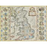
*British Isles. Speed (John), Britain as it was devided in the tyme of the Englishe Saxons especially during their Heptarchy, published John Sudbu...
British Isles. Janvier (Jean), Les Isles Britanniques Comprenant les Royaumes D'Angleterre, D'Ecosse
British Isles. Janvier (Jean), Les Isles Britanniques Comprenant les Royaumes D'Angleterre, D'Ecosse et D'Irlande, Divis‚s en Grandes Provinces, S...
Buckinghamshire. Blaeu (Johannes), Buckinghamiensis comitatus Anglis Buckinghamshire, Amsterdam,
Buckinghamshire. Blaeu (Johannes), Buckinghamiensis comitatus Anglis Buckinghamshire, Amsterdam, circa 1648, engraved map with contemporary outlin...
*Carmarthenshire. Speed (John), Caermarden both shyre and towne described, 1st. edition, published
*Carmarthenshire. Speed (John), Caermarden both shyre and towne described, 1st. edition, published John Sudbury & George Humble, [1611], hand colo...
Cheshire. Saxton (Christopher & Hole G.), Cestriae comitatus Romanis legionibus et coloniis olim
Cheshire. Saxton (Christopher & Hole G.), Cestriae comitatus Romanis legionibus et coloniis olim insignis vera et absoluta descriptio, [1607], han...
*Cheshire. Drayton (Michael), Untitled map of Cheshire, circa 1612, hand coloured engraved allegorical map, 255 x 320 mm, mounted, framed and glaz...
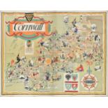
Cornwall. Cornwall, published by British Railways (Western Region), printed N. Lloyd & Co. Ltd.
Cornwall. Cornwall, published by British Railways (Western Region), printed N. Lloyd & Co. Ltd. circa 1950, large decorative and pictorial colour ...
![*Cornwall. Speed (John), Cornwall, 1st edition, published John Sudbury & George Humble, [1611], hand](https://portal-images.azureedge.net/auctions-2019/srdom10124/images/63598063-f41c-48b2-beb6-a9fc00e15e95.jpg?w=155&h=155)
*Cornwall. Speed (John), Cornwall, 1st edition, published John Sudbury & George Humble, [1611], hand
*Cornwall. Speed (John), Cornwall, 1st edition, published John Sudbury & George Humble, [1611], hand coloured engraved map, inset view of Launcest...
Cumberland. Speed (John), Cumberland and the ancient citie Carlile described with many memorable
Cumberland. Speed (John), Cumberland and the ancient citie Carlile described with many memorable antiquities therein found observed, published J. ...
Depping (G.B.). L'Angleterre ou description historique et topographique du Royaume Uni de la
Depping (G.B.). L'Angleterre ou description historique et topographique du Royaume Uni de la Grande-Bretagne, 2nd edition, volume 3 (only), Paris,...
*Dorset. Speed (John), Dorsetshyre with the shyre-towne Dorchester described as also the armes of
*Dorset. Speed (John), Dorsetshyre with the shyre-towne Dorchester described as also the armes of such noble families as have bene honored with th...
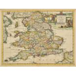
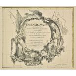
England & Wales. Jaillot (Alexis-Hubert & Sanson Nicolas), Le Royaume d'Angleterre distingu‚ en
England & Wales. Jaillot (Alexis-Hubert & Sanson Nicolas), Le Royaume d'Angleterre distingu‚ en ses provinces..., Paris, [1693], large engraved ma...
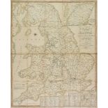
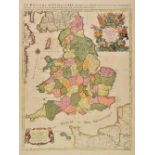
England & Wales. Delarochette (Louis Stanislas D'Arcy & Kitchin Thomas), England and Wales laid down
England & Wales. Delarochette (Louis Stanislas D'Arcy & Kitchin Thomas), England and Wales laid down from all the surveys of particular counties h...
*Essex. Speed (John), Essex devided into Hundreds with the most antient and fayre towne Colchester
*Essex. Speed (John), Essex devided into Hundreds with the most antient and fayre towne Colchester described amd other memorable monuments observe...
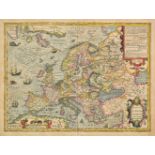
Europe. Hondius (Jodocus), Nova Europae descriptio auctore Iodoco Hondio, circa 1630, engraved map
Europe. Hondius (Jodocus), Nova Europae descriptio auctore Iodoco Hondio, circa 1630, engraved map with contemporary hand colouring, central fold ...
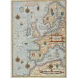
Europe. Waghenaer (Lucas Janszoon), Universe Europe Maritime Eiusque Navigationis Descriptio.
Europe. Waghenaer (Lucas Janszoon), Universe Europe Maritime Eiusque Navigationis Descriptio. Generale Paschaerte van Europa..., [1583 or slightly...
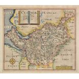
![*Flintshire. Speed (John), Flint-Shire, published Thomas Bassett & Richard Chiswell, [1676], hand](https://portal-images.azureedge.net/auctions-2019/srdom10124/images/fd6b5e4b-724d-4e65-b55d-a9fc00e162fc.jpg?w=155&h=155)
*Flintshire. Speed (John), Flint-Shire, published Thomas Bassett & Richard Chiswell, [1676], hand
*Flintshire. Speed (John), Flint-Shire, published Thomas Bassett & Richard Chiswell, [1676], hand coloured engraved map, inset town views of Flint...
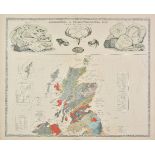
Geological Maps. Johnston (A. K.), Geological & Palaeontological Map of the British Islands,
Geological Maps. Johnston (A. K.), Geological & Palaeontological Map of the British Islands, published William Blackwood and Sons, 1st March 1854,...
*Glamorganshire. Speed (John), Glamorgan Shyre with the sittuations of the cheife towne Cardyff
*Glamorganshire. Speed (John), Glamorgan Shyre with the sittuations of the cheife towne Cardyff and ancient Landaffe described, 1st edition, publi...
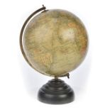
*Globe. Geographia Ltd. (manufacturer), "Geographia" 10 inch Terrestrial Globe, circa 1949, ten inch
*Globe. Geographia Ltd. (manufacturer), "Geographia" 10 inch Terrestrial Globe, circa 1949, ten inch table globe with twelve colour printed gores,...
*Hampshire. Speed (John), Hantshire described and devided, published Thomas Bassett & Richard
*Hampshire. Speed (John), Hantshire described and devided, published Thomas Bassett & Richard Chiswell, [1676], hand coloured engraved map, inset ...
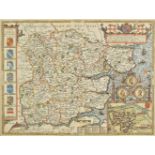
Hertfordshire. Blaeu (Johannis), Hertfordia comitatus vernacule Hertfordshire, Amsterdam, circa
Hertfordshire. Blaeu (Johannis), Hertfordia comitatus vernacule Hertfordshire, Amsterdam, circa 1648, engraved map with contemporary hand colourin...
Hertfordshire. A collection of eleven maps, mostly 18th & 19th century, engraved maps, including
Hertfordshire. A collection of eleven maps, mostly 18th & 19th century, engraved maps, including examples by Norden, Moule, Cary, Seller/Grose, Ba...
Holy Land. Blaeu (Willem Jans Zoon), Terra Sancta quae in sacris Terra Promissionis olim Palestina, Amsterdam 1629 [or later], uncoloured engraved...
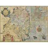
Huntingdonshire. Speed (John), Huntington both shire and shire towne with the ancient citie Ely
Huntingdonshire. Speed (John), Huntington both shire and shire towne with the ancient citie Ely described, published Thomas Bassett & Richard Chis...
*Huntingdonshire. Speed (John), Huntington both shire and shire towne with the ancient citie Ely
*Huntingdonshire. Speed (John), Huntington both shire and shire towne with the ancient citie Ely described, 1st edition, published George Humble, ...
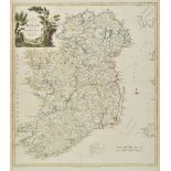
Ireland. Kitchin (Thomas), A new map of Ireland divided into provinces, counties &c., published R.
Ireland. Kitchin (Thomas), A new map of Ireland divided into provinces, counties &c., published R. Sayer & J. Bennett, 1777, engraved map with con...
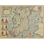
*Ireland. Speed (John), The Kingdome of Irland, devided into severall provinces and then againe into
*Ireland. Speed (John), The Kingdome of Irland, devided into severall provinces and then againe into counties newly described, 1st edition, publis...
*Ireland. Speed (John), The Province of Mounster, 1st edition, published John Sudbury & George
*Ireland. Speed (John), The Province of Mounster, 1st edition, published John Sudbury & George Humble, [1611], hand coloured engraved map, inset t...
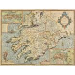
*Ireland. Speed (John), The Countie of Leinster with the citie Dublin described, published John
*Ireland. Speed (John), The Countie of Leinster with the citie Dublin described, published John Sudbury & George Humble, [1611 or later], hand col...
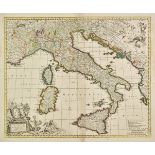
Italy. Visscher (Nicolas), Totius Italiae tabula..., circa 1715, engraved map with contemporary
Italy. Visscher (Nicolas), Totius Italiae tabula..., circa 1715, engraved map with contemporary outline colouring, separate ornamental title and d...
*Lancashire. Saxton (Christopher), Lancastriae comitatus palatin vera et absoluta descriptio,
*Lancashire. Saxton (Christopher), Lancastriae comitatus palatin vera et absoluta descriptio, circa 1579, engraved map with contemporary hand colo...
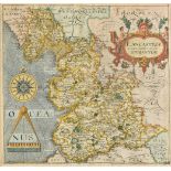
*Lancashire. Saxton (Christopher & Hole G.), Lancastriae comitatus palatinus olim pars Brigantum,
*Lancashire. Saxton (Christopher & Hole G.), Lancastriae comitatus palatinus olim pars Brigantum, 1st edition, [1607], hand coloured engraved map,...
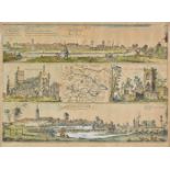
Leeds. Lodge (W. & Thorsby Ralph), The prospects of the two most remarkable towns in the North of
Leeds. Lodge (W. & Thorsby Ralph), The prospects of the two most remarkable towns in the North of England for the clothing trade, viz Leeds as it ...
*Leicestershire. Speed (John), Leicester both countye and Citie described, The Honorable famylies
*Leicestershire. Speed (John), Leicester both countye and Citie described, The Honorable famylies that have had the titles of Earls thereof. With ...
London. Bowles & Carver. Bowles's One-Sheet Plan of the Cities of London and Westminster with the
London. Bowles & Carver. Bowles's One-Sheet Plan of the Cities of London and Westminster with the Borough of Southwark; comprehending their Outski...
Maps. A mixed collection of approximately seventy-five maps and charts, mostly 18th & 19th century, engraved maps and sea charts, including exampl...
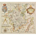
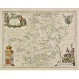
*Mercator (Gerard, and Hondius, Jodocus). Cornubia, Devonia, Somersetus, Dorcestria, Wiltonia,
*Mercator (Gerard, and Hondius, Jodocus). Cornubia, Devonia, Somersetus, Dorcestria, Wiltonia, Glocestria..., Warwicum, Northamtonia, Huntingdonia...
*Middlesex & Hertfordshire. Schenk (Pieter & Valk Gerard), Middelsexiae cum Hertfordiae comitatu
*Middlesex & Hertfordshire. Schenk (Pieter & Valk Gerard), Middelsexiae cum Hertfordiae comitatu Midlesex & Hertfordshire, Amsterdam, circa 1700, ...
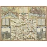
*Middlesex. Speed (John & Norden John), Midle-sex described with the most famous cities of London
*Middlesex. Speed (John & Norden John), Midle-sex described with the most famous cities of London and Westminster, 1st edition, published George H...
*Monmouthshire. Speed (John), The countye of Monmouth with the sittuation of the shire-towne
*Monmouthshire. Speed (John), The countye of Monmouth with the sittuation of the shire-towne described, 1st edition, published John Sudbury & Geor...
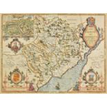
*Montgomeryshire & Merioneth. Saxton (Christopher), Montgomeri ac Merionidh duorum borialis Cambriae
*Montgomeryshire & Merioneth. Saxton (Christopher), Montgomeri ac Merionidh duorum borialis Cambriae comitatuum B. Gwinedhia A. North Wales nuneup...
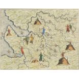
![Morocco. Ortelius (Abraham), Fessae et Marocchi regna Africae celeberr describebat, [1606], hand](https://portal-images.azureedge.net/auctions-2019/srdom10124/images/a0ba1270-094f-449c-beec-a9fc00e170a6.jpg?w=155&h=155)
Morocco. Ortelius (Abraham), Fessae et Marocchi regna Africae celeberr describebat, [1606], hand
Morocco. Ortelius (Abraham), Fessae et Marocchi regna Africae celeberr describebat, [1606], hand coloured engraved map, inset map of the Congo, la...
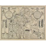
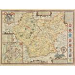
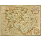
North East England. Saxton (Christopher & Hole G.), Eboracensis comitatus..., vulgo East Riding,
North East England. Saxton (Christopher & Hole G.), Eboracensis comitatus..., vulgo East Riding, Eboracensis comitatus pars Septentrionalis vulgo ...