Refine your search
Sale Section
- Antiquarian (32)
- Antique Livestock and Agricultural Prints (26)
- Decorative Prints and Original Art (38)
- Film and Theatre Memorabilia (28)
- Film Posters (23)
- Football Programmes and Sporting Books (8)
- Foreign Travel and British Topography (23)
- General Literature and Reference (26)
- General Stock (60)
- Historical Documents and Autographs (26)
- Maps and Charts (108)
- Natural History (21)
- The Ladwell Collection of Fine Bird Books: Part I (73)
- Watercolour Views of Egypt (7)
Estimate
Category
- Books & Periodicals (244)
- Maps (104)
- Prints (75)
- Entertainment Memorabilia (27)
- Watercolours (19)
- Sporting Memorabilia & Equipment (10)
- Collectables (5)
- Musical Instruments & Memorabilia (4)
- Drawings & Pastels (3)
- Photographs (2)
- Arms, Armour & Militaria (1)
- Classic Cars, Motorcycles & Automobilia (1)
- Furniture (1)
- Islamic Works of Art (1)
- Models, Toys, Dolls & Games (1)
- Sculpture (1)
- Tools (1)
Filtered by:
- Creator / Brand
- List
- Grid
A subscription to the Price Guide is required to view results for auctions ten days or older. Click here for more information

England & Wales. Moll (Herman), The South part of Great Britain called England and Wales..., sold by
England & Wales. Moll (Herman), The South part of Great Britain called England and Wales..., sold by J. & T. Bowles, Philip Overton and John King,...
England & Wales. Walker (J & C), England & Wales founded upon the grand trigonometrical survey.
England & Wales. Walker (J & C), England & Wales founded upon the grand trigonometrical survey. shewing all the Mail Coach, Turnpike & Rail Roads,...
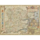
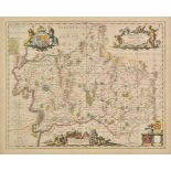
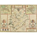
*Essex. Speed (John), Essex devided into Hundreds with the most antient and fayre towne Colchester
*Essex. Speed (John), Essex devided into Hundreds with the most antient and fayre towne Colchester described amd other memorable monuments observe...
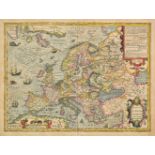
Europe. Hondius (Jodocus), Nova Europae descriptio auctore Iodoco Hondio, circa 1630, engraved map
Europe. Hondius (Jodocus), Nova Europae descriptio auctore Iodoco Hondio, circa 1630, engraved map with contemporary hand colouring, central fold ...
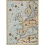
Europe. Waghenaer (Lucas Janszoon), Universe Europe Maritime Eiusque Navigationis Descriptio.
Europe. Waghenaer (Lucas Janszoon), Universe Europe Maritime Eiusque Navigationis Descriptio. Generale Paschaerte van Europa..., [1583 or slightly...
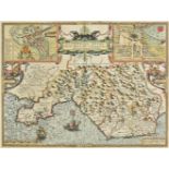
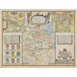
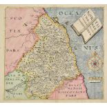
![*Flintshire. Speed (John), Flint-Shire, published Thomas Bassett & Richard Chiswell, [1676], hand](https://portal-images.azureedge.net/auctions-2019/srdom10124/images/fd6b5e4b-724d-4e65-b55d-a9fc00e162fc.jpg?w=155&h=155)
*Flintshire. Speed (John), Flint-Shire, published Thomas Bassett & Richard Chiswell, [1676], hand
*Flintshire. Speed (John), Flint-Shire, published Thomas Bassett & Richard Chiswell, [1676], hand coloured engraved map, inset town views of Flint...
Folding maps. A mixed collection of twenty-two folding maps and plans, mostly 19th century, British and foreign maps, town plans, geographical gam...
France. Ortelius (Abraham), Picardiae Belgicae regionis descriptio, [1602], hand coloured engraved
France. Ortelius (Abraham), Picardiae Belgicae regionis descriptio, [1602], hand coloured engraved map, large strapwork cartouche and mileage scal...
Geological Maps. Johnston (A. K.), Geological & Palaeontological Map of the British Islands,
Geological Maps. Johnston (A. K.), Geological & Palaeontological Map of the British Islands, published William Blackwood and Sons, 1st March 1854,...
*Germany. Mercator (Gerard), Saxonia inferior et Meklenborg DVC, circa 1607, engraved map with
*Germany. Mercator (Gerard), Saxonia inferior et Meklenborg DVC, circa 1607, engraved map with contemporary hand colouring, 345 x 450 mm, mounted,...
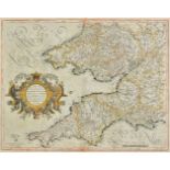
*Glamorganshire. Speed (John), Glamorgan Shyre with the sittuations of the cheife towne Cardyff
*Glamorganshire. Speed (John), Glamorgan Shyre with the sittuations of the cheife towne Cardyff and ancient Landaffe described, 1st edition, publi...
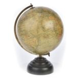
*Globe. Geographia Ltd. (manufacturer), "Geographia" 10 inch Terrestrial Globe, circa 1949, ten inch
*Globe. Geographia Ltd. (manufacturer), "Geographia" 10 inch Terrestrial Globe, circa 1949, ten inch table globe with twelve colour printed gores,...
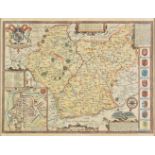
*Hampshire. Speed (John), Hantshire described and devided, published Thomas Bassett & Richard
*Hampshire. Speed (John), Hantshire described and devided, published Thomas Bassett & Richard Chiswell, [1676], hand coloured engraved map, inset ...
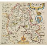
Hertfordshire. Blaeu (Johannis), Hertfordia comitatus vernacule Hertfordshire, Amsterdam, circa
Hertfordshire. Blaeu (Johannis), Hertfordia comitatus vernacule Hertfordshire, Amsterdam, circa 1648, engraved map with contemporary hand colourin...
Hertfordshire. A collection of eleven maps, mostly 18th & 19th century, engraved maps, including
Hertfordshire. A collection of eleven maps, mostly 18th & 19th century, engraved maps, including examples by Norden, Moule, Cary, Seller/Grose, Ba...
Holy Land. Blaeu (Willem Jans Zoon), Terra Sancta quae in sacris Terra Promissionis olim Palestina, Amsterdam 1629 [or later], uncoloured engraved...
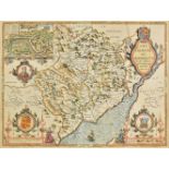
Huntingdonshire. Speed (John), Huntington both shire and shire towne with the ancient citie Ely
Huntingdonshire. Speed (John), Huntington both shire and shire towne with the ancient citie Ely described, published Thomas Bassett & Richard Chis...
*Huntingdonshire. Speed (John), Huntington both shire and shire towne with the ancient citie Ely
*Huntingdonshire. Speed (John), Huntington both shire and shire towne with the ancient citie Ely described, 1st edition, published George Humble, ...
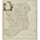
Ireland. Kitchin (Thomas), A new map of Ireland divided into provinces, counties &c., published R.
Ireland. Kitchin (Thomas), A new map of Ireland divided into provinces, counties &c., published R. Sayer & J. Bennett, 1777, engraved map with con...
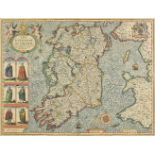
*Ireland. Speed (John), The Kingdome of Irland, devided into severall provinces and then againe into
*Ireland. Speed (John), The Kingdome of Irland, devided into severall provinces and then againe into counties newly described, 1st edition, publis...
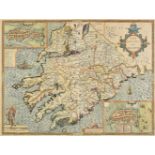
*Ireland. Speed (John), The Province of Mounster, 1st edition, published John Sudbury & George
*Ireland. Speed (John), The Province of Mounster, 1st edition, published John Sudbury & George Humble, [1611], hand coloured engraved map, inset t...
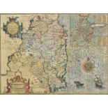
*Ireland. Speed (John), The Countie of Leinster with the citie Dublin described, published John
*Ireland. Speed (John), The Countie of Leinster with the citie Dublin described, published John Sudbury & George Humble, [1611 or later], hand col...
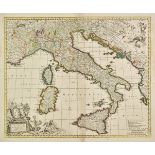
Italy. Visscher (Nicolas), Totius Italiae tabula..., circa 1715, engraved map with contemporary
Italy. Visscher (Nicolas), Totius Italiae tabula..., circa 1715, engraved map with contemporary outline colouring, separate ornamental title and d...
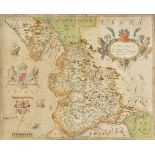
*Lancashire. Saxton (Christopher), Lancastriae comitatus palatin vera et absoluta descriptio,
*Lancashire. Saxton (Christopher), Lancastriae comitatus palatin vera et absoluta descriptio, circa 1579, engraved map with contemporary hand colo...
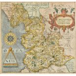
*Lancashire. Saxton (Christopher & Hole G.), Lancastriae comitatus palatinus olim pars Brigantum,
*Lancashire. Saxton (Christopher & Hole G.), Lancastriae comitatus palatinus olim pars Brigantum, 1st edition, [1607], hand coloured engraved map,...
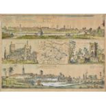
Leeds. Lodge (W. & Thorsby Ralph), The prospects of the two most remarkable towns in the North of
Leeds. Lodge (W. & Thorsby Ralph), The prospects of the two most remarkable towns in the North of England for the clothing trade, viz Leeds as it ...
*Leicestershire. Speed (John), Leicester both countye and Citie described, The Honorable famylies
*Leicestershire. Speed (John), Leicester both countye and Citie described, The Honorable famylies that have had the titles of Earls thereof. With ...
London. Bowles & Carver. Bowles's One-Sheet Plan of the Cities of London and Westminster with the
London. Bowles & Carver. Bowles's One-Sheet Plan of the Cities of London and Westminster with the Borough of Southwark; comprehending their Outski...
*Map jigsaws. Janvier (Jean), L'Afrique divis‚e en ses principaux etats..., Paris, 1780, engraved
*Map jigsaws. Janvier (Jean), L'Afrique divis‚e en ses principaux etats..., Paris, 1780, engraved map with contemporary outline colouring, inset m...
Map reference. A mixed collection of approximately seventy books, mostly 20th century, a collection of map reference books including examples by T...
Map reference. Tooley (R. V.), Collector's guide to the maps of the African continent and Southern
Map reference. Tooley (R. V.), Collector's guide to the maps of the African continent and Southern Africa, Carta Press, 1969, colour printed front...
Maps. A mixed collection of approximately 160 maps, 18th & 19th century, engraved and lithographic
Maps. A mixed collection of approximately 160 maps, 18th & 19th century, engraved and lithographic maps of British counties and foreign countries ...
Maps. A mixed collection of approximately seventy-five maps and charts, mostly 18th & 19th century, engraved maps and sea charts, including exampl...
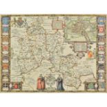
Mercator (Gerard, and Hondius, Jodocus). Warwicum, Northamtonia, Huntingdonia, Cantabrigia, Suffolcia, Oxonium, Buckinghamia, Bedfordia, Hardfordi...
*Mercator (Gerard, and Hondius, Jodocus). Cornubia, Devonia, Somersetus, Dorcestria, Wiltonia,
*Mercator (Gerard, and Hondius, Jodocus). Cornubia, Devonia, Somersetus, Dorcestria, Wiltonia, Glocestria..., Warwicum, Northamtonia, Huntingdonia...
*Middlesex & Hertfordshire. Schenk (Pieter & Valk Gerard), Middelsexiae cum Hertfordiae comitatu
*Middlesex & Hertfordshire. Schenk (Pieter & Valk Gerard), Middelsexiae cum Hertfordiae comitatu Midlesex & Hertfordshire, Amsterdam, circa 1700, ...
*Middlesex. Speed (John & Norden John), Midle-sex described with the most famous cities of London
*Middlesex. Speed (John & Norden John), Midle-sex described with the most famous cities of London and Westminster, 1st edition, published George H...
Midland counties. Blaeu (Johannes), Comitatus Northantonensis vernacule Northamtonshire, Leicestrensis comitatus Leicestershire [and] Rutlandia co...
*Monmouthshire. Speed (John), The countye of Monmouth with the sittuation of the shire-towne
*Monmouthshire. Speed (John), The countye of Monmouth with the sittuation of the shire-towne described, 1st edition, published John Sudbury & Geor...
*Montgomeryshire & Merioneth. Saxton (Christopher), Montgomeri ac Merionidh duorum borialis Cambriae
*Montgomeryshire & Merioneth. Saxton (Christopher), Montgomeri ac Merionidh duorum borialis Cambriae comitatuum B. Gwinedhia A. North Wales nuneup...
![Morocco. Ortelius (Abraham), Fessae et Marocchi regna Africae celeberr describebat, [1606], hand](https://portal-images.azureedge.net/auctions-2019/srdom10124/images/a0ba1270-094f-449c-beec-a9fc00e170a6.jpg?w=155&h=155)
Morocco. Ortelius (Abraham), Fessae et Marocchi regna Africae celeberr describebat, [1606], hand
Morocco. Ortelius (Abraham), Fessae et Marocchi regna Africae celeberr describebat, [1606], hand coloured engraved map, inset map of the Congo, la...
*Morocco. Homann (Johann Baptist), Statuum Maroccanorum, regnorum nempe Fessani, Maroccani, Tafiletani et Segelomessani, Nuremberg, 1728, engraved...
North East England. Saxton (Christopher & Hole G.), Eboracensis comitatus..., vulgo East Riding,
North East England. Saxton (Christopher & Hole G.), Eboracensis comitatus..., vulgo East Riding, Eboracensis comitatus pars Septentrionalis vulgo ...
![North Yorkshire. Hulsberg (T. & Gale Roger), Richmondiae comitatus et Alvertunae Schira, [1722],](https://portal-images.azureedge.net/auctions-2019/srdom10124/images/6d072f0d-126d-4e91-ae8a-a9fc00e171b2.jpg?w=155&h=155)
North Yorkshire. Hulsberg (T. & Gale Roger), Richmondiae comitatus et Alvertunae Schira, [1722],
North Yorkshire. Hulsberg (T. & Gale Roger), Richmondiae comitatus et Alvertunae Schira, [1722], uncoloured engraved map originally published in G...
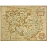
Northamptonshire & Bedfordshire. Saxton (Christopher & Kip William), Northamptoniae comitatus
Northamptonshire & Bedfordshire. Saxton (Christopher & Kip William), Northamptoniae comitatus descriptio in quo coritani olim insederunt [and] Bed...
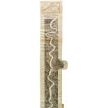
Ogilby (John). The Road from Ipswich com. Suffolk to Norwich and thence Cromer on the Sea Coast com.
Ogilby (John). The Road from Ipswich com. Suffolk to Norwich and thence Cromer on the Sea Coast com. Norfolk, circa 1678, uncoloured strip road ma...
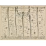
![Ogilby (John). The road from Bristol com. Glos to West Chester, [1675], hand coloured engraved strip](https://portal-images.azureedge.net/auctions-2019/srdom10124/images/2a8bbe06-9d6d-454b-afb2-a9fc00e172ab.jpg?w=155&h=155)
Ogilby (John). The road from Bristol com. Glos to West Chester, [1675], hand coloured engraved strip
Ogilby (John). The road from Bristol com. Glos to West Chester, [1675], hand coloured engraved strip road map, 355 x 445 mm The road runs from Bri...
![Ogilby (John). The road from London to Holy-head co Anglesey North Wales..., [1678], uncoloured](https://portal-images.azureedge.net/auctions-2019/srdom10124/images/0167805e-b732-4461-9749-a9fc00e17332.jpg?w=155&h=155)
Ogilby (John). The road from London to Holy-head co Anglesey North Wales..., [1678], uncoloured
Ogilby (John). The road from London to Holy-head co Anglesey North Wales..., [1678], uncoloured engraved strip road map, large margins, 315 x 440 ...
Oxfordshire & Berkshire. Saxton (Christopher & Hole G.), Oxoniensis comitatus vulgo Oxfordshyre
Oxfordshire & Berkshire. Saxton (Christopher & Hole G.), Oxoniensis comitatus vulgo Oxfordshyre qui pars olim dubunorum, [1637], and Comitatus Ber...
*Oxfordshire. Speed (John), Oxforshire described with ye Citie and the Armes of the Colledges of
*Oxfordshire. Speed (John), Oxforshire described with ye Citie and the Armes of the Colledges of ye famous university, 1st edition, published John...
Rhine. Delkeskamp (Friedrich, Wilhelm), Delkeskamp's Panorama of the Rhine from Cologne to Mayence, published Samuel Leigh, circa 1830, uncoloured...
*Rutland. Speed (John), Rutlandshire with Oukham and Stanford her bordering neighbour newely
*Rutland. Speed (John), Rutlandshire with Oukham and Stanford her bordering neighbour newely described, 1st edition, published John Sudbury & Geor...
*Rutland. Speed (John), Rutlandshire with Oukham and Stanford her bordering neighbour newely
*Rutland. Speed (John), Rutlandshire with Oukham and Stanford her bordering neighbour newely described, published Thomas Bassett & Richard Chiswel...
*Saxton (Christopher, Hole, William & Kip). Warwici comitatus a cornauiis olim inhabitatus. [
*Saxton (Christopher, Hole, William & Kip). Warwici comitatus a cornauiis olim inhabitatus. [1637], Penbrok comitatus olim pars demetarum, circa 1...
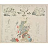
Scotland. A mixed collection of approximately thirty maps, 19th century, engraved map, many with
Scotland. A mixed collection of approximately thirty maps, 19th century, engraved map, many with contemporary outline colouring, including example...
![Scotland. Hole (G.), Scotia regnum, [1610 or later], hand coloured engraved map, strapwork cartouche](https://portal-images.azureedge.net/auctions-2019/srdom10124/images/e3f2d84c-2bec-4ce0-a7e8-a9fc00e175ab.jpg?w=155&h=155)
Scotland. Hole (G.), Scotia regnum, [1610 or later], hand coloured engraved map, strapwork cartouche
Scotland. Hole (G.), Scotia regnum, [1610 or later], hand coloured engraved map, strapwork cartouche and large compass rose, 265 x 315 mm, togethe...
Scotland. Blaeu (Johannes & Pont Timothy), Sterlinensis praefectura. Sterlin-shyr, Cuninghamia ex
Scotland. Blaeu (Johannes & Pont Timothy), Sterlinensis praefectura. Sterlin-shyr, Cuninghamia ex shedis, Lidalia vel Lidisdalia regio Lidisdall [...
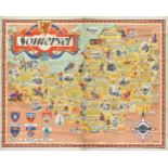
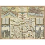
Somerset. Somerset, published British Railways (Western Region), printed by Waterlow and Sons Ltd,
Somerset. Somerset, published British Railways (Western Region), printed by Waterlow and Sons Ltd, circa 1950, large decorative and pictorial colo...
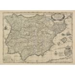
Spain & Portugal. Hondius (Henricus), Typus Hispaniae ab hesselo Gerardo delineata..., 1631,
Spain & Portugal. Hondius (Henricus), Typus Hispaniae ab hesselo Gerardo delineata..., 1631, uncoloured engraved map, very small repaired tear alo...
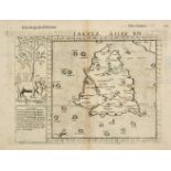
Sri Lanka. Ruscelli (Girolamo), Tabula Asiae XII, circa 1560, uncoloured woodblock map of a Ptolemaic Ceylon, decorated with an Indian elephant, s...