Filtered by:
- Category,
- Item Type
- List
- Grid
A subscription to the Price Guide is required to view results for auctions ten days or older. Click here for more information
![Dury (Andrew). [Atlas Universal et Portatif Contenant 45 Cartes,], circa 1770, with decorative](https://portal-images.azureedge.net/auctions-2019/srdom10122/images/57c680de-fd0d-47d9-8f0a-a9f1011c0c0c.jpg?w=155&h=155)

Dury (Andrew). [Atlas Universal et Portatif Contenant 45 Cartes,], circa 1770, with decorative
Dury (Andrew). [Atlas Universal et Portatif Contenant 45 Cartes,], circa 1770, with decorative calligraphic dedication and list of maps but lackin...
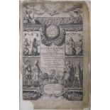
Heylyn (Peter). Cosmographie in Four Books, Containing the Chorographie and Historie of the Whole
Heylyn (Peter). Cosmographie in Four Books, Containing the Chorographie and Historie of the Whole World, and all the Principal Kingdoms, Provinces...
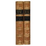
Hinton (John Howard, editor). The History and Topography of the United States, 1st edition, 2 volumes, 1830-32, 17 engraved maps (one partially ha...
Levasseur (Victor). Atlas national illustr‚ des 86 d‚partements et des possessions de la France,
Levasseur (Victor). Atlas national illustr‚ des 86 d‚partements et des possessions de la France, Paris: A. Combette, 1852, engraved title, 47 engr...
![[Montecuccoli, Raimondo]. [Memoires de Montecuculi generalissime des troupes de l'empereur....,](https://portal-images.azureedge.net/auctions-2019/srdom10122/images/27ef8266-d865-4762-8e80-a9ee011e80ad.jpg?w=155&h=155)
[Montecuccoli, Raimondo]. [Memoires de Montecuculi generalissime des troupes de l'empereur....,
[Montecuccoli, Raimondo]. [Memoires de Montecuculi generalissime des troupes de l'empereur...., atlas volume only, new edition, Amsterdam & Leipzi...
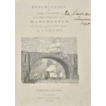
Aikin (J.). A Description of the Country from Thirty to Forty Miles round Manchester, John Stockdale, 1795, engraved allegorical frontispiece, add...
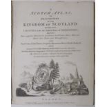
Armstrong (Mostyn John). A Scotch Atlas; or Description of the Kingdom of Scotland: Divided into
Armstrong (Mostyn John). A Scotch Atlas; or Description of the Kingdom of Scotland: Divided into Counties, with the Subdivisions of Sherifdoms; Sh...
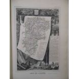
Hoare (Sir Richard Colt). The History of Modern Wiltshire, Hundred of Chalk, by Charles Bowles,
Hoare (Sir Richard Colt). The History of Modern Wiltshire, Hundred of Chalk, by Charles Bowles, 1833, Hundred of South Damerham, by William Henry ...
British Isles. A collection of twenty-four maps, mostly 19th century, engraved and lithographic
British Isles. A collection of twenty-four maps, mostly 19th century, engraved and lithographic maps, including five folding, with examples by Car...
Maps. A large collection of approximately 500 maps, mostly 19th century, British and overseas maps
Maps. A large collection of approximately 500 maps, mostly 19th century, British and overseas maps and charts, together with approximately twenty-...
*Prints & engravings. A mixed collection of approximately 250 prints, maps, engravings and part
*Prints & engravings. A mixed collection of approximately 250 prints, maps, engravings and part volumes, mostly 19th and 20th century, with topogr...
Yorkshire. A mixed collection of approximately sixty-five maps and plans, mostly 19th century,
Yorkshire. A mixed collection of approximately sixty-five maps and plans, mostly 19th century, including twenty engraved and lithographic maps wit...