Refine your search
Sale Section
- Antiquarian (80)
- Art (8)
- British Topography (23)
- Cookery (18)
- Decorative Prints and Original Art (28)
- General Literature (29)
- Historical Documents and Autographs (31)
- Maps and Charts (88)
- Natural History (31)
- Opera Memorabilia: The Collection of Brian Morris (41)
- Periodicals (4)
- Quantity (92)
- Science (10)
- Science and Computing from a Private Collection (52)
- Travel and Exploration (43)
Estimate
Category
- Books & Periodicals (376)
- Maps (103)
- Prints (56)
- Collectables (6)
- Sculpture (5)
- Ceramics (4)
- Musical Instruments & Memorabilia (4)
- Photographs (4)
- Classic Cars, Motorcycles & Automobilia (3)
- Sporting Memorabilia & Equipment (3)
- Arms, Armour & Militaria (2)
- Entertainment Memorabilia (2)
- Stamps (2)
- Textiles (2)
- Watercolours (2)
- Drawings & Pastels (1)
- Furniture (1)
- Salvage & Architectural Antiques (1)
- Scientific Instruments (1)
Filtered by:
- Item Type
- List
- Grid
A subscription to the Price Guide is required to view results for auctions ten days or older. Click here for more information
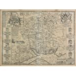

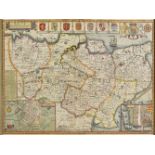
*Hampshire. Speed (John), Hantshire described and devided, J. Sudbury & G. Humble, circa 1627,
*Hampshire. Speed (John), Hantshire described and devided, J. Sudbury & G. Humble, circa 1627, uncoloured engraved map, inset town plan of Winches...
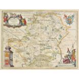
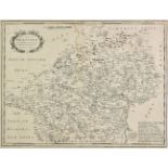
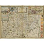
Hertfordshire. Speed (John), Hartford Shire described, the sittuations of Hartford and the most
Hertfordshire. Speed (John), Hartford Shire described, the sittuations of Hartford and the most ancient towne St. Albons with such memorable actio...
![Hertfordshire. Seller (John), Hertforshire actually survey'd and delineated [1679 or later] engraved](https://portal-images.azureedge.net/auctions-2019/srdom10121/images/97fec93a-b3a5-4323-babc-a9d9011b6aa5.jpg?w=155&h=155)
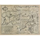
Hertfordshire. Seller (John), Hertforshire actually survey'd and delineated [1679 or later] engraved
Hertfordshire. Seller (John), Hertforshire actually survey'd and delineated [1679 or later] engraved map with contemporary hand colouring, large s...
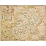
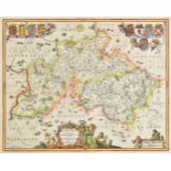
Hertfordshire. Blaeu (Johannes), Hertfordia comitatus Hertfordshire, Amsterdam, circa 1648, engraved
Hertfordshire. Blaeu (Johannes), Hertfordia comitatus Hertfordshire, Amsterdam, circa 1648, engraved map with contemporary hand colouring, large d...
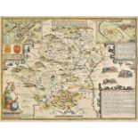
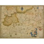
Hertfordshire. Saxton (Christopher), Hartforddiae comitatus nova vera ac particularis descriptio,
Hertfordshire. Saxton (Christopher), Hartforddiae comitatus nova vera ac particularis descriptio, circa 1579, engraved map by Nicolas Reynolds, wi...
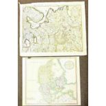
Hertfordshire. A collection of 15 county maps, 17th-19th century, engraved and lithographic maps,
Hertfordshire. A collection of 15 county maps, 17th-19th century, engraved and lithographic maps, many with contemporary colouring, including exam...
Isle of Man. Williams (Commander Geo.), Isle of Man, 1847, lithographic map, trimmed to image, old
Isle of Man. Williams (Commander Geo.), Isle of Man, 1847, lithographic map, trimmed to image, old folds, 315 x 180 mm, with another 7 lithograph...
*Isle of Wight. Speed (John), Wight Island, John Sudbury & George Humble, circa 1627, uncoloured
*Isle of Wight. Speed (John), Wight Island, John Sudbury & George Humble, circa 1627, uncoloured engraved map, inset town plans of Newport and Sou...
Jansson (Johannes). Buckingamiae comitatus cum Bedfordiensi vulgo Buckinghamshire and Bedfordshire, [and] Middelsexiae cum Hertfordiae comitatu Mi...
*Saxton (Christopher). Cantii, Southsexiae, Surriae et Middelsexiae comitat una cum suis undique
*Saxton (Christopher). Cantii, Southsexiae, Surriae et Middelsexiae comitat una cum suis undique consinibus oppidis, pagis, villis et fluminibus i...
*Kent. Speed (John), Kent with her cities and Earles described and observed, Thomas Bassett &
*Kent. Speed (John), Kent with her cities and Earles described and observed, Thomas Bassett & Richard Chiswell, [1676], hand coloured engraved ma...
Lancashire. Cary (John), A Topographical Plan of Manchester and Salford with the adjacent parts
Lancashire. Cary (John), A Topographical Plan of Manchester and Salford with the adjacent parts shewing also the different alloments of land propo...
Maps. A mixed collection of 23 maps, mostly 18th & 19th century, including Bowen (Emanuel), An
Maps. A mixed collection of 23 maps, mostly 18th & 19th century, including Bowen (Emanuel), An accurate map of Northampton Shire divided into its ...
Maps. A mixed collection of thirty-six maps, railway maps and charts, mostly 18th and 19th century, including British county maps, overseas maps, ...
*Maps. Ogilby (John), The continuation of ye extended road from Barnstable to Truro..., [1675 or
*Maps. Ogilby (John), The continuation of ye extended road from Barnstable to Truro..., [1675 or later], hand coloured engraved strip road map, 35...
Maps. A mixed collection of approximately 100 maps, town plans and genealogical tables, 16th -
Maps. A mixed collection of approximately 100 maps, town plans and genealogical tables, 16th - 19th century, engraved and lithographic maps of Can...
Maps. A mixed collection of approximately 150 maps, mostly 18th & 19th century, engraved maps of
Maps. A mixed collection of approximately 150 maps, mostly 18th & 19th century, engraved maps of Germany, France, Italy, Switzerland, Poland, Spai...
Maps. A mixed collection of approximately 100 maps, mostly 18th & 19th century, engraved maps of
Maps. A mixed collection of approximately 100 maps, mostly 18th & 19th century, engraved maps of France, Portugal, Holland, Denmark, East Indies,...
![Mississippi. Law (John), Louisiana by de Rivier Missisippi, Amsterdam, [1720], uncoloured engraved](https://portal-images.azureedge.net/auctions-2019/srdom10121/images/9d08f7e2-dda6-42d6-8cd9-a9d9011b6f09.jpg?w=155&h=155)
Mississippi. Law (John), Louisiana by de Rivier Missisippi, Amsterdam, [1720], uncoloured engraved
Mississippi. Law (John), Louisiana by de Rivier Missisippi, Amsterdam, [1720], uncoloured engraved map of the Mississippi river, Florida and Louis...
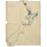
New Zealand. Arrowsmith (John), Map of the colony of New Zealand from official documents, 1844,
New Zealand. Arrowsmith (John), Map of the colony of New Zealand from official documents, 1844, engraved map with contemporary outline colouring o...
*Norfolk. Speed (John), Norfolk, a countie florishing & populous described and devided, with the
*Norfolk. Speed (John), Norfolk, a countie florishing & populous described and devided, with the armes of such noble familes as have borne the tit...
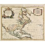
North America. Mortier (Pierre), L'Amerique Septentrionale dressee sur les Observations de Mrs. De
North America. Mortier (Pierre), L'Amerique Septentrionale dressee sur les Observations de Mrs. De L'Academie Royale des Sciences & quelques autre...
North America. Sayer (Robert, & J. Bennett, publishers), North America from the French of Mr. D'
North America. Sayer (Robert, & J. Bennett, publishers), North America from the French of Mr. D'Anville improved with the English Surveys made sin...
North America. A mixed collection of approximately 110 maps, mostly 19th century, country, regional and state maps, including examples by S. D. U....
Ogilby (John). The Road from Oxford to Coventry continued to Darby, The Road from London to Montgomery North Wales, The Road from London to Shrews...

*Oxfordshire. Speed (John), Oxfordshire described with ye citie and armes of the colledges of ye
*Oxfordshire. Speed (John), Oxfordshire described with ye citie and armes of the colledges of ye famous university, published John Sudbury & Georg...

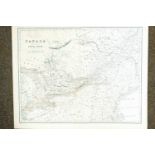
Poland. Senex (John), Poland and other the countries belonging to that crowne according to the
Poland. Senex (John), Poland and other the countries belonging to that crowne according to the newest observations, 1719, engraved map with contem...

Schenk (Petrus). Novissima prae caeteris aliis accuartissima Regnorum Angliae Scotiae Hiberniae..., Amsterdam, circa 1690, engraved map with cont...

Sea charts. A new chart of the southern part of the North Sea shewing the Navigation from the
Sea charts. A new chart of the southern part of the North Sea shewing the Navigation from the Thames, Harwich & the Downes to Calais, Dunkirk, Ost...

Sea charts. A general chart of the Indian and part of the Pacific oceans shewing the various
Sea charts. A general chart of the Indian and part of the Pacific oceans shewing the various passages to & from China, Australia, New Zealand &c.....
Sea charts. Chart of the east Coast of America extending from Cape Canso in Nova Scotia to New York,
Sea charts. Chart of the east Coast of America extending from Cape Canso in Nova Scotia to New York, including plans on a large scale of the Princ...

Sea charts. Bay of Bengal, James Imray & Son, 1872, uncoloured engraved 'blue backed' sea chart,
Sea charts. Bay of Bengal, James Imray & Son, 1872, uncoloured engraved 'blue backed' sea chart, inset maps of ports and harbours, 1010 x 1280 mm...
Sea charts. A new chart of the Skagerrak or Sleeve including the coasts of Norway and Sweden, from
Sea charts. A new chart of the Skagerrak or Sleeve including the coasts of Norway and Sweden, from the Naze to Christiana & Gothenborg, with part ...
*Shropshire & Staffordshire. Jansson (Jan), Salopiensis comitatus cum Staffordiensi. Shropshire &
*Shropshire & Staffordshire. Jansson (Jan), Salopiensis comitatus cum Staffordiensi. Shropshire & Staffordshire, Amsterdam, circa 1650, engraved m...

*Somerset. Bowen (Emanuel), An improved map of the county of Somerset divided into its hundreds laid
*Somerset. Bowen (Emanuel), An improved map of the county of Somerset divided into its hundreds laid down and collected from the best material...,...
South America. A mixed collection of approximately 60 maps, 18th & 19th century, engraved maps of
South America. A mixed collection of approximately 60 maps, 18th & 19th century, engraved maps of the sub-continent, countries and regions, sea ch...

*Suffolk. Speed (John), Suffolke described and divided into hundreds, the situation of the fayre
*Suffolk. Speed (John), Suffolke described and divided into hundreds, the situation of the fayre towne Ipswich shewed with the armes of the most n...
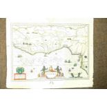
*Sussex. Speed (John), Speed (John), Sussex described and divided into rapes with the situation of
*Sussex. Speed (John), Speed (John), Sussex described and divided into rapes with the situation of Chichester the cheife citie thereof and the arm...

Tasmania. Arrowsmith (John), Map of the South Western or Unexplored Portion of V. D. Land, circa
Tasmania. Arrowsmith (John), Map of the South Western or Unexplored Portion of V. D. Land, circa 1850, lithograph with contemporary outline colour...

Underground map. Beck (H. C.), London Underground Transport, 1937, colour photolithographic map on
Underground map. Beck (H. C.), London Underground Transport, 1937, colour photolithographic map on card, an example of Beck's iconic map of the Lo...
![Underground map. Beck (H. C.), Underground Railways of London, [1933], colour photolithographic map,](https://portal-images.azureedge.net/auctions-2019/srdom10121/images/79e588af-af69-4e27-8492-a9d9011b7691.jpg?w=155&h=155)
Underground map. Beck (H. C.), Underground Railways of London, [1933], colour photolithographic map,
Underground map. Beck (H. C.), Underground Railways of London, [1933], colour photolithographic map, old folds, partially split along folds, 140 x...

Underground map. Beck (H. C.), Railways Diagram of Lines, 1951, Underground Diagram of Lines and
Underground map. Beck (H. C.), Railways Diagram of Lines, 1951, Underground Diagram of Lines and Station Index, 1957, Railways Diagram of Lines an...

Underground map. Garbutt (Paul E. & Hutchinson Harold F.), Diagram of Lines and Station Index, 1963,
Underground map. Garbutt (Paul E. & Hutchinson Harold F.), Diagram of Lines and Station Index, 1963, 1964 & 1965, together three colour printed ma...
![Underground map. Beck (H. C.), Underground Railways of London, [1934], photolithographic map, old](https://portal-images.azureedge.net/auctions-2019/srdom10121/images/4c71a926-96c4-4fec-a3f2-a9d9011b78cc.jpg?w=155&h=155)
Underground map. Beck (H. C.), Underground Railways of London, [1934], photolithographic map, old
Underground map. Beck (H. C.), Underground Railways of London, [1934], photolithographic map, old folds, places of interest and theatres printed o...
![Underground map. Beck (H. C.), Underground Lines, 1945 [and] Underground Diagram of Lines, 1946, 2](https://portal-images.azureedge.net/auctions-2019/srdom10121/images/86e140ef-57df-48ba-9d95-a9d9011b7958.jpg?w=155&h=155)
Underground map. Beck (H. C.), Underground Lines, 1945 [and] Underground Diagram of Lines, 1946, 2
Underground map. Beck (H. C.), Underground Lines, 1945 [and] Underground Diagram of Lines, 1946, 2 photolithographic colour maps of Beck's iconic ...

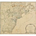
United States. Mount (W. & Page T. publishers), A draught of South Carolina and Georgia from Sewee
United States. Mount (W. & Page T. publishers), A draught of South Carolina and Georgia from Sewee to St. Estaca by Andrew Hughes, circa 1780, unc...

United States. Report of the Superintendent of the Coast Survey showing the Progress of the survey, 1855 - 1862, 34 sea uncoloured sea charts of C...

*Wales. Speed (John), Wales, published John Sudbury & George Humble, circa 1627, hand coloured
*Wales. Speed (John), Wales, published John Sudbury & George Humble, circa 1627, hand coloured engraved map, large compass rose and numerous rhumb...

Warwickshire. Speed (John), The Counti of Warwick The shire towne and citie of Coventre described,
Warwickshire. Speed (John), The Counti of Warwick The shire towne and citie of Coventre described, John Sudbury & George Humble, circa 1627, hand ...
![*Wiltshire. Speed (John), Wilshire, Roger Rea, [1662], uncoloured engraved map, inset town plan of](https://portal-images.azureedge.net/auctions-2019/srdom10121/images/9a3231f3-2450-4b35-9773-a9d9011b7da8.jpg?w=155&h=155)
*Wiltshire. Speed (John), Wilshire, Roger Rea, [1662], uncoloured engraved map, inset town plan of
*Wiltshire. Speed (John), Wilshire, Roger Rea, [1662], uncoloured engraved map, inset town plan of Salisbury and an inset vignette of Stonehenge, ...
World & Polar. A mixed collection of 40 maps of the world, the poles and the hemispheres, mostly
World & Polar. A mixed collection of 40 maps of the world, the poles and the hemispheres, mostly 19th century, engraved maps, several with hand co...

World. Magini (Giovanni Antonio & Rumold Gerard), Orbis Terrae Compendiosa Descriptio ex...,
World. Magini (Giovanni Antonio & Rumold Gerard), Orbis Terrae Compendiosa Descriptio ex..., Rumoldus Mercator..., forma a Hieron: Porro redact, C...
![World. Hondius (Jodocus & Mercator Gerard), Designatio Orbis Christiani, [1609], uncoloured engraved](https://portal-images.azureedge.net/auctions-2019/srdom10121/images/e36e9108-07ef-4903-9ab3-a9d9011b7ef7.jpg?w=155&h=155)
World. Hondius (Jodocus & Mercator Gerard), Designatio Orbis Christiani, [1609], uncoloured engraved
World. Hondius (Jodocus & Mercator Gerard), Designatio Orbis Christiani, [1609], uncoloured engraved map in planispherical form showing the preval...
![World. Cloppenburgh (Jan & Jansson heirs of), Typus Orbis Terrarum, [1630, but 1673 edition],](https://portal-images.azureedge.net/auctions-2019/srdom10121/images/da4f7ea0-3b50-40a8-8c1f-a9d9011b7fba.jpg?w=155&h=155)
World. Cloppenburgh (Jan & Jansson heirs of), Typus Orbis Terrarum, [1630, but 1673 edition],
World. Cloppenburgh (Jan & Jansson heirs of), Typus Orbis Terrarum, [1630, but 1673 edition], uncoloured engraved map, slight staining, 190 x 260...

World. Magini (Giovanni Antonio), Universi orbis descriptio ad usum navigantium, Venice, [1596 or
World. Magini (Giovanni Antonio), Universi orbis descriptio ad usum navigantium, Venice, [1596 or later], uncoloured engraved map, 135 x 180 mm, L...
![World. Porcacchi (Tommaso), Discorso Intorno all Carta da Navigare, Venice, [1604], uncoloured](https://portal-images.azureedge.net/auctions-2019/srdom10121/images/a9007573-5ddb-4253-a125-a9d9011b8146.jpg?w=155&h=155)
World. Porcacchi (Tommaso), Discorso Intorno all Carta da Navigare, Venice, [1604], uncoloured
World. Porcacchi (Tommaso), Discorso Intorno all Carta da Navigare, Venice, [1604], uncoloured engraved map, 105 x 145 mm, Italian text above, bel...
![World. Gerritsz (Hessel), Untitled hemispherical map of the world, Amsterdam, [1612], uncoloured](https://portal-images.azureedge.net/auctions-2019/srdom10121/images/1ab8558a-d5c9-4325-8c70-a9d9011b8226.jpg?w=155&h=155)
World. Gerritsz (Hessel), Untitled hemispherical map of the world, Amsterdam, [1612], uncoloured
World. Gerritsz (Hessel), Untitled hemispherical map of the world, Amsterdam, [1612], uncoloured engraved map, some spotting, closed tear affectin...

World. De Leth (Andries), Mappe Monde ou Description du Globe Terrestre vu en concave ou en creux en
World. De Leth (Andries), Mappe Monde ou Description du Globe Terrestre vu en concave ou en creux en deux Hemispheres, circa 1740, hand coloured e...
![World. Hondius (Jodocus), Typus Orbis Terrarum, Amsterdam, [1607 - 1621], uncoloured engraved map of](https://portal-images.azureedge.net/auctions-2019/srdom10121/images/595262c1-677c-4191-96ee-a9d9011b83aa.jpg?w=155&h=155)
World. Hondius (Jodocus), Typus Orbis Terrarum, Amsterdam, [1607 - 1621], uncoloured engraved map of
World. Hondius (Jodocus), Typus Orbis Terrarum, Amsterdam, [1607 - 1621], uncoloured engraved map of twin hemispheres with a quotation from Psalms...