Filtered by:
- Sale Section,
- Item Type
- List
- Grid
A subscription to the Price Guide is required to view results for auctions ten days or older. Click here for more information
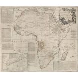

Africa. Laurie (Robert & Whittle James), Africa, with All Its States, Kingdoms, Republics, Regions, Islands, & ca. Improved and inlarged fron D'An...
Americas. Bertius (P. & Tavernier Melchoir), Carte de L'Amerique corrige‚ augmentee; dessus toutes
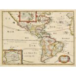
Americas. Bertius (P. & Tavernier Melchoir), Carte de L'Amerique corrige‚ augmentee; dessus toutes les aultres cy devant..., 1639, hand coloured e...
Arrowsmith (John). Untitled atlas, titled on spine 'Arrowsmith's Colonial Atlas' but is a part
Arrowsmith (John). Untitled atlas, titled on spine 'Arrowsmith's Colonial Atlas' but is a part copy of the 'London Atlas of Universal Geography, e...
Australia. Arrowsmith (John), [Map and chart of Norfolk Island from actual survey, 1840, published
Australia. Arrowsmith (John), [Map and chart of Norfolk Island from actual survey, 1840, published 15th June, 1842], lithographic map with contemp...
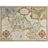
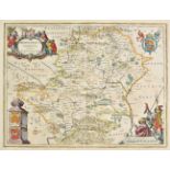
*Bedfordshire. Speed (John), Bedford Shire and the situation of Bedford described with the armes
*Bedfordshire. Speed (John), Bedford Shire and the situation of Bedford described with the armes of thos honorable familyes that have borne ye tit...
Bedfordshire. A collection of 17 county maps, 17th-19th century, engraved and lithographic county
Bedfordshire. A collection of 17 county maps, 17th-19th century, engraved and lithographic county maps, many with hand colouring, including examp...
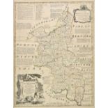
Bowen (Emanuel & Kitchin, Thomas). An Accurate map of Buckinghamshire divided into its hundreds..., J. Tinney, R. Sayer, T & J Bowles, 1756 [and] ...
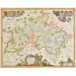
![Bowen (Emanuel). An accurate map of Hartford Shire divided into hundreds [and] An accurate map of](https://portal-images.azureedge.net/auctions-2019/srdom10121/images/1a9d0d00-fa83-408f-93e8-a9d9011b6205.jpg?w=155&h=155)
Bowen (Emanuel). An accurate map of Hartford Shire divided into hundreds [and] An accurate map of
Bowen (Emanuel). An accurate map of Hartford Shire divided into hundreds [and] An accurate map of Buckinghamshire divided into hundreds [and] An a...
British county maps. A mixed collection of approximately 75 maps, mostly 18th & 19th century,
British county maps. A mixed collection of approximately 75 maps, mostly 18th & 19th century, engraved and lithographic maps of British counties, ...
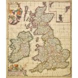
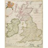
British Isles. De Wit (Frederick), Novissima prae caeteris aliis accuratissima Regnorum Angliae
British Isles. De Wit (Frederick), Novissima prae caeteris aliis accuratissima Regnorum Angliae Scotiae Hiberniae [and] Accuratissima Angliae Regn...
British Isles. Nolin (Jean-Baptiste), Les Isles Britanniques ou sont Les Royaumes d'Angleterre, d'
British Isles. Nolin (Jean-Baptiste), Les Isles Britanniques ou sont Les Royaumes d'Angleterre, d'Ecosse et d'Irlande &c..., Paris, [1698], engrav...
British Isles. A collection of five maps, all 16th century, including Ruscelli (Girolamo), Anglia et
British Isles. A collection of five maps, all 16th century, including Ruscelli (Girolamo), Anglia et Hibernia Nova [and] Tabula Europae I [1561], ...
Buckinghamshire. A collection of 13 county maps, 17th-19th century, engraved and lithographic county
Buckinghamshire. A collection of 13 county maps, 17th-19th century, engraved and lithographic county maps, many with hand colouring, including exa...
*Cornwall. Speed (John), Cornwall, John Sudbury & George Humble, circa 1627, hand coloured engraved map, inset view of Launcston, 380 x 500 mm, E...
*Denbighshire. Speed (John), Denbighshire, John Sudbury & George Humble, 1616, hand coloured
*Denbighshire. Speed (John), Denbighshire, John Sudbury & George Humble, 1616, hand coloured engraved map, inset town plan of Denbigh, framed and ...
*Dorset. Speed (John), Dorsetshyre with the shyre-towne Dorchester described as also the armes of
*Dorset. Speed (John), Dorsetshyre with the shyre-towne Dorchester described as also the armes of such noble families as have bene honored with th...
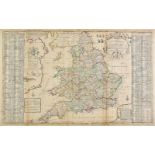
England & Wales. Moll (Herman), The South part of Great Britain called England and Wales..., sold by
England & Wales. Moll (Herman), The South part of Great Britain called England and Wales..., sold by J. & T. Bowles, Philip Overton and John King,...
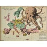
*Europe. Rose (F. W.), Serio-Comic War Map for the Year 1877, published G. W. Bacon & Co., colour
*Europe. Rose (F. W.), Serio-Comic War Map for the Year 1877, published G. W. Bacon & Co., colour lithographic allegorical map, explanation to low...
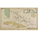
Florida, Cuba and the Bahamas. Van Keulen (Gerard), Nieuwe en Naeukeurige Afteekening vant Canaal
Florida, Cuba and the Bahamas. Van Keulen (Gerard), Nieuwe en Naeukeurige Afteekening vant Canaal van Bahama vertoonde 't geheele Eyland Cuba de N...
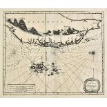
Formosa. Van der Aa (Pierre), L'Ile de Formosa ou sont exactement marquez les bancs de Sables,
Formosa. Van der Aa (Pierre), L'Ile de Formosa ou sont exactement marquez les bancs de Sables, Rochers et Brasses d'Eau..., Leiden, circa 1720, un...
*Gloucestershire. Speed (John), Glocestershire contrived into thirty thre severall hundreds &
*Gloucestershire. Speed (John), Glocestershire contrived into thirty thre severall hundreds & those againe into foure principall devisions. The ci...
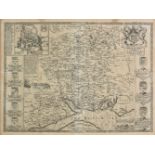
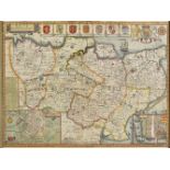
![Greenwood (C. & J.). Map of the county of Buckingham from an actual survey..., 1834 [and] Map of the](https://portal-images.azureedge.net/auctions-2019/srdom10121/images/f022ac13-04b1-4cbd-bfce-a9d9011b6900.jpg?w=155&h=155)
Greenwood (C. & J.). Map of the county of Buckingham from an actual survey..., 1834 [and] Map of the
Greenwood (C. & J.). Map of the county of Buckingham from an actual survey..., 1834 [and] Map of the county of Hertford from an actual survey..., ...
Hampshire, Berkshire & Wiltshire. A mixed collection of 30 maps, 17-19th century, engraved and
Hampshire, Berkshire & Wiltshire. A mixed collection of 30 maps, 17-19th century, engraved and lithographic county maps, town plans and charts, in...
*Hampshire. Speed (John), Hantshire described and devided, J. Sudbury & G. Humble, circa 1627,
*Hampshire. Speed (John), Hantshire described and devided, J. Sudbury & G. Humble, circa 1627, uncoloured engraved map, inset town plan of Winches...
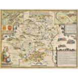
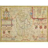
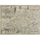
Hertfordshire. Speed (John), Hartford Shire described, the sittuations of Hartford and the most
Hertfordshire. Speed (John), Hartford Shire described, the sittuations of Hartford and the most ancient towne St. Albons with such memorable actio...
![Hertfordshire. Seller (John), Hertforshire actually survey'd and delineated [1679 or later] engraved](https://portal-images.azureedge.net/auctions-2019/srdom10121/images/97fec93a-b3a5-4323-babc-a9d9011b6aa5.jpg?w=155&h=155)
Hertfordshire. Seller (John), Hertforshire actually survey'd and delineated [1679 or later] engraved
Hertfordshire. Seller (John), Hertforshire actually survey'd and delineated [1679 or later] engraved map with contemporary hand colouring, large s...
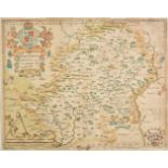
Hertfordshire. Blaeu (Johannes), Hertfordia comitatus Hertfordshire, Amsterdam, circa 1648, engraved
Hertfordshire. Blaeu (Johannes), Hertfordia comitatus Hertfordshire, Amsterdam, circa 1648, engraved map with contemporary hand colouring, large d...
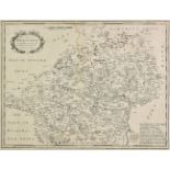
Hertfordshire. Saxton (Christopher), Hartforddiae comitatus nova vera ac particularis descriptio,
Hertfordshire. Saxton (Christopher), Hartforddiae comitatus nova vera ac particularis descriptio, circa 1579, engraved map by Nicolas Reynolds, wi...
Hertfordshire. A collection of 15 county maps, 17th-19th century, engraved and lithographic maps,
Hertfordshire. A collection of 15 county maps, 17th-19th century, engraved and lithographic maps, many with contemporary colouring, including exam...
Isle of Man. Williams (Commander Geo.), Isle of Man, 1847, lithographic map, trimmed to image, old
Isle of Man. Williams (Commander Geo.), Isle of Man, 1847, lithographic map, trimmed to image, old folds, 315 x 180 mm, with another 7 lithograph...
*Isle of Wight. Speed (John), Wight Island, John Sudbury & George Humble, circa 1627, uncoloured
*Isle of Wight. Speed (John), Wight Island, John Sudbury & George Humble, circa 1627, uncoloured engraved map, inset town plans of Newport and Sou...
Jansson (Johannes). Buckingamiae comitatus cum Bedfordiensi vulgo Buckinghamshire and Bedfordshire, [and] Middelsexiae cum Hertfordiae comitatu Mi...
*Saxton (Christopher). Cantii, Southsexiae, Surriae et Middelsexiae comitat una cum suis undique
*Saxton (Christopher). Cantii, Southsexiae, Surriae et Middelsexiae comitat una cum suis undique consinibus oppidis, pagis, villis et fluminibus i...
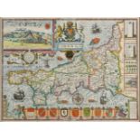
*Kent. Speed (John), Kent with her cities and Earles described and observed, Thomas Bassett &
*Kent. Speed (John), Kent with her cities and Earles described and observed, Thomas Bassett & Richard Chiswell, [1676], hand coloured engraved ma...
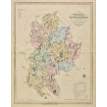
Lancashire. Cary (John), A Topographical Plan of Manchester and Salford with the adjacent parts
Lancashire. Cary (John), A Topographical Plan of Manchester and Salford with the adjacent parts shewing also the different alloments of land propo...
Maps. A mixed collection of 23 maps, mostly 18th & 19th century, including Bowen (Emanuel), An
Maps. A mixed collection of 23 maps, mostly 18th & 19th century, including Bowen (Emanuel), An accurate map of Northampton Shire divided into its ...
Maps. A mixed collection of thirty-six maps, railway maps and charts, mostly 18th and 19th century, including British county maps, overseas maps, ...
*Maps. Ogilby (John), The continuation of ye extended road from Barnstable to Truro..., [1675 or
*Maps. Ogilby (John), The continuation of ye extended road from Barnstable to Truro..., [1675 or later], hand coloured engraved strip road map, 35...
Maps. A mixed collection of approximately 100 maps, town plans and genealogical tables, 16th -
Maps. A mixed collection of approximately 100 maps, town plans and genealogical tables, 16th - 19th century, engraved and lithographic maps of Can...
Maps. A mixed collection of approximately 150 maps, mostly 18th & 19th century, engraved maps of
Maps. A mixed collection of approximately 150 maps, mostly 18th & 19th century, engraved maps of Germany, France, Italy, Switzerland, Poland, Spai...
Maps. A mixed collection of approximately 100 maps, mostly 18th & 19th century, engraved maps of
Maps. A mixed collection of approximately 100 maps, mostly 18th & 19th century, engraved maps of France, Portugal, Holland, Denmark, East Indies,...
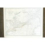
![Mississippi. Law (John), Louisiana by de Rivier Missisippi, Amsterdam, [1720], uncoloured engraved](https://portal-images.azureedge.net/auctions-2019/srdom10121/images/9d08f7e2-dda6-42d6-8cd9-a9d9011b6f09.jpg?w=155&h=155)
Mississippi. Law (John), Louisiana by de Rivier Missisippi, Amsterdam, [1720], uncoloured engraved
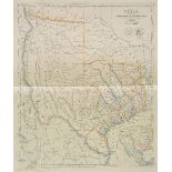
Mississippi. Law (John), Louisiana by de Rivier Missisippi, Amsterdam, [1720], uncoloured engraved map of the Mississippi river, Florida and Louis...
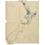
New Zealand. Arrowsmith (John), Map of the colony of New Zealand from official documents, 1844,
New Zealand. Arrowsmith (John), Map of the colony of New Zealand from official documents, 1844, engraved map with contemporary outline colouring o...
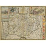
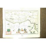
*Norfolk. Speed (John), Norfolk, a countie florishing & populous described and devided, with the
*Norfolk. Speed (John), Norfolk, a countie florishing & populous described and devided, with the armes of such noble familes as have borne the tit...
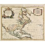
North America. Mortier (Pierre), L'Amerique Septentrionale dressee sur les Observations de Mrs. De
North America. Mortier (Pierre), L'Amerique Septentrionale dressee sur les Observations de Mrs. De L'Academie Royale des Sciences & quelques autre...
North America. Sayer (Robert, & J. Bennett, publishers), North America from the French of Mr. D'
North America. Sayer (Robert, & J. Bennett, publishers), North America from the French of Mr. D'Anville improved with the English Surveys made sin...
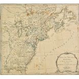
North America. A mixed collection of approximately 110 maps, mostly 19th century, country, regional and state maps, including examples by S. D. U....
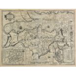
Ogilby (John). The Road from Oxford to Coventry continued to Darby, The Road from London to Montgomery North Wales, The Road from London to Shrews...

*Oxfordshire. Speed (John), Oxfordshire described with ye citie and armes of the colledges of ye
*Oxfordshire. Speed (John), Oxfordshire described with ye citie and armes of the colledges of ye famous university, published John Sudbury & Georg...

Poland. Senex (John), Poland and other the countries belonging to that crowne according to the
Poland. Senex (John), Poland and other the countries belonging to that crowne according to the newest observations, 1719, engraved map with contem...

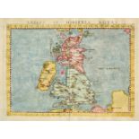
Schenk (Petrus). Novissima prae caeteris aliis accuartissima Regnorum Angliae Scotiae Hiberniae..., Amsterdam, circa 1690, engraved map with cont...

Sea charts. A new chart of the southern part of the North Sea shewing the Navigation from the
Sea charts. A new chart of the southern part of the North Sea shewing the Navigation from the Thames, Harwich & the Downes to Calais, Dunkirk, Ost...

Sea charts. A general chart of the Indian and part of the Pacific oceans shewing the various
Sea charts. A general chart of the Indian and part of the Pacific oceans shewing the various passages to & from China, Australia, New Zealand &c.....
Sea charts. Chart of the east Coast of America extending from Cape Canso in Nova Scotia to New York,
Sea charts. Chart of the east Coast of America extending from Cape Canso in Nova Scotia to New York, including plans on a large scale of the Princ...

Sea charts. Bay of Bengal, James Imray & Son, 1872, uncoloured engraved 'blue backed' sea chart,
Sea charts. Bay of Bengal, James Imray & Son, 1872, uncoloured engraved 'blue backed' sea chart, inset maps of ports and harbours, 1010 x 1280 mm...
Sea charts. A new chart of the Skagerrak or Sleeve including the coasts of Norway and Sweden, from
Sea charts. A new chart of the Skagerrak or Sleeve including the coasts of Norway and Sweden, from the Naze to Christiana & Gothenborg, with part ...
*Shropshire & Staffordshire. Jansson (Jan), Salopiensis comitatus cum Staffordiensi. Shropshire &
*Shropshire & Staffordshire. Jansson (Jan), Salopiensis comitatus cum Staffordiensi. Shropshire & Staffordshire, Amsterdam, circa 1650, engraved m...

*Somerset. Bowen (Emanuel), An improved map of the county of Somerset divided into its hundreds laid
*Somerset. Bowen (Emanuel), An improved map of the county of Somerset divided into its hundreds laid down and collected from the best material...,...
South America. A mixed collection of approximately 60 maps, 18th & 19th century, engraved maps of
South America. A mixed collection of approximately 60 maps, 18th & 19th century, engraved maps of the sub-continent, countries and regions, sea ch...

*Suffolk. Speed (John), Suffolke described and divided into hundreds, the situation of the fayre
*Suffolk. Speed (John), Suffolke described and divided into hundreds, the situation of the fayre towne Ipswich shewed with the armes of the most n...