Refine your search
Filtered by:
- Sale Section,
- Creator / Brand
- List
- Grid
A subscription to the Price Guide is required to view results for auctions ten days or older. Click here for more information
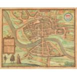

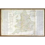
Bristol. Braun (Georg & Hogenberg Frans), Brightstowe vulgo quondam venta flore tissimum Angliae
Bristol. Braun (Georg & Hogenberg Frans), Brightstowe vulgo quondam venta flore tissimum Angliae Emporium, [1581], engraved map with contemporary...
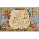
British Islands. A collection of nine maps, 17th - 19th century, including maps of the Channel
British Islands. A collection of nine maps, 17th - 19th century, including maps of the Channel Islands, the Isle of Man and 'collections' of Briti...
British Isles. A collection of ten maps, mostly 18th century, engraved maps including six with
British Isles. A collection of ten maps, mostly 18th century, engraved maps including six with hand colouring, with examples by Moll, Cellarius, B...
![British Isles. Bordone (Benedetto), Inghilterra secondo Tolemeo [printed on map], 1st edition,](https://portal-images.azureedge.net/auctions-2018/srdom10120/images/c3c3ee8b-ccd3-496d-9ccd-a9a801324e53.jpg?w=155&h=155)
British Isles. Bordone (Benedetto), Inghilterra secondo Tolemeo [printed on map], 1st edition,
British Isles. Bordone (Benedetto), Inghilterra secondo Tolemeo [printed on map], 1st edition, published Venice, [1528], uncoloured woodblock map ...
![British Isles. Ruscelli (Girolamo), Tabula Europae I, Venice, [1574], hand coloured engraved '](https://portal-images.azureedge.net/auctions-2018/srdom10120/images/ba1b06ae-844f-44ff-b9b6-a9a801324f53.jpg?w=155&h=155)
British Isles. Ruscelli (Girolamo), Tabula Europae I, Venice, [1574], hand coloured engraved '
British Isles. Ruscelli (Girolamo), Tabula Europae I, Venice, [1574], hand coloured engraved 'Ptolemaic' map on a trapezoidal projection with Scot...
British Isles. Schenk (Petrus), Novissima prae caeteris aliis accuartissima Regnorum Angliae Scotiae
British Isles. Schenk (Petrus), Novissima prae caeteris aliis accuartissima Regnorum Angliae Scotiae Hiberniae..., Amsterdam, circa 1690, engraved...
British Isles. A mixed collection of seventeen maps, mostly 18th century, engraved maps, thirteen
British Isles. A mixed collection of seventeen maps, mostly 18th century, engraved maps, thirteen with hand colouring, with examples by Buffier, S...
British Isles. A collection of twenty maps, 18th & 19th century, engraved maps, fourteen with hand
British Isles. A collection of twenty maps, 18th & 19th century, engraved maps, fourteen with hand colouring, with examples by Tallis, Cary, Reill...
*British Isles. Pine (John), A Chart shewing the several Places of Action between the English and
*British Isles. Pine (John), A Chart shewing the several Places of Action between the English and Spanish Fleets, with the Places where several of...
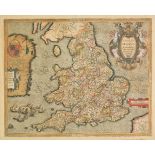
*British Isles. Saxton (Christopher & Hole William), Englalond Anglia Anglo Saxonum Heptarchia [1607
*British Isles. Saxton (Christopher & Hole William), Englalond Anglia Anglo Saxonum Heptarchia [1607 - 1610], hand coloured engraved map, one old ...
*Cheshire. Blaeu (Johannes), Cestria comitatus Palatinus, circa 1645, engraved map with contemporary
*Cheshire. Blaeu (Johannes), Cestria comitatus Palatinus, circa 1645, engraved map with contemporary hand colouring, decorative cartouche and mile...
*Cheshire. Blaeu (Johannes), Cestria comitatus palatinus, circa 1645, engraved map with contemporary
*Cheshire. Blaeu (Johannes), Cestria comitatus palatinus, circa 1645, engraved map with contemporary hand colouring, some printer's creases, 385 x...
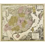
*China. Seutter (George Matthaus), Opulentissimum Sinarum Imperium juxta recentissimam delineationem
*China. Seutter (George Matthaus), Opulentissimum Sinarum Imperium juxta recentissimam delineationem in suas provincias disterminatum cura et sunt...
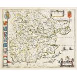
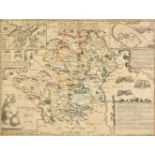
Derbyshire. Speed (John), Anno Darbieshire described, published John Sudbury & George Humble,
Derbyshire. Speed (John), Anno Darbieshire described, published John Sudbury & George Humble, circa 1627, uncoloured engraved map, inset town plan...
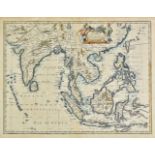
*East Indies. Speed (John), A new map of East India, published Thomas Bassett & Richard Chiswell, [
*East Indies. Speed (John), A new map of East India, published Thomas Bassett & Richard Chiswell, [1676], hand coloured engraved map, large margin...
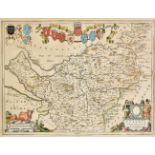
East Yorkshire. Bowen (Emanuel), An accurate map of the East Riding of Yorkshire divided into its
East Yorkshire. Bowen (Emanuel), An accurate map of the East Riding of Yorkshire divided into its Wapontakes &c. Drawn from surveys with various a...
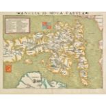
England & Wales. Quad (Matthias), Angliae regni florentissimi nova descriptio auctore Humeredo Lhuyd
England & Wales. Quad (Matthias), Angliae regni florentissimi nova descriptio auctore Humeredo Lhuyd Denbygiense, Cologne, [1592 or later], hand c...
England & Wales. Browne (Christopher), A new map of England. To the most exellent Majesties of
England & Wales. Browne (Christopher), A new map of England. To the most exellent Majesties of William & Mary of England, Scotland, France & Irela...
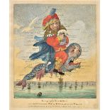
England & Wales. Geography Bewitched! or, a droll caricature map of England & Wales. Printed for
England & Wales. Geography Bewitched! or, a droll caricature map of England & Wales. Printed for Bowles & Carver, 4th June, 1794, engraved allegor...
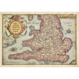
*England & Wales. Saxton (Christopher & Ortelius Abraham), Anglia regnum si quod aliud in toto
*England & Wales. Saxton (Christopher & Ortelius Abraham), Anglia regnum si quod aliud in toto Oceano ditissimum et florentissimum, published Jan ...
*England & Wales. Munster (Sebastian), Anglia II. Nova Tabula, published Basle, circa 1550, woodcut map with early outline colouring, key with pro...
Essex. Chapman (John & Andre Peter), Nineteen sheets only from the large scale 'A map of the
Essex. Chapman (John & Andre Peter), Nineteen sheets only from the large scale 'A map of the county of Essex..., ' numbers 1 - 7, 10 - 12, 14 - 16...
Essex. Blaeu (Johannes), Essexia comitatus, published Amsterdam, circa 1645, engraved map with
Essex. Blaeu (Johannes), Essexia comitatus, published Amsterdam, circa 1645, engraved map with contemporary hand colouring, 420 x 525 mm, Dutch te...
Folding maps. Wyld (James), Wyld's Military Staff Map of Central Asia and Afghanistan, circa 1870,
Folding maps. Wyld (James), Wyld's Military Staff Map of Central Asia and Afghanistan, circa 1870, lithographic map with contemporary outline colo...
Folding maps. A collection of thirteen maps, 19th & early 20th century, including Betts (John),
Folding maps. A collection of thirteen maps, 19th & early 20th century, including Betts (John), Betts's new Map of India, Birmah, The Punjab and p...
France & Belgium. Lotter (Tobias Conrad), Mappa geographica in qua Ducatus Lotharingiae et Barr..., Augsburg, circa 1740, engraved map with contem...
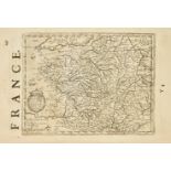
France. Mercator (Gerard & Hondius Henricus), a collection of thirty-four maps, circa 1635, uncoloured engraved maps of France (and three of Switz...
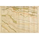
Geological Maps. Ibbeson (J.), Section of Strata of the South Yorkshire Coal field..., published
Geological Maps. Ibbeson (J.), Section of Strata of the South Yorkshire Coal field..., published Pawson & Brailsford, Sheffield, 1869, colour lith...
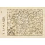
Germany. Mercator (Gerard & Hondius Henricus), A collection of thirty-two maps of Germany & Austria,
Germany. Mercator (Gerard & Hondius Henricus), A collection of thirty-two maps of Germany & Austria, circa 1635, uncoloured engraved maps, partial...
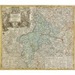
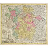
Germany. Lotter (Tobias Conrad), Nova et accuratior repraesentatio geographica Sacr. Rom. Imperii
Germany. Lotter (Tobias Conrad), Nova et accuratior repraesentatio geographica Sacr. Rom. Imperii episcopatus Wurceburgensis Francie Orientalis du...
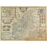
Gloucestershire. Speed (John), Glocestershire contrived into thirty thre severall hundreds & those
Gloucestershire. Speed (John), Glocestershire contrived into thirty thre severall hundreds & those againe into foure principall devisions. The cit...
*Gloucestershire. Speed (John), Glocestershire contrived into thirty thre severall hundreds &
*Gloucestershire. Speed (John), Glocestershire contrived into thirty thre severall hundreds & those againe into foure principall devisions. The ci...
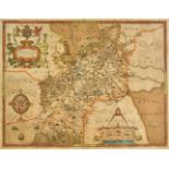
*Gloucestershire. Saxton (Christopher), Glocestriae sive Claudiocestriae Comit (Claudy Caesaris
*Gloucestershire. Saxton (Christopher), Glocestriae sive Claudiocestriae Comit (Claudy Caesaris Nomine ad huc Celebrat) Verus Tipus atq Effigies. ...
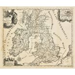
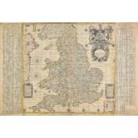
Great Britain. Senex (John & Price Charles), A new map of Great Britain corrected from the observations communicated to the Royal Society at Londo...
*Hertfordshire. Speed (John), Hartford Shire described. The sittuations of Hartford and the most
*Hertfordshire. Speed (John), Hartford Shire described. The sittuations of Hartford and the most ancient towne S. Albans with such memorable actio...
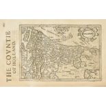
Holland & Belgium. A mixed collection of approximately sixty maps, 17th - 19th century, engraved
Holland & Belgium. A mixed collection of approximately sixty maps, 17th - 19th century, engraved country and regional maps, battle and town plans,...
Hungary. Schenk (Petrus), Nova Et Accurata Tabula Sedis Belli In Regno Hungariae. Accedunt Cetera
Hungary. Schenk (Petrus), Nova Et Accurata Tabula Sedis Belli In Regno Hungariae. Accedunt Cetera Regna, Sclavonia, Croatia, Bosnia et Servia: ut ...
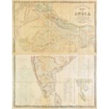
India. Stanford (Edward, publisher), Stanford's map of India based on the surveys executed by
India. Stanford (Edward, publisher), Stanford's map of India based on the surveys executed by order of the Honourable The East India Company..., s...
Ireland. Ordnance Survey (publishers), Index to the Townland Survey of the County of Louth and the
Ireland. Ordnance Survey (publishers), Index to the Townland Survey of the County of Louth and the County of the Town of Drogheda, Index to the To...
Laso (Francisco). A collection of seventeen maps originally published in 'El Atlas Abreviado o
Laso (Francisco). A collection of seventeen maps originally published in 'El Atlas Abreviado o compendiosa...,' published Madrid, [1709], seventee...
Leicestershire & Rutland. A mixed collection of twenty-seven county maps, 17th - 19th century,
Leicestershire & Rutland. A mixed collection of twenty-seven county maps, 17th - 19th century, engraved maps, including examples by Speed, Owen & ...
Leicestershire. Speed (John), Leicester both countye and citie described, The honorable famylies
Leicestershire. Speed (John), Leicester both countye and citie described, The honorable famylies that have had the titles of earls thereof. With o...
Leicestershire. Speed (John), Leicester both countye and citie described, The honorable famylies
Leicestershire. Speed (John), Leicester both countye and citie described, The honorable famylies that have had the titles of earls thereof. With o...
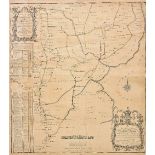
Lincolnshire. Bee (Stephen), A Survey and Plan of the road from the city of Lincoln. Over the Heath,
Lincolnshire. Bee (Stephen), A Survey and Plan of the road from the city of Lincoln. Over the Heath, thro' Dunsby Lane, Sleford, Folkingham, Bourn...
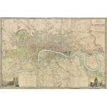
London. Greenwood (C. & J.), Map of London from an actual survey made in the years 1824, 1825 &
London. Greenwood (C. & J.), Map of London from an actual survey made in the years 1824, 1825 & 1826..., extended and comprising the various impro...
London. Cary (John), Cary's New and Accurate plan of London and Westminster, the borough of Southwark and parts adjacent..., 1819, large engraved ...
Maps. A mixed collection of approximately seventy-five maps and charts, 17th - 19th century engraved
Maps. A mixed collection of approximately seventy-five maps and charts, 17th - 19th century engraved maps, charts and town plans, including exampl...
Maps. A mixed collection of approximately 350 maps, charts and town plans, 18th - 20th century,
Maps. A mixed collection of approximately 350 maps, charts and town plans, 18th - 20th century, engraved and lithographic maps including foreign c...
Maps. A mixed collection of approximately 110 maps, 17th - 19th century, engraved regional and
Maps. A mixed collection of approximately 110 maps, 17th - 19th century, engraved regional and country maps, battle and town plans, mostly of cent...
Maps. A mixed collection of approximately 170 British county and road maps, 18th & 19th century,
Maps. A mixed collection of approximately 170 British county and road maps, 18th & 19th century, engraved maps, including examples by Lewis, Hall,...
Mercator (Gerard, and Hondius, Jodocus). A collection of eighteen maps of Germany, Switzerland and
Mercator (Gerard, and Hondius, Jodocus). A collection of eighteen maps of Germany, Switzerland and the Low Countries, circa 1635, eighteen uncolou...
Middle East. Stanford (Edward, publishers), Untitled map of Syria, Palestine, and Turkey, printed by
Middle East. Stanford (Edward, publishers), Untitled map of Syria, Palestine, and Turkey, printed by the Survey of Egypt under authority from the ...
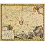
Military maps. De Pontault (Sebastien), Plan de la ville de Bourbour en Flandre assieg‚ par l'arm‚
Military maps. De Pontault (Sebastien), Plan de la ville de Bourbour en Flandre assieg‚ par l'arm‚e du Roy..., [and] Plan du Fort de Link assieg‚ ...
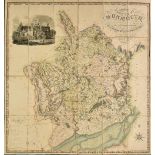
Monmouthshire. Greenwood (C. & H.), Map of the county of Monmouth, from an actual survey made in the
Monmouthshire. Greenwood (C. & H.), Map of the county of Monmouth, from an actual survey made in the years 1829 & 1830..., published August 23rd. ...
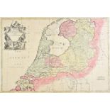
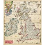
Netherlands. Senex (John), The VII United Provinces corrected from the observations communicated
Netherlands. Senex (John), The VII United Provinces corrected from the observations communicated to the Royal Society at London & ye Royal Academy...
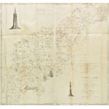
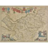
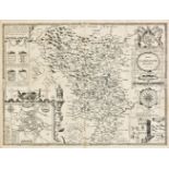
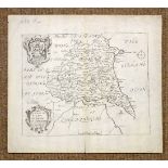
Northamptonshire. Eyre (Thomas & Jefferys Thomas), The county of Northampton as surveyed and
Northamptonshire. Eyre (Thomas & Jefferys Thomas), The county of Northampton as surveyed and planned..., 2nd edition, published William Faden, 179...
![Northamptonshire. Speed (John), Northampton, published Thomas Bassett & Richard Chiswell, [1676],](https://portal-images.azureedge.net/auctions-2018/srdom10120/images/9187f056-90b0-4167-849c-a9a801327862.jpg?w=155&h=155)
Northamptonshire. Speed (John), Northampton, published Thomas Bassett & Richard Chiswell, [1676],
Northamptonshire. Speed (John), Northampton, published Thomas Bassett & Richard Chiswell, [1676], hand coloured engraved map, inset town plans of ...

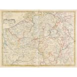
Northern England. A collection of twenty-two regional maps, 17th & 18th century, engraved regional
Northern England. A collection of twenty-two regional maps, 17th & 18th century, engraved regional maps of north east and north west England, incl...
![Northern England. Lamberti (Aniello), Carta II. per L'Inghilterra, published Florence, [1779],](https://portal-images.azureedge.net/auctions-2018/srdom10120/images/a4833203-54c5-4dd5-9d96-a9a801327995.jpg?w=155&h=155)
Northern England. Lamberti (Aniello), Carta II. per L'Inghilterra, published Florence, [1779],
Northern England. Lamberti (Aniello), Carta II. per L'Inghilterra, published Florence, [1779], engraved playing card map of the northern half of E...
Nottinghamshire. A collection of thirteen maps, 17th - 19th century, engraved maps, including
Nottinghamshire. A collection of thirteen maps, 17th - 19th century, engraved maps, including examples by Bowen, Morden, Saxton/Kip, Moll, Owen & ...