Refine your search
Sale Section
Remove filter- Antiquarian (72)
- Antiquarian Juvenile Books (13)
- Art and Architecture Reference (13)
- Book Furniture (2)
- British Topography (28)
- Children's and Illustrated Books (88)
- Decorative and Natural History Prints (41)
- E.P. Goldschmidt Archive (10)
- Early Printed and Manuscript Music (7)
- General Literature (26)
- Historical Documents and Ephemera (11)
- Islamic and Eastern Books and Manuscripts (13)
- Literary and Historical Autographs (33)
- Maps (86)
- Modern First Editions (79)
- Modern Literature (9)
- Natural History (62)
- Original Art by British Illustrators (43)
- Paintings, Watercolours and Modern Prints (80)
- Periodicals (4)
- Private Press Books (57)
- Quantity (101)
- Teddy Bears, Toys and Games (23)
- The Martin Woodcock Ornithological Library (36)
- The Rubaiyat of Omar Khayyam (30)
- Travel and Exploration (37)
Estimate
Category
- Books & Periodicals (660)
- Maps (97)
- Prints (90)
- Watercolours (59)
- Oil, Acrylic paintings & Mixed Media (24)
- Drawings & Pastels (15)
- Models, Toys, Dolls & Games (13)
- Arms, Armour & Militaria (10)
- Collectables (8)
- Sporting Memorabilia & Equipment (8)
- Taxidermy & Natural History (5)
- Bank notes (2)
- Furniture (2)
- Musical Instruments & Memorabilia (2)
- Vintage Fashion (2)
- Ceramics (1)
- Chinese Works of Art (1)
- Coins (1)
- Entertainment Memorabilia (1)
- Islamic Works of Art (1)
- Photographs (1)
- Salvage & Architectural Antiques (1)
Filtered by:
- Sale Section
- List
- Grid
A subscription to the Price Guide is required to view results for auctions ten days or older. Click here for more information
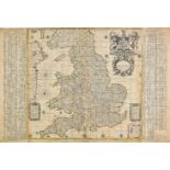

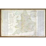
England & Wales. Browne (Christopher), A new map of England. To the most exellent Majesties of
England & Wales. Browne (Christopher), A new map of England. To the most exellent Majesties of William & Mary of England, Scotland, France & Irela...
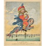
England & Wales. Geography Bewitched! or, a droll caricature map of England & Wales. Printed for
England & Wales. Geography Bewitched! or, a droll caricature map of England & Wales. Printed for Bowles & Carver, 4th June, 1794, engraved allegor...
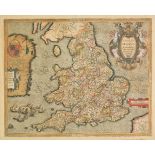
*England & Wales. Saxton (Christopher & Ortelius Abraham), Anglia regnum si quod aliud in toto
*England & Wales. Saxton (Christopher & Ortelius Abraham), Anglia regnum si quod aliud in toto Oceano ditissimum et florentissimum, published Jan ...
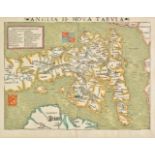
*England & Wales. Munster (Sebastian), Anglia II. Nova Tabula, published Basle, circa 1550, woodcut map with early outline colouring, key with pro...
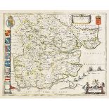
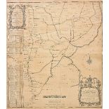
Essex. Chapman (John & Andre Peter), Nineteen sheets only from the large scale 'A map of the
Essex. Chapman (John & Andre Peter), Nineteen sheets only from the large scale 'A map of the county of Essex..., ' numbers 1 - 7, 10 - 12, 14 - 16...
Essex. Blaeu (Johannes), Essexia comitatus, published Amsterdam, circa 1645, engraved map with
Essex. Blaeu (Johannes), Essexia comitatus, published Amsterdam, circa 1645, engraved map with contemporary hand colouring, 420 x 525 mm, Dutch te...
Folding maps. Wyld (James), Wyld's Military Staff Map of Central Asia and Afghanistan, circa 1870,
Folding maps. Wyld (James), Wyld's Military Staff Map of Central Asia and Afghanistan, circa 1870, lithographic map with contemporary outline colo...
Folding maps. A collection of thirteen maps, 19th & early 20th century, including Betts (John),
Folding maps. A collection of thirteen maps, 19th & early 20th century, including Betts (John), Betts's new Map of India, Birmah, The Punjab and p...
France & Belgium. Lotter (Tobias Conrad), Mappa geographica in qua Ducatus Lotharingiae et Barr..., Augsburg, circa 1740, engraved map with contem...
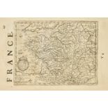
France. Mercator (Gerard & Hondius Henricus), a collection of thirty-four maps, circa 1635, uncoloured engraved maps of France (and three of Switz...
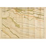
Geological Maps. Ibbeson (J.), Section of Strata of the South Yorkshire Coal field..., published
Geological Maps. Ibbeson (J.), Section of Strata of the South Yorkshire Coal field..., published Pawson & Brailsford, Sheffield, 1869, colour lith...
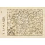
Germany. Mercator (Gerard & Hondius Henricus), A collection of thirty-two maps of Germany & Austria,
Germany. Mercator (Gerard & Hondius Henricus), A collection of thirty-two maps of Germany & Austria, circa 1635, uncoloured engraved maps, partial...
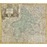
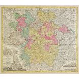
Germany. Lotter (Tobias Conrad), Nova et accuratior repraesentatio geographica Sacr. Rom. Imperii
Germany. Lotter (Tobias Conrad), Nova et accuratior repraesentatio geographica Sacr. Rom. Imperii episcopatus Wurceburgensis Francie Orientalis du...
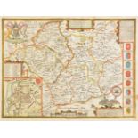
Gloucestershire. Speed (John), Glocestershire contrived into thirty thre severall hundreds & those
Gloucestershire. Speed (John), Glocestershire contrived into thirty thre severall hundreds & those againe into foure principall devisions. The cit...
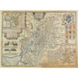
*Gloucestershire. Speed (John), Glocestershire contrived into thirty thre severall hundreds &
*Gloucestershire. Speed (John), Glocestershire contrived into thirty thre severall hundreds & those againe into foure principall devisions. The ci...
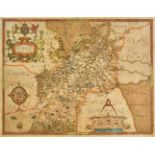
*Gloucestershire. Saxton (Christopher), Glocestriae sive Claudiocestriae Comit (Claudy Caesaris
*Gloucestershire. Saxton (Christopher), Glocestriae sive Claudiocestriae Comit (Claudy Caesaris Nomine ad huc Celebrat) Verus Tipus atq Effigies. ...
Great Britain. Senex (John & Price Charles), A new map of Great Britain corrected from the observations communicated to the Royal Society at Londo...
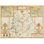
*Hertfordshire. Speed (John), Hartford Shire described. The sittuations of Hartford and the most
*Hertfordshire. Speed (John), Hartford Shire described. The sittuations of Hartford and the most ancient towne S. Albans with such memorable actio...
Holland & Belgium. A mixed collection of approximately sixty maps, 17th - 19th century, engraved
Holland & Belgium. A mixed collection of approximately sixty maps, 17th - 19th century, engraved country and regional maps, battle and town plans,...
Hungary. Schenk (Petrus), Nova Et Accurata Tabula Sedis Belli In Regno Hungariae. Accedunt Cetera
Hungary. Schenk (Petrus), Nova Et Accurata Tabula Sedis Belli In Regno Hungariae. Accedunt Cetera Regna, Sclavonia, Croatia, Bosnia et Servia: ut ...
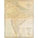
India. Stanford (Edward, publisher), Stanford's map of India based on the surveys executed by
India. Stanford (Edward, publisher), Stanford's map of India based on the surveys executed by order of the Honourable The East India Company..., s...
Ireland. Ordnance Survey (publishers), Index to the Townland Survey of the County of Louth and the
Ireland. Ordnance Survey (publishers), Index to the Townland Survey of the County of Louth and the County of the Town of Drogheda, Index to the To...
Laso (Francisco). A collection of seventeen maps originally published in 'El Atlas Abreviado o
Laso (Francisco). A collection of seventeen maps originally published in 'El Atlas Abreviado o compendiosa...,' published Madrid, [1709], seventee...
Leicestershire & Rutland. A mixed collection of twenty-seven county maps, 17th - 19th century,
Leicestershire & Rutland. A mixed collection of twenty-seven county maps, 17th - 19th century, engraved maps, including examples by Speed, Owen & ...
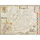
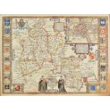
Leicestershire. Speed (John), Leicester both countye and citie described, The honorable famylies
Leicestershire. Speed (John), Leicester both countye and citie described, The honorable famylies that have had the titles of earls thereof. With o...
Leicestershire. Speed (John), Leicester both countye and citie described, The honorable famylies
Leicestershire. Speed (John), Leicester both countye and citie described, The honorable famylies that have had the titles of earls thereof. With o...
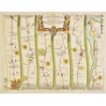
Lincolnshire. Bee (Stephen), A Survey and Plan of the road from the city of Lincoln. Over the Heath,
Lincolnshire. Bee (Stephen), A Survey and Plan of the road from the city of Lincoln. Over the Heath, thro' Dunsby Lane, Sleford, Folkingham, Bourn...
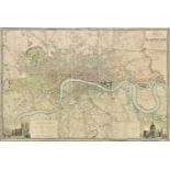
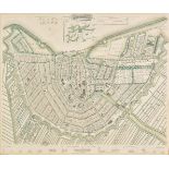
London. Greenwood (C. & J.), Map of London from an actual survey made in the years 1824, 1825 &
London. Greenwood (C. & J.), Map of London from an actual survey made in the years 1824, 1825 & 1826..., extended and comprising the various impro...
London. Cary (John), Cary's New and Accurate plan of London and Westminster, the borough of Southwark and parts adjacent..., 1819, large engraved ...
Maps. A mixed collection of approximately seventy-five maps and charts, 17th - 19th century engraved
Maps. A mixed collection of approximately seventy-five maps and charts, 17th - 19th century engraved maps, charts and town plans, including exampl...
Maps. A mixed collection of approximately 350 maps, charts and town plans, 18th - 20th century,
Maps. A mixed collection of approximately 350 maps, charts and town plans, 18th - 20th century, engraved and lithographic maps including foreign c...
Maps. A mixed collection of approximately 110 maps, 17th - 19th century, engraved regional and
Maps. A mixed collection of approximately 110 maps, 17th - 19th century, engraved regional and country maps, battle and town plans, mostly of cent...
Maps. A mixed collection of approximately 170 British county and road maps, 18th & 19th century,
Maps. A mixed collection of approximately 170 British county and road maps, 18th & 19th century, engraved maps, including examples by Lewis, Hall,...
Mercator (Gerard, and Hondius, Jodocus). A collection of eighteen maps of Germany, Switzerland and
Mercator (Gerard, and Hondius, Jodocus). A collection of eighteen maps of Germany, Switzerland and the Low Countries, circa 1635, eighteen uncolou...
Middle East. Stanford (Edward, publishers), Untitled map of Syria, Palestine, and Turkey, printed by
Middle East. Stanford (Edward, publishers), Untitled map of Syria, Palestine, and Turkey, printed by the Survey of Egypt under authority from the ...
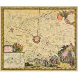
Military maps. De Pontault (Sebastien), Plan de la ville de Bourbour en Flandre assieg‚ par l'arm‚
Military maps. De Pontault (Sebastien), Plan de la ville de Bourbour en Flandre assieg‚ par l'arm‚e du Roy..., [and] Plan du Fort de Link assieg‚ ...
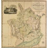
Monmouthshire. Greenwood (C. & H.), Map of the county of Monmouth, from an actual survey made in the
Monmouthshire. Greenwood (C. & H.), Map of the county of Monmouth, from an actual survey made in the years 1829 & 1830..., published August 23rd. ...
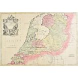
Netherlands. Senex (John), The VII United Provinces corrected from the observations communicated
Netherlands. Senex (John), The VII United Provinces corrected from the observations communicated to the Royal Society at London & ye Royal Academy...
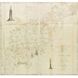
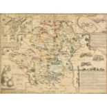
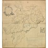
Northamptonshire. Eyre (Thomas & Jefferys Thomas), The county of Northampton as surveyed and
Northamptonshire. Eyre (Thomas & Jefferys Thomas), The county of Northampton as surveyed and planned..., 2nd edition, published William Faden, 179...
![Northamptonshire. Speed (John), Northampton, published Thomas Bassett & Richard Chiswell, [1676],](https://portal-images.azureedge.net/auctions-2018/srdom10120/images/9187f056-90b0-4167-849c-a9a801327862.jpg?w=155&h=155)
Northamptonshire. Speed (John), Northampton, published Thomas Bassett & Richard Chiswell, [1676],
Northamptonshire. Speed (John), Northampton, published Thomas Bassett & Richard Chiswell, [1676], hand coloured engraved map, inset town plans of ...

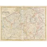
Northern England. A collection of twenty-two regional maps, 17th & 18th century, engraved regional
Northern England. A collection of twenty-two regional maps, 17th & 18th century, engraved regional maps of north east and north west England, incl...
![Northern England. Lamberti (Aniello), Carta II. per L'Inghilterra, published Florence, [1779],](https://portal-images.azureedge.net/auctions-2018/srdom10120/images/a4833203-54c5-4dd5-9d96-a9a801327995.jpg?w=155&h=155)
Northern England. Lamberti (Aniello), Carta II. per L'Inghilterra, published Florence, [1779],
Northern England. Lamberti (Aniello), Carta II. per L'Inghilterra, published Florence, [1779], engraved playing card map of the northern half of E...
Nottinghamshire. A collection of thirteen maps, 17th - 19th century, engraved maps, including
Nottinghamshire. A collection of thirteen maps, 17th - 19th century, engraved maps, including examples by Bowen, Morden, Saxton/Kip, Moll, Owen & ...
Ogilby (John). The Road from London to Harwich in Essex, The Road from London to Chichester in
Ogilby (John). The Road from London to Harwich in Essex, The Road from London to Chichester in com. Sussex, The Road from London to Weymouth com. ...
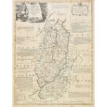
*Oxfordshire. Speed (John), Oxfordshire described with ye citie and the armes of the colledges of ye
*Oxfordshire. Speed (John), Oxfordshire described with ye citie and the armes of the colledges of ye famous university, published Thomas Bassett &...
![*Oxfordshire. Plot (Robert), The Map of Oxfordshire, [1677], hand coloured engraved map,](https://portal-images.azureedge.net/auctions-2018/srdom10120/images/8eb22ac9-0a0a-46c5-8b7b-a9a801327bb0.jpg?w=155&h=155)
*Oxfordshire. Plot (Robert), The Map of Oxfordshire, [1677], hand coloured engraved map, decorative cartouche, mileage scale, table of explanation...
![Persia. Ortelius (Abraham), Persici sive sophorum regni Typus, [1595], hand coloured engraved map,](https://portal-images.azureedge.net/auctions-2018/srdom10120/images/91f2de08-a973-48ef-a9e5-a9ac00db8e9e.jpg?w=155&h=155)
Persia. Ortelius (Abraham), Persici sive sophorum regni Typus, [1595], hand coloured engraved map,
Persia. Ortelius (Abraham), Persici sive sophorum regni Typus, [1595], hand coloured engraved map, slight fraying to margins but not affecting ima...
*Scotland. Scobie (Mathew), A map of Roxburgh Shire of Tiviotdale, circa 1770, large scale map
*Scotland. Scobie (Mathew), A map of Roxburgh Shire of Tiviotdale, circa 1770, large scale map with contemporary outline colouring, engraved by Jo...
Scotland Jaillot (Alexis Hubert & Bellin J. N.), Carte de la mer d'Ecosse contenant les Isles et
Scotland Jaillot (Alexis Hubert & Bellin J. N.), Carte de la mer d'Ecosse contenant les Isles et Costes septentrionales et occidentales d'Ecosse e...
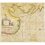
Sea charts. Van Keulen (Gerard), Pas caert Vande Zee-cussen van Engeland van Orfordnes tot den
Sea charts. Van Keulen (Gerard), Pas caert Vande Zee-cussen van Engeland van Orfordnes tot den Flamborger Hoost, published Amsterdam, circa 1780, ...
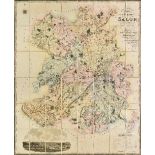
Shropshire. Greenwood (C. & J.), Map of the county of Salop from an actual survey made in the
Shropshire. Greenwood (C. & J.), Map of the county of Salop from an actual survey made in the years 1826 & 1827, published July 2nd. 1827, large s...
Society for the Diffusion of Useful Knowledge. A collection of eighteen city plans, circa 1840,
Society for the Diffusion of Useful Knowledge. A collection of eighteen city plans, circa 1840, engraved city plans with contemporary hand colouri...
Staffordshire, Derbyshire & Northamptonshire. A mixed collection of fourteen county maps, 17th -
Staffordshire, Derbyshire & Northamptonshire. A mixed collection of fourteen county maps, 17th - 19th century, engraved maps, including examples b...

*Sussex. Speed (John), Speed (John), Sussex described and divided into rapes with the situation of
*Sussex. Speed (John), Speed (John), Sussex described and divided into rapes with the situation of Chichester the cheife citie thereof and the arm...
![*Turkish Empire. Speed (John), The Turkish Empire, published George Humble, [1627], hand coloured](https://portal-images.azureedge.net/auctions-2018/srdom10120/images/f9a8e0a6-f4fe-4f64-b2f0-a9a801327fb6.jpg?w=155&h=155)
*Turkish Empire. Speed (John), The Turkish Empire, published George Humble, [1627], hand coloured
*Turkish Empire. Speed (John), The Turkish Empire, published George Humble, [1627], hand coloured engraved 'carte-a-figures' map, ten costumed fig...
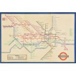
Underground map. Beck (Henry C.), London Underground Transport, 1937, colour photolithographic on
Underground map. Beck (Henry C.), London Underground Transport, 1937, colour photolithographic on card, an example of Beck's iconic map of the Lon...
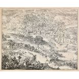
Vienna. De Hooghe (Romain), Untitled engraving of the siege of Vienna, published Amsterdam, Nicolas Visscher, circa 1685, uncoloured engraving, fa...
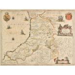
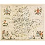
Wales. Jansson (Jan), Ceretica sive Cardiganensis comitatus Anglis Cardigan Shire, published
Wales. Jansson (Jan), Ceretica sive Cardiganensis comitatus Anglis Cardigan Shire, published Amsterdam, circa 1648, engraved map with contemporary...
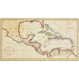
West Indies. A collection of approximately forty-five maps, mostly 18th & 19th century, engraved and
West Indies. A collection of approximately forty-five maps, mostly 18th & 19th century, engraved and lithographic maps of individual islands and t...
![*Wiltshire. Saxton (Christopher & Kip William), Wiltoniae comitatus herbida..., 1st edition, [1607],](https://portal-images.azureedge.net/auctions-2018/srdom10120/images/605922c4-1af7-47d1-b277-a9a80132830d.jpg?w=155&h=155)
*Wiltshire. Saxton (Christopher & Kip William), Wiltoniae comitatus herbida..., 1st edition, [1607],
*Wiltshire. Saxton (Christopher & Kip William), Wiltoniae comitatus herbida..., 1st edition, [1607], engraved map with contemporary outline colour...