Refine your search
Filtered by:
- Lots with images only,
- Sale Section
- List
- Grid
This auctioneer has chosen to not publish their results. Please contact them directly for any enquiries.


Africa. Homann (Johann Baptist, heirs of), Africa seceundum legitimas projectionis stereographicae
Africa. Homann (Johann Baptist, heirs of), Africa seceundum legitimas projectionis stereographicae regulas..., circa 1740, engraved map with conte...

Africa. Mercator (Gerard & Hondius Henricus), Africa Ex Magna Orbis Terre Descriptione Gerardi
Africa. Mercator (Gerard & Hondius Henricus), Africa Ex Magna Orbis Terre Descriptione Gerardi Mercatoris Desumpta Studio & Industria G.M. Juniori...

Americas. Homann (Johann Baptist, heirs of), Americae mappa generalis secundum legitimas projectionis stereo-graphicae regulas relationes..., Conc...

Americas. Laurie (Richard & Whittle James, publishers), A New Map of the Whole Continent of America.
Americas. Laurie (Richard & Whittle James, publishers), A New Map of the Whole Continent of America. Divided Into North and South and West Indies,...

Amsterdam. Senex (John), A new map of the city of Amsterdam most humbly inscrib'd to John Hedworth
Amsterdam. Senex (John), A new map of the city of Amsterdam most humbly inscrib'd to John Hedworth Esq., 1720, uncoloured city plan engraved by S....

Asia. Homann (Johann Baptist, heirs of), Asia secundum legitimas projectionis stereographicae
Asia. Homann (Johann Baptist, heirs of), Asia secundum legitimas projectionis stereographicae regulas et juxta recentissimas observation et relati...
![Asia. Ortelius (Abraham), Natoliae quae olim Asia minor nova descptio [on sheet with] Aegypti](https://portal-images.azureedge.net/auctions-2018/srdom10106/images/d3e16d25-d293-441f-86f6-0bce0b8b0436.jpg?w=155&h=155)
Asia. Ortelius (Abraham), Natoliae quae olim Asia minor nova descptio [on sheet with] Aegypti
Asia. Ortelius (Abraham), Natoliae quae olim Asia minor nova descptio [on sheet with] Aegypti recentior descriptio [and] Carthaginis celeberrimi s...

Asia. D'Anville (Jean Baptiste Bourguignon), Asia and its Islands..., divided into Empires, Kingdoms, States, Regions &c. with the European posses...

Belgium. Untitled plan of Veurne, circa 1686, pen, ink and watercolour cadastral plan of the land
Belgium. Untitled plan of Veurne, circa 1686, pen, ink and watercolour cadastral plan of the land outside the fortifications, old folds, occasiona...

Bourrut (Le Meri). Analyse G‚ographique des D‚partements de la France, 3rd. edition, published
Bourrut (Le Meri). Analyse G‚ographique des D‚partements de la France, 3rd. edition, published Paris, [1836], eighty-five of eighty-six (lacks num...

*British Islands. Jansson (Jan), Mona Insula vulgo Anglesy, Mona Insula vulgo The Isle of Man [
*British Islands. Jansson (Jan), Mona Insula vulgo Anglesy, Mona Insula vulgo The Isle of Man [and] Vectis Insula Anglice The Isle of Wight, publi...

*British Isles. Chatelain (H. A.), Nouvelle carte du Gouvernment Civil D'Angleterre et de celuy de
*British Isles. Chatelain (H. A.), Nouvelle carte du Gouvernment Civil D'Angleterre et de celuy de la Ville de Londres, published Amsterdam, circa...

British Isles. Bossuet (Jacques Benigne), Isles Britanniques, circa 1722, hand coloured engraved
British Isles. Bossuet (Jacques Benigne), Isles Britanniques, circa 1722, hand coloured engraved map, 130 x 165 mm, with another copy similar but ...

British Isles. Munster (Sebastian), Engellandt mit dem Anstossenden Reich Schottlandt so vor
British Isles. Munster (Sebastian), Engellandt mit dem Anstossenden Reich Schottlandt so vor Zeiten Albion und Britannia haben Geheissen, publishe...

British Isles. Mercator (Gerard), Tab. i Europae Continens Albion, Britanniam et Hiberniam..., [
British Isles. Mercator (Gerard), Tab. i Europae Continens Albion, Britanniam et Hiberniam..., [1695], uncoloured engraved map on a Ptolemaic proj...

British Isles. Merian (Matthaus), Magnae Britanniae et Hibernia Tabulae, circa 1650, hand coloured
British Isles. Merian (Matthaus), Magnae Britanniae et Hibernia Tabulae, circa 1650, hand coloured engraved map, inset map of the Orkney Islands, ...

British Isles. Jansson (Jan), Insularum Britannicarum acurata delineatio ex Geographicis conatibus
British Isles. Jansson (Jan), Insularum Britannicarum acurata delineatio ex Geographicis conatibus Abrahami Ortelii, published Amsterdam, [1646], ...

British Isles. Blaeu (Johannes), Britannia prout divisa suit temporibus Anglo-Saxonum praeserim
British Isles. Blaeu (Johannes), Britannia prout divisa suit temporibus Anglo-Saxonum praeserim durante illorum Heptarchia, published Amsterdam, c...

Cambridge. Lee (Kerry), Cambridge, published Pictorial Maps Ltd., circa 1946, colour printed
Cambridge. Lee (Kerry), Cambridge, published Pictorial Maps Ltd., circa 1946, colour printed decorative map, slight dust soiling to margins, 450 x...

Celestial Chart. Doppelmayer (Johann), Motus in coelo spirales quo planetae inferiores Venus et
Celestial Chart. Doppelmayer (Johann), Motus in coelo spirales quo planetae inferiores Venus et Mercurius..., published J. B. Homann, Nuremburg, c...

Chester. Braun (Georg & Hogenberg Franz), Cestria (vulgo) Chester Angliae civitas, [1581 or later], hand coloured engraved city plan, slight mount...
![Cologne. Braun (Georg & Hogenberg Frans),Colonia Agrippina..., [1572 or later], engraved city plan](https://portal-images.azureedge.net/auctions-2018/srdom10106/images/2ed8e199-956e-44f8-e35f-ce12b9208481.jpg?w=155&h=155)
Cologne. Braun (Georg & Hogenberg Frans),Colonia Agrippina..., [1572 or later], engraved city plan
Cologne. Braun (Georg & Hogenberg Frans),Colonia Agrippina..., [1572 or later], engraved city plan with contemporary hand colouring, 340 x 485 mm,...

Durham. Stratford (Bryan), An exact survey of the manor of Barnes in the county of Durham...,
Durham. Stratford (Bryan), An exact survey of the manor of Barnes in the county of Durham..., Anthony Ettricke Esquire, 1712, pen and watercolou...

East Indies. De L'Isle (Guillaume), Carte des Indes et de la Chine dres‚e sur plusiers relations
East Indies. De L'Isle (Guillaume), Carte des Indes et de la Chine dres‚e sur plusiers relations particulieres rectifi‚es par quelques observation...

East Indies. Homann (Johann Baptist, heirs of), Carte des Indes Orientales desin‚e suivant les
East Indies. Homann (Johann Baptist, heirs of), Carte des Indes Orientales desin‚e suivant les observations les plus recentes..., 1748, engraved m...

East Yorkshire. Page (Edward), Plan of Lands within the Jurisdiction of the Court of Sewers for
East Yorkshire. Page (Edward), Plan of Lands within the Jurisdiction of the Court of Sewers for the East parts of the East Riding of the County of...

England & Wales Sanson (Nicolas), Le Royaume D'Angleterre Distingu‚ en ses Provinces, published H.
England & Wales Sanson (Nicolas), Le Royaume D'Angleterre Distingu‚ en ses Provinces, published H. Jaillot, Paris, 1693, engraved map with contemp...

England & Wales. Cary (G. & J.), Cary's Improved Map of England and Wales with a considerable
England & Wales. Cary (G. & J.), Cary's Improved Map of England and Wales with a considerable portion of Scotland, planned upon a scale of two sta...

England & Wales. Berry (William), A New Mapp of the Kingdome of England and Wales Containing all the
England & Wales. Berry (William), A New Mapp of the Kingdome of England and Wales Containing all the Cities, Market Towns, with the Roades from To...

England & Wales. Coronelli (Vincenzo Maria), Parte settentrionale de Regno d'Inghilterra..., [
England & Wales. Coronelli (Vincenzo Maria), Parte settentrionale de Regno d'Inghilterra..., [together with] Parte meridionale del regno d'Inghilt...

England & Wales. Wallis (John), Wallis's Tour through England and Wales, A New Geographical Pastime,
England & Wales. Wallis (John), Wallis's Tour through England and Wales, A New Geographical Pastime, published 24th December 1794, engraved map wi...

England & Wales. Homann (Johann Baptist), Magnae Britanniae pars meridionalis in que Regnum Angliae tam in septem antiqua Anglo-Saxonum regna..., ...

*English Channel. Mortier (Pierre), Carte Nouvelle des costes D'Angleterre depuis la Rivi‚re de la
*English Channel. Mortier (Pierre), Carte Nouvelle des costes D'Angleterre depuis la Rivi‚re de la Tamise jusques a Portland & des Isles Voisines:...

English Channel. Seutter (Matth„us), La plus grande partie de la Manche, qui contient les c“tes D'
English Channel. Seutter (Matth„us), La plus grande partie de la Manche, qui contient les c“tes D'Angleterre et celles de France, les Bords Mariti...

Europe. Nieuwe Kaart van Europa 1870, Emrik & Binger (lithographers), 1870, hand coloured lithographic map, descriptive text in Dutch below map, t...

Europe. Lehmann-Dumont (Karl), Humoristische Karte von Europa im Jahre 1914, published Dresden,
Europe. Lehmann-Dumont (Karl), Humoristische Karte von Europa im Jahre 1914, published Dresden, 1914, colour printed photolithographic allegorical...

Europe. Hadol (Paul), Nouvelle Carte D'Europe dress‚e pour 1870, circa 1870, engraved map with
Europe. Hadol (Paul), Nouvelle Carte D'Europe dress‚e pour 1870, circa 1870, engraved map with contemporary hand colouring, old folds, one short s...

France & Italy. De L'Isle (Guillaume), Carte de Provence et des terres adjacentes, 1715, engraved
France & Italy. De L'Isle (Guillaume), Carte de Provence et des terres adjacentes, 1715, engraved map with contemporary outline colouring, some ma...
![France. Blaeu (Joannes), Thonon, published Amsterdam, [1682], large uncoloured engraved town plan on](https://portal-images.azureedge.net/auctions-2018/srdom10106/images/f55c6681-c995-4314-903f-31502337d7ab.jpg?w=155&h=155)
France. Blaeu (Joannes), Thonon, published Amsterdam, [1682], large uncoloured engraved town plan on
France. Blaeu (Joannes), Thonon, published Amsterdam, [1682], large uncoloured engraved town plan on two conjoined sheets, occasional marginal rep...

Globe. Malby's Terrestrial Globe. Compiled from the latest & most authentic sources including all
Globe. Malby's Terrestrial Globe. Compiled from the latest & most authentic sources including all the recent geographical discoveries, Edward Stan...

Globe. To be had of G.Pocock patentee, Bristol, Mr Pocock's Academy, Prospect Place, J. Vale
Globe. To be had of G.Pocock patentee, Bristol, Mr Pocock's Academy, Prospect Place, J. Vale fecit, Dec. 1838, an inflatable 30 inch (760 mm) pape...

Hampshire. Taylor (Isaac), Map of Hampshire, including the Isle of Wight, published August 20th,
Hampshire. Taylor (Isaac), Map of Hampshire, including the Isle of Wight, published August 20th, 1759, uncoloured engraved large scale map on si...

Hampshire. Speed (John), Hantshire described and devided, published John Sudbury & George Humble,
Hampshire. Speed (John), Hantshire described and devided, published John Sudbury & George Humble, 1st edition, [1611], hand coloured engraved map,...

Holy Land. Tirinius (Jacobus), Chorographia terrae Sanctae in Angustiorem Formam redacta et ex
Holy Land. Tirinius (Jacobus), Chorographia terrae Sanctae in Angustiorem Formam redacta et ex variis auctoribus a multis erroribus expurgata, pub...

Holy Land. Jansson (Jan), Situs Terrae Promissionis. S. S. Bibliorum intelligentiam exacte aperiens per Chr. Adrichom, published Amsterdam, circa ...

Holy Land. Ortelius (Abraham), Terra Sancta a Petro Laicstain perlustrata et ab eius ore et schedis a Christiano Schrot in tabulam redacta, [1584]...

Ireland. Ortelius (Abraham), Irlandiae accurata descriptio auctore Baptista Boazio, published J. B. Vrients, Antwerp circa 1612, engraved map wi...

Leeds. Thorp (Joshua & Martin S. D.), Map of the Country extending ten miles round Leeds, including Wakefield, Bradford, Dewsbury, Otley, Harewood...

London. Kelly's Directories (publishers), Kelly's Post Office Map of London, South Western Section, North Western Section, South Eastern Section [...

London. Smith (C.), Smith's New Map of London, circa 1853, engraved map with contemporary outline
London. Smith (C.), Smith's New Map of London, circa 1853, engraved map with contemporary outline colouring, sectionalised and laid on linen, slig...

London. Senex (John), A Plan of the citys of London, Westminster and borough of Southwark with the
London. Senex (John), A Plan of the citys of London, Westminster and borough of Southwark with the new additional buildings: Anno 1720, uncoloured...

London. Homann (Johann Baptist, heirs of), Urbium Londini et West-Monasterii nec non Suburbii
London. Homann (Johann Baptist, heirs of), Urbium Londini et West-Monasterii nec non Suburbii Southwark accurata Ichnographia..., published Nuremb...
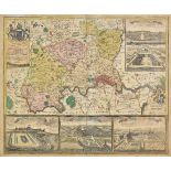
London. Homann (Johann Baptist), Accurater Grundriss u: Gegend der Koenigl: Gross-Brittanniscen
London. Homann (Johann Baptist), Accurater Grundriss u: Gegend der Koenigl: Gross-Brittanniscen Haupt und Residentz-Stadt London wie auch Prospect...
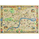
London. Stone (Laurence), Festival of Great Britain. News Chronicle Guide to London, published The
London. Stone (Laurence), Festival of Great Britain. News Chronicle Guide to London, published The News Chronicle, 1951, colour lithographic picto...
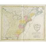
North America. Homann (Johann Baptist, heirs of), Charte uber die XIII vereinigte Staaten von Nord-
North America. Homann (Johann Baptist, heirs of), Charte uber die XIII vereinigte Staaten von Nord-America..., [1784], engraved map with contempo...
North East England. Mercator (Gerard & Hondius Henricus), Eboracum, Lincolnia, Derbia, Stafford
North East England. Mercator (Gerard & Hondius Henricus), Eboracum, Lincolnia, Derbia, Stafford etc., circa 1634, hand coloured engraved map, some...
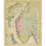
Norway. Homann (Johann Baptist, heirs of), Charte vom Koenigreich Norwegen..., published Nuremberg, 1789, engraved map with contemporary hand colo...
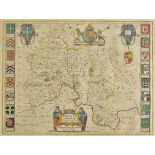
*Oxfordshire. Blaeu (Johannes), Oxonium comitatus vulgo Oxford Shire, published Amsterdam, circa
*Oxfordshire. Blaeu (Johannes), Oxonium comitatus vulgo Oxford Shire, published Amsterdam, circa 1645, engraved map with contemporary hand colouri...
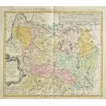
Poland & Lithuania. Homann (Johann Baptist, heirs of), Magn. Ducatus Lituaniae insvos palatinatus et
Poland & Lithuania. Homann (Johann Baptist, heirs of), Magn. Ducatus Lituaniae insvos palatinatus et districtus divisus..., published Nuremberg, 1...
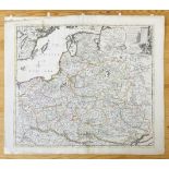
Poland. Senex (John), Poland and other the countries belonging to that crowne according to the
Poland. Senex (John), Poland and other the countries belonging to that crowne according to the newest observations, 1719, engraved map with contem...