Filtered by:
- Show only bulk lots,
- Category
- List
- Grid
This auctioneer has chosen to not publish their results. Please contact them directly for any enquiries.

Baedeker (Karl). Plans of London, Pl„ne von London, Plans de Londres, Plan-Anhang zu Berlin, Plans
Baedeker (Karl). Plans of London, Pl„ne von London, Plans de Londres, Plan-Anhang zu Berlin, Plans of Berlin, Pl„ne von Paris, Plans de Paris, Pla...
Barthelemy (Jean-Jacques). Recueil de cartes G‚ographiques, plans, vues et m‚dailles de l'ancienne
Barthelemy (Jean-Jacques). Recueil de cartes G‚ographiques, plans, vues et m‚dailles de l'ancienne Grece relatifs au voyage du jeune Anacharsis pr...
Bryce (James, et al). The International Atlas and Geography: Modern, Historical, Classical and
Bryce (James, et al). The International Atlas and Geography: Modern, Historical, Classical and Physical containing one hundred and thirty maps...,...
Carey (Henry Charles & Lea, Isaac). Family cabinet atlas, first American edition, revised, corrected
Carey (Henry Charles & Lea, Isaac). Family cabinet atlas, first American edition, revised, corrected and enlarged, Philadelphia, 1832, printed tit...
Cowley (John). A new and easy introduction to the study of geography by way of question and answer. Principally designed for the use of schools......
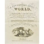
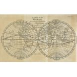
Dower (John). A new general atlas of the world, compiled from the latest authorities both English & foreign, containing separate maps of the vario...
Gordon (Patrick). Geography Anatomiz'd: or, The Geographical Grammar. Being a short and exact
Gordon (Patrick). Geography Anatomiz'd: or, The Geographical Grammar. Being a short and exact analysis of the whole body of modern geography, afte...
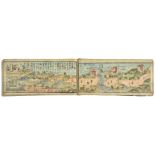
Japanese touring atlas. Fujitani (Toyushi), Dochu saiken joyado-cho (Route map and inn directory),
Japanese touring atlas. Fujitani (Toyushi), Dochu saiken joyado-cho (Route map and inn directory), Osaka, Fujiya Kikujiro, Kaei 4 (1851), miniatur...
Milner (Rev. Thomas & Petermann Augustus). A Descriptive Atlas of Astronomy and of Physical and
Milner (Rev. Thomas & Petermann Augustus). A Descriptive Atlas of Astronomy and of Physical and Political Geography, Wm. S. Orr and Co., 1850, fro...
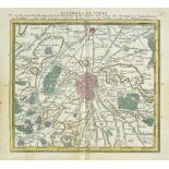
Paris. Desnos (Louis Charles), Almanach des environs de Paris, contenant la topographie de l'
Paris. Desnos (Louis Charles), Almanach des environs de Paris, contenant la topographie de l'Archevˆch‚ et des differens endroits du DiocŠse..., P...
Philip (George & Son, pub.). Philip's Handy volume atlas of the world, 1887, additional half title, sixty-four lithographic maps, index bound at r...
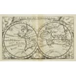
Remondi (publisher). Atlas G‚ographique dress‚ sur les meilleures cartes de ces derniers tems … l'
Remondi (publisher). Atlas G‚ographique dress‚ sur les meilleures cartes de ces derniers tems … l'usage des ecoles et de toute la jeunesse des deu...
Seller (John). Atlas Coelestis containing the systems and theoryes of the Planets the Constellations
Seller (John). Atlas Coelestis containing the systems and theoryes of the Planets the Constellations of the starrs and other phenominas of the hea...
Thomson (John). [A New General Atlas Consisting of a Series of Geographical Designs on Various
Thomson (John). [A New General Atlas Consisting of a Series of Geographical Designs on Various Projections Exhibiting the Form and Component Parts...
Bickham (George). The British Monarchy: Or a New Chorographical Description of all the Dominions
Bickham (George). The British Monarchy: Or a New Chorographical Description of all the Dominions Subject to the King of Great Britain. Comprehendi...

Harrison (John). Maps of the Different parts of the World: or a Complete Atlas upon a new and
Harrison (John). Maps of the Different parts of the World: or a Complete Atlas upon a new and Improved plan, with letter-press conveniently prefix...

Oliver (& Boyd, publishers). Oliver & Boyd's Travelling map of Scotland with the distances on the
Oliver (& Boyd, publishers). Oliver & Boyd's Travelling map of Scotland with the distances on the Great Roads upon a new and improved plan..., Edi...

Seller (John). Camden's Britannia abridg'd; the whole carefully perform'd and illustrated with above
Seller (John). Camden's Britannia abridg'd; the whole carefully perform'd and illustrated with above sixty maps exatly engraved..., printed by J. ...
Walpoole (George Augustus). The New British Traveller; or a complete modern universal dispay of
Walpoole (George Augustus). The New British Traveller; or a complete modern universal dispay of Great-Britain and Ireland, 1784, 19 engraved maps ...
Whittaker (G. & W. B. publishers). The Travellers Pocket Atlas consisting of a complete set of
Whittaker (G. & W. B. publishers). The Travellers Pocket Atlas consisting of a complete set of County Maps for England & Wales, 1st edition, 1823,...

Africa. Homann (Johann Baptist, heirs of), Africa seceundum legitimas projectionis stereographicae
Africa. Homann (Johann Baptist, heirs of), Africa seceundum legitimas projectionis stereographicae regulas..., circa 1740, engraved map with conte...

Africa. Mercator (Gerard & Hondius Henricus), Africa Ex Magna Orbis Terre Descriptione Gerardi
Africa. Mercator (Gerard & Hondius Henricus), Africa Ex Magna Orbis Terre Descriptione Gerardi Mercatoris Desumpta Studio & Industria G.M. Juniori...

Americas. Homann (Johann Baptist, heirs of), Americae mappa generalis secundum legitimas projectionis stereo-graphicae regulas relationes..., Conc...

Americas. Laurie (Richard & Whittle James, publishers), A New Map of the Whole Continent of America.
Americas. Laurie (Richard & Whittle James, publishers), A New Map of the Whole Continent of America. Divided Into North and South and West Indies,...

Amsterdam. Senex (John), A new map of the city of Amsterdam most humbly inscrib'd to John Hedworth
Amsterdam. Senex (John), A new map of the city of Amsterdam most humbly inscrib'd to John Hedworth Esq., 1720, uncoloured city plan engraved by S....

Asia. Homann (Johann Baptist, heirs of), Asia secundum legitimas projectionis stereographicae
Asia. Homann (Johann Baptist, heirs of), Asia secundum legitimas projectionis stereographicae regulas et juxta recentissimas observation et relati...
![Asia. Ortelius (Abraham), Natoliae quae olim Asia minor nova descptio [on sheet with] Aegypti](https://portal-images.azureedge.net/auctions-2018/srdom10106/images/d3e16d25-d293-441f-86f6-0bce0b8b0436.jpg?w=155&h=155)
Asia. Ortelius (Abraham), Natoliae quae olim Asia minor nova descptio [on sheet with] Aegypti
Asia. Ortelius (Abraham), Natoliae quae olim Asia minor nova descptio [on sheet with] Aegypti recentior descriptio [and] Carthaginis celeberrimi s...

Asia. D'Anville (Jean Baptiste Bourguignon), Asia and its Islands..., divided into Empires, Kingdoms, States, Regions &c. with the European posses...

Belgium. Untitled plan of Veurne, circa 1686, pen, ink and watercolour cadastral plan of the land
Belgium. Untitled plan of Veurne, circa 1686, pen, ink and watercolour cadastral plan of the land outside the fortifications, old folds, occasiona...
Belgium. Hogenberg (Frans), Episcopatus Leodiensis - Bisthumss Luttich Levesche De Liege, Namur
Belgium. Hogenberg (Frans), Episcopatus Leodiensis - Bisthumss Luttich Levesche De Liege, Namur cum Namur [and] Nobilis comitatus Hannoniae, circa...

Bourrut (Le Meri). Analyse G‚ographique des D‚partements de la France, 3rd. edition, published
Bourrut (Le Meri). Analyse G‚ographique des D‚partements de la France, 3rd. edition, published Paris, [1836], eighty-five of eighty-six (lacks num...

*British Islands. Jansson (Jan), Mona Insula vulgo Anglesy, Mona Insula vulgo The Isle of Man [
*British Islands. Jansson (Jan), Mona Insula vulgo Anglesy, Mona Insula vulgo The Isle of Man [and] Vectis Insula Anglice The Isle of Wight, publi...

*British Isles. Chatelain (H. A.), Nouvelle carte du Gouvernment Civil D'Angleterre et de celuy de
*British Isles. Chatelain (H. A.), Nouvelle carte du Gouvernment Civil D'Angleterre et de celuy de la Ville de Londres, published Amsterdam, circa...

British Isles. Bossuet (Jacques Benigne), Isles Britanniques, circa 1722, hand coloured engraved
British Isles. Bossuet (Jacques Benigne), Isles Britanniques, circa 1722, hand coloured engraved map, 130 x 165 mm, with another copy similar but ...

British Isles. Munster (Sebastian), Engellandt mit dem Anstossenden Reich Schottlandt so vor
British Isles. Munster (Sebastian), Engellandt mit dem Anstossenden Reich Schottlandt so vor Zeiten Albion und Britannia haben Geheissen, publishe...

British Isles. Mercator (Gerard), Tab. i Europae Continens Albion, Britanniam et Hiberniam..., [
British Isles. Mercator (Gerard), Tab. i Europae Continens Albion, Britanniam et Hiberniam..., [1695], uncoloured engraved map on a Ptolemaic proj...

British Isles. Merian (Matthaus), Magnae Britanniae et Hibernia Tabulae, circa 1650, hand coloured
British Isles. Merian (Matthaus), Magnae Britanniae et Hibernia Tabulae, circa 1650, hand coloured engraved map, inset map of the Orkney Islands, ...

British Isles. Jansson (Jan), Insularum Britannicarum acurata delineatio ex Geographicis conatibus
British Isles. Jansson (Jan), Insularum Britannicarum acurata delineatio ex Geographicis conatibus Abrahami Ortelii, published Amsterdam, [1646], ...

British Isles. Blaeu (Johannes), Britannia prout divisa suit temporibus Anglo-Saxonum praeserim
British Isles. Blaeu (Johannes), Britannia prout divisa suit temporibus Anglo-Saxonum praeserim durante illorum Heptarchia, published Amsterdam, c...

Cambridge. Lee (Kerry), Cambridge, published Pictorial Maps Ltd., circa 1946, colour printed
Cambridge. Lee (Kerry), Cambridge, published Pictorial Maps Ltd., circa 1946, colour printed decorative map, slight dust soiling to margins, 450 x...

Celestial Chart. Doppelmayer (Johann), Motus in coelo spirales quo planetae inferiores Venus et
Celestial Chart. Doppelmayer (Johann), Motus in coelo spirales quo planetae inferiores Venus et Mercurius..., published J. B. Homann, Nuremburg, c...

Chester. Braun (Georg & Hogenberg Franz), Cestria (vulgo) Chester Angliae civitas, [1581 or later], hand coloured engraved city plan, slight mount...
![Cologne. Braun (Georg & Hogenberg Frans),Colonia Agrippina..., [1572 or later], engraved city plan](https://portal-images.azureedge.net/auctions-2018/srdom10106/images/2ed8e199-956e-44f8-e35f-ce12b9208481.jpg?w=155&h=155)
Cologne. Braun (Georg & Hogenberg Frans),Colonia Agrippina..., [1572 or later], engraved city plan
Cologne. Braun (Georg & Hogenberg Frans),Colonia Agrippina..., [1572 or later], engraved city plan with contemporary hand colouring, 340 x 485 mm,...
Coronelli (Vincenzo Maria). Cambridge, Norwich latinis Nordoucum, Nordwich capitale de contado si
Coronelli (Vincenzo Maria). Cambridge, Norwich latinis Nordoucum, Nordwich capitale de contado si Norfolck, Rochester latinis Roffa, Canterbury la...

Durham. Stratford (Bryan), An exact survey of the manor of Barnes in the county of Durham...,
Durham. Stratford (Bryan), An exact survey of the manor of Barnes in the county of Durham..., Anthony Ettricke Esquire, 1712, pen and watercolou...

East Indies. De L'Isle (Guillaume), Carte des Indes et de la Chine dres‚e sur plusiers relations
East Indies. De L'Isle (Guillaume), Carte des Indes et de la Chine dres‚e sur plusiers relations particulieres rectifi‚es par quelques observation...

East Indies. Homann (Johann Baptist, heirs of), Carte des Indes Orientales desin‚e suivant les
East Indies. Homann (Johann Baptist, heirs of), Carte des Indes Orientales desin‚e suivant les observations les plus recentes..., 1748, engraved m...

East Yorkshire. Page (Edward), Plan of Lands within the Jurisdiction of the Court of Sewers for
East Yorkshire. Page (Edward), Plan of Lands within the Jurisdiction of the Court of Sewers for the East parts of the East Riding of the County of...

England & Wales Sanson (Nicolas), Le Royaume D'Angleterre Distingu‚ en ses Provinces, published H.
England & Wales Sanson (Nicolas), Le Royaume D'Angleterre Distingu‚ en ses Provinces, published H. Jaillot, Paris, 1693, engraved map with contemp...
England & Wales. Rocque (John), England and Wales Drawn from the Most Accurate Surveys, containing
England & Wales. Rocque (John), England and Wales Drawn from the Most Accurate Surveys, containing all the Cities, Boroughs, Market Towns & Villag...

England & Wales. Cary (G. & J.), Cary's Improved Map of England and Wales with a considerable
England & Wales. Cary (G. & J.), Cary's Improved Map of England and Wales with a considerable portion of Scotland, planned upon a scale of two sta...

England & Wales. Berry (William), A New Mapp of the Kingdome of England and Wales Containing all the
England & Wales. Berry (William), A New Mapp of the Kingdome of England and Wales Containing all the Cities, Market Towns, with the Roades from To...

England & Wales. Coronelli (Vincenzo Maria), Parte settentrionale de Regno d'Inghilterra..., [
England & Wales. Coronelli (Vincenzo Maria), Parte settentrionale de Regno d'Inghilterra..., [together with] Parte meridionale del regno d'Inghilt...

England & Wales. Wallis (John), Wallis's Tour through England and Wales, A New Geographical Pastime,
England & Wales. Wallis (John), Wallis's Tour through England and Wales, A New Geographical Pastime, published 24th December 1794, engraved map wi...

England & Wales. Homann (Johann Baptist), Magnae Britanniae pars meridionalis in que Regnum Angliae tam in septem antiqua Anglo-Saxonum regna..., ...

*English Channel. Mortier (Pierre), Carte Nouvelle des costes D'Angleterre depuis la Rivi‚re de la
*English Channel. Mortier (Pierre), Carte Nouvelle des costes D'Angleterre depuis la Rivi‚re de la Tamise jusques a Portland & des Isles Voisines:...

English Channel. Seutter (Matth„us), La plus grande partie de la Manche, qui contient les c“tes D'
English Channel. Seutter (Matth„us), La plus grande partie de la Manche, qui contient les c“tes D'Angleterre et celles de France, les Bords Mariti...

Europe. Nieuwe Kaart van Europa 1870, Emrik & Binger (lithographers), 1870, hand coloured lithographic map, descriptive text in Dutch below map, t...

Europe. Lehmann-Dumont (Karl), Humoristische Karte von Europa im Jahre 1914, published Dresden,
Europe. Lehmann-Dumont (Karl), Humoristische Karte von Europa im Jahre 1914, published Dresden, 1914, colour printed photolithographic allegorical...

Europe. Hadol (Paul), Nouvelle Carte D'Europe dress‚e pour 1870, circa 1870, engraved map with
Europe. Hadol (Paul), Nouvelle Carte D'Europe dress‚e pour 1870, circa 1870, engraved map with contemporary hand colouring, old folds, one short s...