Refine your search
Sale Section
Remove filter- Antiquarian (116)
- Art Reference (9)
- Black's Colour Guides (6)
- Bookbinding Equipment, Tools and Reference Books (30)
- British Bee Books (10)
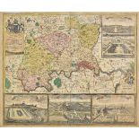
- British Topography (51)
- Decorative Prints and Original Art (32)
- Fine Bindings (21)
- General Literature (40)
- Historical Documents, Autographs and Ephemera (21)
- Maps (102)
- Natural History (14)
- Periodicals (8)
- Quantity (87)
- Travel and Exploration (39)
Estimate
Category
- Books & Periodicals (378)
- Maps (124)
- Prints (45)
- Metalware (8)
- Collectables (7)
- Furniture (5)
- Arms, Armour & Militaria (3)
- Models, Toys, Dolls & Games (3)
- Tools (3)
- Watercolours (3)
- Sporting Memorabilia & Equipment (2)
- Ceramics (1)
- Islamic Works of Art (1)
- Musical Instruments & Memorabilia (1)
- Salvage & Architectural Antiques (1)
- Scientific Instruments (1)
Filtered by:
- Sale Section
- List
- Grid
This auctioneer has chosen to not publish their results. Please contact them directly for any enquiries.

London. Homann (Johann Baptist), Accurater Grundriss u: Gegend der Koenigl: Gross-Brittanniscen
London. Homann (Johann Baptist), Accurater Grundriss u: Gegend der Koenigl: Gross-Brittanniscen Haupt und Residentz-Stadt London wie auch Prospect...
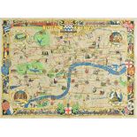
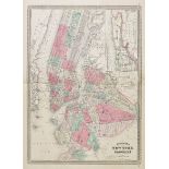
London. Stone (Laurence), Festival of Great Britain. News Chronicle Guide to London, published The
London. Stone (Laurence), Festival of Great Britain. News Chronicle Guide to London, published The News Chronicle, 1951, colour lithographic picto...
*Manuscript map. A Plan of Pentre-bach farm the property of Mr Edw. Thomas. Graweth farm the
*Manuscript map. A Plan of Pentre-bach farm the property of Mr Edw. Thomas. Graweth farm the property of Rydybiw(?) Chapel & part of Mr Wm. David'...
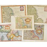
Maps. A mixed collection of approximately 250 maps, mostly 19th century, engraved and lithographic
Maps. A mixed collection of approximately 250 maps, mostly 19th century, engraved and lithographic British and foreign maps, including examples by...
Netherlands. Blaeu (Willem), Zeelandia comitatus, circa 1640, engraved map with contemporary hand
Netherlands. Blaeu (Willem), Zeelandia comitatus, circa 1640, engraved map with contemporary hand colouring, compass rose and numerous rhumb lines...
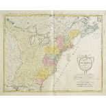
North America. Homann (Johann Baptist, heirs of), Charte uber die XIII vereinigte Staaten von Nord-
North America. Homann (Johann Baptist, heirs of), Charte uber die XIII vereinigte Staaten von Nord-America..., [1784], engraved map with contempo...
North East England. Mercator (Gerard & Hondius Henricus), Eboracum, Lincolnia, Derbia, Stafford
North East England. Mercator (Gerard & Hondius Henricus), Eboracum, Lincolnia, Derbia, Stafford etc., circa 1634, hand coloured engraved map, some...
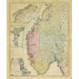
Norway. Homann (Johann Baptist, heirs of), Charte vom Koenigreich Norwegen..., published Nuremberg, 1789, engraved map with contemporary hand colo...
*Oxfordshire. Blaeu (Johannes), Oxonium comitatus vulgo Oxford Shire, published Amsterdam, circa
*Oxfordshire. Blaeu (Johannes), Oxonium comitatus vulgo Oxford Shire, published Amsterdam, circa 1645, engraved map with contemporary hand colouri...
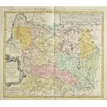
Poland & Lithuania. Homann (Johann Baptist, heirs of), Magn. Ducatus Lituaniae insvos palatinatus et
Poland & Lithuania. Homann (Johann Baptist, heirs of), Magn. Ducatus Lituaniae insvos palatinatus et districtus divisus..., published Nuremberg, 1...
Poland. Senex (John), Poland and other the countries belonging to that crowne according to the
Poland. Senex (John), Poland and other the countries belonging to that crowne according to the newest observations, 1719, engraved map with contem...
Portugal. Rossi (Giacomo G.), Il Regno di Portogallo..., 1692, uncoloured map of Southern Portugal, engraved by Antonio Barbey, slight staining, 4...
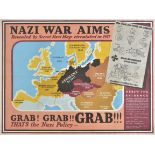
Propaganda Map. Nazi War Aims. Grab! Grab! Grab! circa 1940, British propaganda map of Europe, old
Propaganda Map. Nazi War Aims. Grab! Grab! Grab! circa 1940, British propaganda map of Europe, old folds strengthened on verso, 375 x 495 mm (1)...
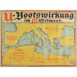
Propaganda maps. U-Bootswirkung im Mittelmeer, published German Admiralty, circa 1918, colour
Propaganda maps. U-Bootswirkung im Mittelmeer, published German Admiralty, circa 1918, colour lithographic World War I German propaganda poster sh...
![Prussia. Homann (Johann Baptist, heirs of), Borussiae occidentalis tabuls [and] Tabula regni](https://portal-images.azureedge.net/auctions-2018/srdom10106/images/0b9b1222-3da9-4fe6-a570-1e5dc931c39b.jpg?w=155&h=155)
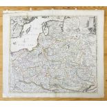
Prussia. Homann (Johann Baptist, heirs of), Borussiae occidentalis tabuls [and] Tabula regni
Prussia. Homann (Johann Baptist, heirs of), Borussiae occidentalis tabuls [and] Tabula regni Borussiae Borussiam orientalem exhibens, published Nu...
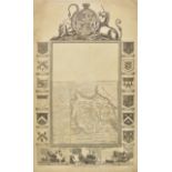
![Rome. Senex (John), A new mapp of Rome shewing its antient and present scituation, [1721],](https://portal-images.azureedge.net/auctions-2018/srdom10106/images/6164fa35-1178-4b83-db56-a826bc573c1b.jpg?w=155&h=155)
Rome. Senex (John), A new mapp of Rome shewing its antient and present scituation, [1721], uncoloured map engraved by J. Harris, inset keys identi...
Russia. Homann (Johann Baptist, heirs of), Ingermanlandiae seu Ingriae novissima tabula luci
Russia. Homann (Johann Baptist, heirs of), Ingermanlandiae seu Ingriae novissima tabula luci tradita, 1734, engraved map with contemporary hand co...
Russia. Homann (Johann Baptist, heirs of), Charte von Russisch Litauen welche die von Polan an
Russia. Homann (Johann Baptist, heirs of), Charte von Russisch Litauen welche die von Polan an Russland..., published Nuremberg, 1775, engraved ma...
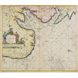
Scilly Isles. Laurie (Robert & Whittle James), A Chart of the Chops of the Channel to the South of
Scilly Isles. Laurie (Robert & Whittle James), A Chart of the Chops of the Channel to the South of the Scilly Islands, containing the west Coast o...
Scotland. Blaeu (Johannes), Scotia Regnum cum insulis adjacentibus Robertus Gordonius a Straloch
Scotland. Blaeu (Johannes), Scotia Regnum cum insulis adjacentibus Robertus Gordonius a Straloch descripsit, published Amsterdam, circa 1654, two ...
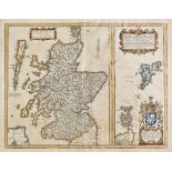
Scotland. Lewis (Samuel, publisher), A Map of Scotland divided into Counties shewing the principal
Scotland. Lewis (Samuel, publisher), A Map of Scotland divided into Counties shewing the principal roads, railways, rivers, canals, lochs, mountai...
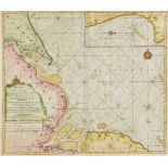
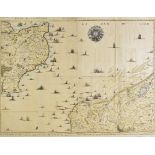
Sea chart. Van Keulen (Johannes), Nieuwe Paskaert vande oost cust van Engeland en Schotland.
Sea chart. Van Keulen (Johannes), Nieuwe Paskaert vande oost cust van Engeland en Schotland. Beginnende van t'Flamburger Hoost tot aan de Rivier v...
Sea chart. Van Keulen (Johannes), Pas-caert van de Zee-cussen van Engeland van Orfordnes tot den
Sea chart. Van Keulen (Johannes), Pas-caert van de Zee-cussen van Engeland van Orfordnes tot den Flamborger Hoost, t'Amsterdam by Joannes van Keul...
Sea chart. Van Keulen (Gerard), A New - Enereasing Compass Map of part of the East-Coast of England;
Sea chart. Van Keulen (Gerard), A New - Enereasing Compass Map of part of the East-Coast of England; extending from Eckles to Flamborough-Head; co...
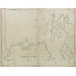
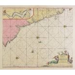
Sea chart. The Approaches to the Firth of Clyde, published James Imray & Son, 1854, additions to
Sea chart. The Approaches to the Firth of Clyde, published James Imray & Son, 1854, additions to 1859, large uncoloured engraved 'blue-backed' sea...
Sea charts. A mixed collection of twenty-one sea charts, mostly 20th century, printed English &
Sea charts. A mixed collection of twenty-one sea charts, mostly 20th century, printed English & French sea charts, including maps of Australia, So...
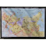
Soviet Union. Sowjetunion u. Mongolische VR Bodensch„tze u. Industrie, published Leipzig, circa
Soviet Union. Sowjetunion u. Mongolische VR Bodensch„tze u. Industrie, published Leipzig, circa 1970, very large map printed in colours, slight ...
Straits of Dover. Fricx (Eugene Henri), Partie de L'Angleterre, Les Costes du Boulenois et le Pas de
Straits of Dover. Fricx (Eugene Henri), Partie de L'Angleterre, Les Costes du Boulenois et le Pas de Calais [and] Carte particuliere des environs ...
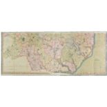
Suffolk. Bryant (Andrew), Map of the County of Suffolk from actual survey..., in the years 1824
Suffolk. Bryant (Andrew), Map of the County of Suffolk from actual survey..., in the years 1824 and 1825, published March 1st. 1826, large scale e...
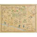
Sussex. Hands (Freda), Untitled manuscript map of East Sussex and the South Downs, 1938, decorative allegorical map in pen and watercolour, signed...
United States. A mixed collection of sixteen state and regional maps circa 1860, engraved state,
United States. A mixed collection of sixteen state and regional maps circa 1860, engraved state, city plan and regional maps, with examples by Joh...
*World. Twydell (T.), A Map of the World, Lincoln, 1812, large decorative manuscript pen and wash
*World. Twydell (T.), A Map of the World, Lincoln, 1812, large decorative manuscript pen and wash hemispheral map of the world, dust soiled and cr...
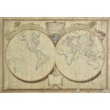
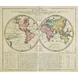
World. Lotter (Mathais Albrecht), Mappe Monde ou Carte Generale de l'univers sur une projection
World. Lotter (Mathais Albrecht), Mappe Monde ou Carte Generale de l'univers sur une projection nouvelle d'une sphere ovale..., avec le tour du mo...
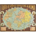
World. Tutte le Strade Conducono, published Rome, 1929, chromolithographic map, old folds, some
World. Tutte le Strade Conducono, published Rome, 1929, chromolithographic map, old folds, some fraying and wear to folds and margins, contemporar...
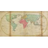
World. Homann (Johann Baptist, heirs of), Neue Welt-Karte welche auf zwoo kugelflaechen die haupt-
World. Homann (Johann Baptist, heirs of), Neue Welt-Karte welche auf zwoo kugelflaechen die haupt-theile der Erde, Inseln, Insel-Gruppen, Theile d...
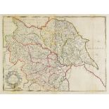
Yorkshire. A mixed collection of twenty-one maps, 18th century, including Badeslade (Thomas & Toms
Yorkshire. A mixed collection of twenty-one maps, 18th century, including Badeslade (Thomas & Toms W. H.), A Map of Yorkshire, published Champante...
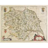
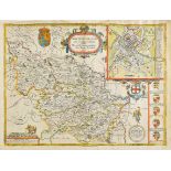
Yorkshire. Blaeu (Johannes), Ducatus Eboracensis Anglice York Shire, published Amsterdam, circa
Yorkshire. Blaeu (Johannes), Ducatus Eboracensis Anglice York Shire, published Amsterdam, circa 1645, engraved map with contemporary hand colourin...
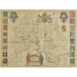
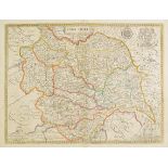
Yorkshire. Saxton (Christopher & Lea Philip), York-Shire described by Ch. Saxton. Many additions and
Yorkshire. Saxton (Christopher & Lea Philip), York-Shire described by Ch. Saxton. Many additions and corrections as ye Roads, Wapontakes &c. by. P...
Yorkshire. Speed (John), The West Ridinge of Yorkshyre with the most famous and fayre citie Yorke
Yorkshire. Speed (John), The West Ridinge of Yorkshyre with the most famous and fayre citie Yorke described, published John Sudbury & George Humbl...
Yorkshire. Speed (John), York Shire, published Christopher Brown, sold by Henry Overton, circa 1713,
Yorkshire. Speed (John), York Shire, published Christopher Brown, sold by Henry Overton, circa 1713, engraved map with contemporary outline colour...
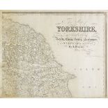
Yorkshire. Hobson (William Colling), This Map of Yorkshire is most respectfully dedicated to the
Yorkshire. Hobson (William Colling), This Map of Yorkshire is most respectfully dedicated to the nobility, clergy, gentry, landowners and manufact...
Yorkshire. Hobson (William Colling), This Map of Yorkshire is most respectfully dedicated to the
Yorkshire. Hobson (William Colling), This Map of Yorkshire is most respectfully dedicated to the nobility, clergy, gentry, landowners and manufact...
*Albert (Prince Consort, 1819-1861). Scene from Goethe's 'Gotz von Berlichingen', 1841, uncoloured
*Albert (Prince Consort, 1819-1861). Scene from Goethe's 'Gotz von Berlichingen', 1841, uncoloured etching on india, etched signature and date ins...
*Brighton. Wallis (Arthur), A Perspective View of Brighthelmstone and of the Sea Coast as far as the
*Brighton. Wallis (Arthur), A Perspective View of Brighthelmstone and of the Sea Coast as far as the Isle of Wight..., published Brighton, circa 1...
*British topographical views. A mixed collection of approximately 175 prints and engravings,
*British topographical views. A mixed collection of approximately 175 prints and engravings, 18th & 19th century, engravings and lithographs, incl...
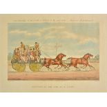
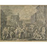
*Coaching. Harris (John), Car Travelling in the South of Ireland in the year 1856, Bianconi Establishment, published Ackermann & Co., December 1st...
*Cock Fighting. The Set-to [and] The Victory, published R. Ackermann circa 1820 [but later impressions], hand coloured aquatints after Edwin Coope...
![*[Dickens, Charles]. A collection of four original drawings of characters from Dickens's novels, mid](https://portal-images.azureedge.net/auctions-2018/srdom10106/images/f05a74f0-1285-4212-89d7-ba2ba4f42313.jpg?w=155&h=155)
*[Dickens, Charles]. A collection of four original drawings of characters from Dickens's novels, mid
*[Dickens, Charles]. A collection of four original drawings of characters from Dickens's novels, mid 20th century, together four watercolours, e...
*Edridge (Henry, 1769-1821). Portrait of Lady Mary Lennox (1740-1796), Duchess of Richmond, daughter
*Edridge (Henry, 1769-1821). Portrait of Lady Mary Lennox (1740-1796), Duchess of Richmond, daughter of Charles Bruce, Earl of Ailesbury, fine pe...
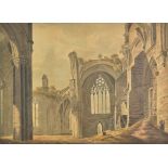
*English school. Abbey ruins with figures, early 19th century, watercolour on board, showing figures
*English school. Abbey ruins with figures, early 19th century, watercolour on board, showing figures undertaking repairs to the abbey walls, shor...
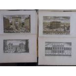
*France. A collection of thirty-nine engravings, circa 1750, engraved topographical views, showing
*France. A collection of thirty-nine engravings, circa 1750, engraved topographical views, showing gardens, palaces and stately homes, thirty-two ...
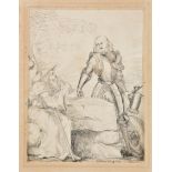
![*Hogarth (William). The Invasion, France Plate 1st [and] The Invasion, England Plate 2d, 1756,](https://portal-images.azureedge.net/auctions-2018/srdom10106/images/d9dcb7ea-031e-4ec0-df21-5411d9d42b63.jpg?w=155&h=155)
*Hogarth (William). The Invasion, France Plate 1st [and] The Invasion, England Plate 2d, 1756,
*Hogarth (William). The Invasion, France Plate 1st [and] The Invasion, England Plate 2d, 1756, pair of uncoloured etchings, slight spotting, each ...
*Hogarth (William). A representation of the march of the guards towards Scotland in the year 1745,
*Hogarth (William). A representation of the march of the guards towards Scotland in the year 1745, 1761 (or slightly later), uncoloured engraving ...
*Holy Land. Chatelain (Henry Abraham), Vue & description de la ville de Jerusalem telle qu'elle
*Holy Land. Chatelain (Henry Abraham), Vue & description de la ville de Jerusalem telle qu'elle est aujourd'hui avec les tombeaux de ses anciens R...

*Ipswich. Two prospects of Ipswich, circa 1850, two uncoloured lithographs, each mounted to image
*Ipswich. Two prospects of Ipswich, circa 1850, two uncoloured lithographs, each mounted to image with separate mount aperture for title, each app...
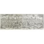
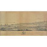
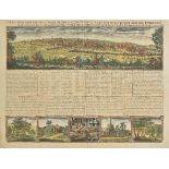
*Istanbul. Probst (George Bathasar), Constantinopolis, published Augsburg, circa 1760, uncoloured
*Istanbul. Probst (George Bathasar), Constantinopolis, published Augsburg, circa 1760, uncoloured engraved panorama after F. B. Werner on two conj...
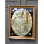
*After Angelica Kauffman (1741-1807). Fame Decorating Shakespeare's Tomb, late 17th/early 18th
*After Angelica Kauffman (1741-1807). Fame Decorating Shakespeare's Tomb, late 17th/early 18th century, fine embroidered and painted picture on c...
*Lemurs. Grandidier (Alfred, publisher), A collection of approximately sixty-five lithographs,
*Lemurs. Grandidier (Alfred, publisher), A collection of approximately sixty-five lithographs, originally published in 'Histoire Physique, Naturel...
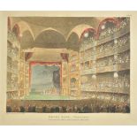
*London. A collection of twenty-nine engravings originally published in Ackermann's 'Microcosm of
*London. A collection of twenty-nine engravings originally published in Ackermann's 'Microcosm of London', [1808 - 1810], aquatints after Rowlands...
*London. Shotter Boys (Thomas), The Club Houses &c. Pall Mall, Piccadilly looking towards the
*London. Shotter Boys (Thomas), The Club Houses &c. Pall Mall, Piccadilly looking towards the City [and] the Tower and Mint looking from Great Tow...