Refine your search
Sale Section
Remove filter- British Topography (4)
- Maps (81)
- Travel and Exploration (6)
Estimate
Category
Remove filter- Maps (91)
Filtered by:
- Sale Section,
- Category
- List
- Grid
A subscription to the Price Guide is required to view results for auctions ten days or older. Click here for more information

Anson (George). Reize Rondsom de Werreld, Gedaan in de Jaaren 1740 tot 1744..., opgesteld uit de
Anson (George). Reize Rondsom de Werreld, Gedaan in de Jaaren 1740 tot 1744..., opgesteld uit de journaalen en andere papieren van de Hoog Ed. Geo...
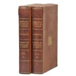
Cellarius (Christopher). Geographia Antiqua: Being a complete set of maps of ancient geography...,
Cellarius (Christopher). Geographia Antiqua: Being a complete set of maps of ancient geography..., published B. Law and F. & C. Rivington, 1796, d...
Faden (William, publisher). Atlas Minimus Universalis, or A Geographical Abridgement Ancient and
Faden (William, publisher). Atlas Minimus Universalis, or A Geographical Abridgement Ancient and Modern of the several parts of the earth in fifty...
Fisquet (Honore Jean Pierre). Grand Atlas D‚partemental de la France de l'Alg‚rie et des Colonies, 2
Fisquet (Honore Jean Pierre). Grand Atlas D‚partemental de la France de l'Alg‚rie et des Colonies, 2 volumes, published Paris: A. Le Vasseur, [187...
Gordon (Patrick). Geography Anatomiz'd: or, The Geographical Grammar. Being a short and exact
Gordon (Patrick). Geography Anatomiz'd: or, The Geographical Grammar. Being a short and exact analysis of the whole body of modern geography, afte...
![Sharpe (John, publisher). [Sharpe's Corresponding Atlas], Chapman & Hall, circa 1850, lacking](https://portal-images.azureedge.net/auctions-2018/srdom10105/images/fada27fe-9580-4eae-8d4e-41e77ca6c238.jpg?w=155&h=155)
Sharpe (John, publisher). [Sharpe's Corresponding Atlas], Chapman & Hall, circa 1850, lacking
Sharpe (John, publisher). [Sharpe's Corresponding Atlas], Chapman & Hall, circa 1850, lacking title and preliminaries, fifty-three maps (only), er...
Cary (John). Cary's Traveller's Companion or a Delineation of the Turnpike Roads of England and
Cary (John). Cary's Traveller's Companion or a Delineation of the Turnpike Roads of England and Wales..., [1792 or later], printed title trimmed w...
Cole (George & Roper, John). The British Atlas; Comprising a complete set of County Maps of England and Wales with a general map of navigable Rive...
Phillips (Richard, pub.). An Atlas of the British Islands containing forty-six maps newly and
Phillips (Richard, pub.). An Atlas of the British Islands containing forty-six maps newly and originally drawn from the population returns and oth...
Tunnicliff (William). A Topographical Survey of the Counties of Stafford, Chester and Lancaster,
Tunnicliff (William). A Topographical Survey of the Counties of Stafford, Chester and Lancaster, containing a new-engraved map of each county..., ...
Africa. Munster (Sebastian), Tavola & discrizzione universale di tutta l'Africa distesa anche piu la
Africa. Munster (Sebastian), Tavola & discrizzione universale di tutta l'Africa distesa anche piu la che i termini di Tolomeo, published Basle, ci...
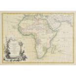
Africa. Janvier (Jean) L'Afrique divis‚e en ses principaux etats, published Paris, 1762, engraved
Africa. Janvier (Jean) L'Afrique divis‚e en ses principaux etats, published Paris, 1762, engraved map with contemporary outline colouring, slight ...
*Americas. Gentleman's Magazine (publisher), A Map of the Country between Crown Point and Fort
*Americas. Gentleman's Magazine (publisher), A Map of the Country between Crown Point and Fort Edward, [1759], uncoloured engraved map, 190 x 115...
Andrews (John and Dury, Andrew). A Map of the Country sixty-five miles round London from actual
Andrews (John and Dury, Andrew). A Map of the Country sixty-five miles round London from actual surveys..., published J. Stoke, 1777, four (only) ...
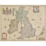
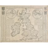
British Isles. Helvicus (Nicholaus / Custodis David), Angliae Scotiae et Hiberniae sive Britannicarum Insularum, [1644], uncoloured engraved map o...
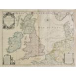
British Isles. Inselin (Charles), Carte des Royaumes D'Angleterre, D'Ecosse et D'Irlande...,
British Isles. Inselin (Charles), Carte des Royaumes D'Angleterre, D'Ecosse et D'Irlande..., published Paris, Alexis-Hubert Jaillot, 1715, large e...
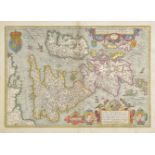
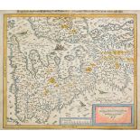
British Isles. Jansson (Jan), Angliae, Scotiae et Hiberniae sive Britannicar: Insularum descriptio, published Amsterdam, circa 1630, hand coloured...
British Isles. Munster (Sebastian), Engellandt mit dem anstossenden Reich Schottlandt so vor
British Isles. Munster (Sebastian), Engellandt mit dem anstossenden Reich Schottlandt so vor zeiten Albion und Britannia haben geheissen, publishe...
British Isles. Jansson (Jan), Magnae Britanniae et Hiberniae nova descriptio, circa 1646, engraved
British Isles. Jansson (Jan), Magnae Britanniae et Hiberniae nova descriptio, circa 1646, engraved map with contemporary outline colouring, inset ...
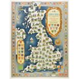
*British Isles. National Savings Committee (publishers), National Savings Map of the British Isles
*British Isles. National Savings Committee (publishers), National Savings Map of the British Isles showing Festivals and Customs and the Arms or S...
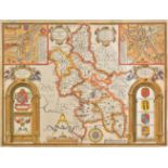
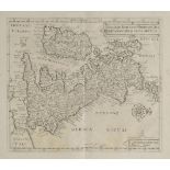
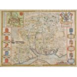
Buckinghamshire. Speed (John), Buckingham both Shyre and Shire towne describ., 1st. edition,
Buckinghamshire. Speed (John), Buckingham both Shyre and Shire towne describ., 1st. edition, published George Humble, [1611], hand coloured engrav...
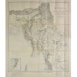
Burma. Philip (George & Son, publisher), Burma and adjacent countries, published under the direction
Burma. Philip (George & Son, publisher), Burma and adjacent countries, published under the direction of Col. H. R. Thuillier R. E., Surveyor Gener...
Chatelain (Henri Abraham). Nouvelle Carte D'Angleterre, D'Ecosse et D'Irlande avec des Instructions pour Connoitre Les Differents Etats de la Cour...
Doncaster. Faden (William & Sheardon, William, pubs.), To the Right Honourable William Wentworth
Doncaster. Faden (William & Sheardon, William, pubs.), To the Right Honourable William Wentworth Fitzwilliam, Earl of Fitzwilliam, Viscount and Ba...
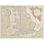
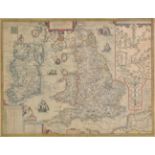
England & Wales. Visscher (Nicolas), A New Mapp of the Kingdome of England, Representing the
England & Wales. Visscher (Nicolas), A New Mapp of the Kingdome of England, Representing the Princedome of Wales and other Provinces, Cities, Mark...
England & Wales. Coronelli (Vincenzo Maria), Le Royaume D'Angleterre divis‚ en plusiers parties,
England & Wales. Coronelli (Vincenzo Maria), Le Royaume D'Angleterre divis‚ en plusiers parties, subdivis‚es en comtez ou shireries..., published ...
![England & Wales. Rogers (William), Englalond, Anglia Anglo Saxonum Heptarchia [and] Britannia](https://portal-images.azureedge.net/auctions-2018/srdom10105/images/52732381-8cce-4871-c0b8-0042b3045b60.jpg?w=155&h=155)
England & Wales. Rogers (William), Englalond, Anglia Anglo Saxonum Heptarchia [and] Britannia
England & Wales. Rogers (William), Englalond, Anglia Anglo Saxonum Heptarchia [and] Britannia Provincia Romanorum, [1600], two uncoloured engraved...
![England & Wales. Ortelius (Abraham, Marchetti Pietro), Inghilterra, published Brescia, [1598],](https://portal-images.azureedge.net/auctions-2018/srdom10105/images/2ac378f8-9e66-4c82-8c53-1c862b8bb5a7.jpg?w=155&h=155)
England & Wales. Ortelius (Abraham, Marchetti Pietro), Inghilterra, published Brescia, [1598],
England & Wales. Ortelius (Abraham, Marchetti Pietro), Inghilterra, published Brescia, [1598], hand coloured engraved miniature map orientated to ...
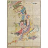
England & Wales. Walker (J. & C.), A Geological Map of England & Wales and part of Scotland, showing
England & Wales. Walker (J. & C.), A Geological Map of England & Wales and part of Scotland, showing also the Inland Navigation by means of Rivers...
England, Wales & Ireland. Vrients (Jan Baptista), Angliae et Hiberniae Accurata Descriptio Veteribus
England, Wales & Ireland. Vrients (Jan Baptista), Angliae et Hiberniae Accurata Descriptio Veteribus et Recentioribus Nominibus Illustrata, publis...
*English Channel. Mount (William & Page Thomas), A New chart of the British Channel extending from
*English Channel. Mount (William & Page Thomas), A New chart of the British Channel extending from North Foreland to Scilly Isles &c. on the Engli...
Folding maps. A mixed collection of approximately fifty maps, mostly 19th and early 20th century,
Folding maps. A mixed collection of approximately fifty maps, mostly 19th and early 20th century, folding engraved and lithographed maps of North ...
![Germany. Braun (Georg & Hogenberg Franz), Ratisbona, [1596], engraved town plan with contemporary](https://portal-images.azureedge.net/auctions-2018/srdom10105/images/210a1ad1-e677-41e9-db3b-f1a56de635bb.jpg?w=155&h=155)
Germany. Braun (Georg & Hogenberg Franz), Ratisbona, [1596], engraved town plan with contemporary
Germany. Braun (Georg & Hogenberg Franz), Ratisbona, [1596], engraved town plan with contemporary hand colouring, engraved by J. Hoefnagel, some o...
Gloucester. Cadle (C. & J.), Cadle's Map of the City of Gloucester Corrected to its Extended
Gloucester. Cadle (C. & J.), Cadle's Map of the City of Gloucester Corrected to its Extended Boundary 1877, published C. & J. Cadle, Gloucester, l...
![Greece. Ortelius (Abraham), Thraciae vecteris typus, [1612], hand coloured engraved map, 360 x 480](https://portal-images.azureedge.net/auctions-2018/srdom10105/images/84ad05dd-1d4d-41af-bbb4-9e7faf26b630.jpg?w=155&h=155)
Greece. Ortelius (Abraham), Thraciae vecteris typus, [1612], hand coloured engraved map, 360 x 480
Greece. Ortelius (Abraham), Thraciae vecteris typus, [1612], hand coloured engraved map, 360 x 480 mm, Latin text on verso Marcel van den Broecke,...
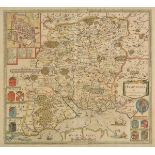
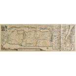
*Hampshire & Berkshire. Jansson (Jan), Hantoniae comitatus cum Bercheria, published Amsterdam, circa
*Hampshire & Berkshire. Jansson (Jan), Hantoniae comitatus cum Bercheria, published Amsterdam, circa 1648, engraved map with contemporary hand col...
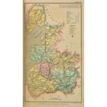
*Hampshire. Saxton (Christopher & Lea Philip), Hampshire by C. Saxton, Corected & many aditions by
*Hampshire. Saxton (Christopher & Lea Philip), Hampshire by C. Saxton, Corected & many aditions by P. Lea, circa 1695, engraved map with near cont...
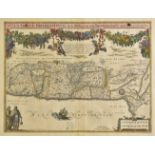
Hampshire. Speed (John), Hantshire described and devided, published J. Sudbury & George Humble,
Hampshire. Speed (John), Hantshire described and devided, published J. Sudbury & George Humble, circa 1627, hand coloured engraved map, inset town...
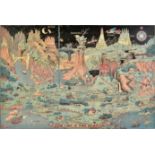
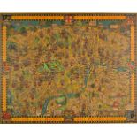
Hess (Jaro). The Land of Make Believe, published Michigan, 1930, colour printed allegorical map
Hess (Jaro). The Land of Make Believe, published Michigan, 1930, colour printed allegorical map showing an amalgamation of characters and scenes f...
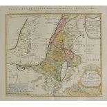
Holy Land. Homann (Johann Baptist, heirs of), Carte de la Terre Sainte divisee selon les d'ouze
Holy Land. Homann (Johann Baptist, heirs of), Carte de la Terre Sainte divisee selon les d'ouze Tribus d'Israel - Palestina in XII Tribus..., publ...
Holy Land. Calmet (Augustin), Carte de la Terre Promise, circa 1730, engraved map with outline
Holy Land. Calmet (Augustin), Carte de la Terre Promise, circa 1730, engraved map with outline colouring, a few marginal repaired closed tears, 32...
Holy Land. Tirinius (Jacobus), Chorographia terrae Sanctae in Angustiorem Formam redacta et ex
Holy Land. Tirinius (Jacobus), Chorographia terrae Sanctae in Angustiorem Formam redacta et ex variis auctoribus a multis erroribus expurgata, pub...
Holy Land. Jansson (Jan), Situs Terrae Promissionis. S. S. Bibliorum intelligentiam exacte aperiens per Chr. Adrichom, published Amsterdam, circa ...
Holy Land. Bonfrerius (Jacobus), Tabula Geographica Terrae Sanctae, Published F. Halma, Amsterdam, [1709], large hand coloured engraved map on two...
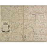
Ireland. Nevill (A. R., surveyor), To the Rte. Honble. and Honble. The Noblemen and Gentlemen of the
Ireland. Nevill (A. R., surveyor), To the Rte. Honble. and Honble. The Noblemen and Gentlemen of the County of Wicklow, This Map of said County, t...
Ireland. Ordnance Survey of Ireland, Map of Donegal, Barony Of Boylagh, published Dublin 1835 -
Ireland. Ordnance Survey of Ireland, Map of Donegal, Barony Of Boylagh, published Dublin 1835 - 36, twenty-one engraved maps with contemporary ou...
![Italy. Ortelius (Abraham), Larii Lacus vulgo comensis descriptio..., [on sheet with] Territorii](https://portal-images.azureedge.net/auctions-2018/srdom10105/images/79f42842-4666-4a1c-e499-2f06f33fa1f1.jpg?w=155&h=155)
Italy. Ortelius (Abraham), Larii Lacus vulgo comensis descriptio..., [on sheet with] Territorii
Italy. Ortelius (Abraham), Larii Lacus vulgo comensis descriptio..., [on sheet with] Territorii Romani Descrip [and] Fori Iulii vulgo Friuli typus...
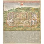
Jerusalem. Seutter (George Matthaus), Jerusalem cum suburbis prout tempore Christi floruit...,
Jerusalem. Seutter (George Matthaus), Jerusalem cum suburbis prout tempore Christi floruit..., published T. C. Lotter, Augsburg, circa 1740, engra...
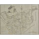
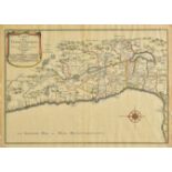
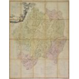
*Kent. Greenwood (C. & J.), Map of the County of Kent from an actual survey, 1829, engraved map with
*Kent. Greenwood (C. & J.), Map of the County of Kent from an actual survey, 1829, engraved map with contemporary hand colouring, engraved vignett...
London. Newton (William), London in the Olden Time, being a Topographical and Historical Memoir of
London. Newton (William), London in the Olden Time, being a Topographical and Historical Memoir of London, Westminster and Southwark, accompanying...
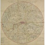
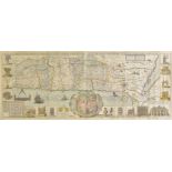
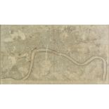
London. Faden (William), A Topographical Map of the Country Twenty Miles round London planned from a
London. Faden (William), A Topographical Map of the Country Twenty Miles round London planned from a scale of two miles to an inch, published Sept...
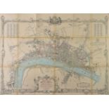
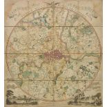
London. Cruchley ( George Frederick), Cruchley's Twelve miles round London, with additions to
London. Cruchley ( George Frederick), Cruchley's Twelve miles round London, with additions to 1833, engraved circular map, sectionalised and laid ...
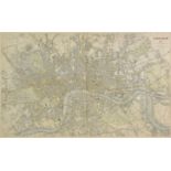
*London. Davies (Benjamin Rees), London..., Drawn and engraved from authentic documents & personal
*London. Davies (Benjamin Rees), London..., Drawn and engraved from authentic documents & personal observation..., published under the superintend...
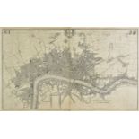
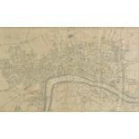
*London. Rocque (John), A plan of the cities of London and Westminster and Borough of Southwark,
*London. Rocque (John), A plan of the cities of London and Westminster and Borough of Southwark, with the Contiguous buildings..., published and s...
*London. London. Morden (Robert & Lea Philip), This Actuale Survey of London, Westminster, Southwark
*London. London. Morden (Robert & Lea Philip), This Actuale Survey of London, Westminster, Southwark is Humbly Dedicated to ye Ld. Major et Court ...
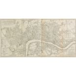
*London. Laurie (Robert & Whittle James), A New and Complete plan of London, Westminster & Borough
*London. Laurie (Robert & Whittle James), A New and Complete plan of London, Westminster & Borough of Southwark containing all the Improvements in...
*London. Anonymous. New and Accurate Plan of the Cities of London and Westminster and Borough of
*London. Anonymous. New and Accurate Plan of the Cities of London and Westminster and Borough of Southwark with the new Roads & New Buildings &c. ...
London. Fairburn (John), Fairburn's Map of the Country Twelve Miles round London, second edition
London. Fairburn (John), Fairburn's Map of the Country Twelve Miles round London, second edition with additions, published September 1st. 1800, en...
London. Gill (Macdonald), The Wonderground Map of London Town, published The Westminster Press,
London. Gill (Macdonald), The Wonderground Map of London Town, published The Westminster Press, circa 1928, colour photolithographic map, laid on ...
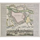
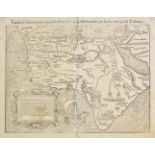
Maastricht. Seutter (George Matthaus), Plan du Project de Fortification sur la Ville de Maastrick et
Maastricht. Seutter (George Matthaus), Plan du Project de Fortification sur la Ville de Maastrick et sur la Fortification de Wyck fait par Albert ...